Photos • Location
| Kaali Landscape Conservation Area | |
|---|---|
 | |
| Location | Estonia |
| Coordinates | 58°22′10″N 22°40′10″E / 58.3694°N 22.6694°E |
| Area | 39 ha |
| Established | 1938 (2017) |
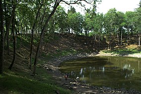
Kaali Landscape Conservation Area is a nature park situated in Saare County, Estonia. [1]
Its area is 39 ha. [2]
The protected area was designated in 1938 to protect Kaali crater and its surrounding areas. In 1959, the re-designation took place. In 2000, the borders were widened. [1]
- ^ a b "Kaali maastikukaitseala". keskkonnaportaal.ee. Retrieved 30 March 2021.
- ^ "Kaali Maastikukaitseala". Protected Planet. Retrieved 17 June 2021.
