Photos • Location

Boumerdès River

Zawiyet Sidi Boumerdassi
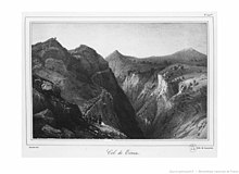
Expedition of the Col des Beni Aïcha (1837)

Mohamed Bouyahiaoui Hospital

Boumerdès District
دائرة بومرداس | |
|---|---|
 Map of Algeria highlighting Boumerdès Province | |
| Country | |
| Province | Boumerdès |
| District seat | Boumerdès |
| Population (1998) | |
| • Total | 60,652 |
| Time zone | UTC+01 ( CET) |
| Municipalities | 3 |
Boumerdès is a district in Boumerdès Province, Algeria. It was named after its capital, Boumerdès, which is also the capital of the province.
Municipalities
The district is further divided into 3 municipalities:
Neighbourhoods
The neighbourhoods of Boumerdès District are:


Villages
The villages of Boumerdès District are:
Geology
Several mountain peaks are found in this district:
- Ben Norah Mount (467 m)
- Bouarous Mount (444 m)
- Cap Blanc Mount (420 m)
Rivers

This district is crossed by several rivers:
- Meraldene River
- Beni Arab River
- Boumerdès River
- Corso River
- El Karma River
- Sidi Ali River
- Tatarig River
Religion

History
French conquest

Algerian Revolution
Salafist terrorism
- 2005 Tidjelabine bombing (29 July 2005)
- 2006 Tidjelabine bombing (19 June 2006)
- 2010 Tidjelabine bombing (7 April 2010)
Health

Sport
| Club | Division | Level | Location |
|---|---|---|---|
| RC Boumerdes | Ligue de Football de la Wilaya | 3 | Boumerdès |
| WR Tidjelabine | Ligue de Football de la Wilaya | 3 | Tidjelabine |
| JS Boumerdes | Ligue de Football de la Wilaya | 3 | Boumerdès |
Notable people
- Cheikh Boumerdassi (1818-1874)
- Brahim Boushaki (1912-1997)
- Mohamed Boumerdassi (1936-2010)
- Ali Bouyahiaoui (1928-1956)
- Mohamed Bouyahiaoui (1932-1958)
- Adel Djerrar (1990-)
- Mohamed Flissi (1990-)
- Ali Laskri (1955-)
- Ahmed Mahsas (1923-2013)
References
Capital:
Boumerdès | ||
| Baghlia District | .svg) | |
| Bordj Menaïel District | ||
| Boudouaou District | ||
| Boumerdès District | ||
| Dellys District | ||
| Isser District | ||
| Khemis El Khechna District | ||
| Naciria District | ||
| Thénia District | ||
| A | |
|---|---|
| B | |
| C | |
| D | |
| E | |
| F | |
| G | |
| H | |
| L | |
| M | |
| O | |
| S | |
| T | |
| Z | |
36°46′00″N 3°28′38″E / 36.76667°N 3.47722°E
|
| This article about a location in Boumerdès Province is a stub. You can help Wikipedia by expanding it. |