Photos • Location
(Redirected from
Yamoussoukro Airport)
Yamoussoukro International Airport Aéroport international de Yamoussoukro | |||||||||||
|---|---|---|---|---|---|---|---|---|---|---|---|
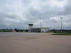
 Yamoussoukro Airport Terminal and Control Tower | |||||||||||
| Summary | |||||||||||
| Serves | Yamoussoukro | ||||||||||
| Location | Côte d'Ivoire | ||||||||||
| Elevation AMSL | 699 ft / 213 m | ||||||||||
| Runways | |||||||||||
| |||||||||||
Source: Google Maps
[1] | |||||||||||
Yamoussoukro International Airport ( French: Aéroport international de Yamoussoukro) is a regional airport serving Yamoussoukro in Côte d'Ivoire.
On November 6, 2004, Yamoussoukro Airport was attacked [2] by French infantry after military aircraft from the airport bombed a UN peacekeeper base as well as rebel targets, 9 French peacekeepers and one U.S. civilian were killed. Two Ivory Coast Sukhoi Su-25 aircraft and several Mil Mi-24 helicopters were destroyed, which was most of the country's air forces. Mobs and rebels tried to attack the French forces after the airport raid.
References
- ^ Google Maps - Yamoussoukro
- ^ "France attacks Ivorian airbase". 2004-11-06. Retrieved 2018-08-20.
6°54′11″N 5°21′56″W / 6.90317°N 5.36558°W