ကြိုဆိုပါတယ်။ / Welcome to the Myanmar Portal


Myanmar, officially the Republic of the Union of Myanmar and also known as Burma (the official name until 1989), is a country in Southeast Asia. It is the largest country by area in Mainland Southeast Asia and has a population of about 55 million. It is bordered by Bangladesh and India to its northwest, China to its northeast, Laos and Thailand to its east and southeast, and the Andaman Sea and the Bay of Bengal to its south and southwest. The country's capital city is Naypyidaw, and its largest city is Yangon (formerly Rangoon).
Myanmar is a member of the East Asia Summit, Non-Aligned Movement, ASEAN, and BIMSTEC, but it is not a member of the Commonwealth of Nations despite once being part of the British Empire. Myanmar is a Dialogue Partner of the Shanghai Cooperation Organization. The country is very rich in natural resources, such as jade, gems, oil, natural gas, teak and other minerals, as well as also endowed with renewable energy, having the highest solar power potential compared to other countries of the Great Mekong Subregion. However, Myanmar has long suffered from instability, factional violence, corruption, poor infrastructure, as well as a long history of colonial exploitation with little regard to human development. In 2013, its GDP (nominal) stood at US$56.7 billion and its GDP ( PPP) at US$221.5 billion. The income gap in Myanmar is among the widest in the world, as a large proportion of the economy is controlled by cronies of the military junta. Myanmar is one of the least developed countries; as of 2020, according to the Human Development Index, it ranks 147 out of 189 countries in terms of human development, the lowest in Southeast Asia. Since 2021, more than 600,000 people were displaced across Myanmar due to the surge in violence post-coup, with more than 3 million people in dire need of humanitarian assistance. ( Full article...)
Selected articles -
-

Lesbian, gay, bisexual, and transgender (LGBT) people in Myanmar face severe challenges not experienced by non-LGBT residents. Same-sex sexual activity is illegal and section 377 of Myanmar's Penal Code 1861, enacted in 1886, subjects same-sex sexual acts (regardless of whether they were consensual or done in private) to a term of imprisonment of up to 20 years in prison. Heterosexual anal intercourse and oral sex are also illegal. Transgender people are subject to police harassment and sexual assault, and their gender identity is not recognised by the state. During the country's long military dictatorship under the authoritarian State Peace and Development Council between 1988 and 2011, it was difficult to obtain accurate information about the legal or social status of LGBT Burmese citizens. Following the 2011–2015 Myanmar political reforms, improvements in media and civil freedoms have allowed LGBT people to gain more visibility and support in the country. Despite the 2015 electoral victory of the National League for Democracy, which promised improved human rights and whose leader Aung San Suu Kyi had once called for the decriminalisation of homosexuality, there have been no changes to anti-LGBT laws. Nevertheless, LGBT activists have noted a growing climate of societal acceptance and tolerance toward LGBT people, in line with worldwide trends. ( Full article...) -

Portrait of the Thirty Comrades
The Thirty Comrades ( Burmese: ရဲဘော်သုံးကျိပ်) constituted the embryo of the modern Burmese army called the Burma Independence Army (BIA) which was formed to fight for independence from Britain. This was accomplished just before the majority of the Thirty Comrades returned with the invading Japanese Army initially through Southern Burma in December 1941.
In April 1941, small groups of Burmese youth left Burma secretly to obtain military training to fight the British colonists in the struggle for independence. Their leader was Thakin Aung San and they were sent by the Dobama Asiayone ("We Burmans Association") with the intention to get assistance from Guangzhou. By a quirk of fate, however, they ran into the Japanese instead in Amoy and arrived in Japan later to be flown to occupied parts of Sanya, in order to receive military training from the Japanese Army. They were later moved to Formosa for security reasons and subsequently returned to Burma via Vietnam and
Thailand with the Japanese. On 26 December 1941, in a house (owned by a Burmese doctor) in Bangkok, about 25 of the Thirty Comrades had their blood drawn from their arms in syringes, then poured into a silver bowl from which each of them drank – thway thauk in time-honoured Burmese military tradition – pledging "eternal loyalty" among themselves and to the cause of Burmese independence. Their average age was just 24 years. A Japanese officer called Suzuki Keiji, better known among the Burmese by his nom de guerre Bo Mogyo (Commander Thunderbolt) and head of a special intelligence unit called Minami Kikan (南機関) formed in order to support a national uprising in Burma, was the mentor and principal trainer of the Thirty Comrades. The British were driven out of Burma to India during World War II. ( Full article...) -

Burmese nat statues in the shrine
The nats (နတ်; MLCTS: nat; IPA: [naʔ]) are god-like spirits venerated in Myanmar and neighbouring countries in conjunction with Buddhism. They are divided between the 37 Great Nats who were designated that status by King Anawrahta when he formalized the official list of nats. Most of the 37 Great Nats were human beings who met violent deaths.
There are two types of nats in Burmese Belief: nat sein (နတ်စိမ်း) which are humans that were deified after their deaths and all the other nats which are spirits of nature (spirits of water, trees etc.). ( Full article...) -
The print, broadcast and online mass media in Burma (also known as Myanmar) has undergone strict censorship and regulation since the 1962 Burmese coup d'état. The constitution provides for freedom of speech and the press; however, the government prohibits the exercise of these rights in practice. Reporters Without Borders ranked Burma 174th out of 178 in its 2010 Press Freedom Index, ahead of just Iran, Turkmenistan, North Korea, and Eritrea. In 2015, Burma moved up to 144th place, ahead of many of its ASEAN neighbours such as Singapore, as a result of political changes in the country.
There have been moves to lift censorship in the country. Tint Swe, head of the country's censorship body, the Press Scrutiny and Registration Division (PSRB), told Radio Free Asia that censorship "should be abolished in the near future" as it is "non-existent in most other countries" and "not in harmony with democratic practices." Burma announced on 20 August 2012, that it will stop censoring media before publication. Newspapers and other outlets would no longer have to be approved by state censors, but journalists in the country could still face consequences for what they write and say. ( Full article...) -
The 969 Movement ( Burmese: ၉၆၉ လှုပ်ရှားမှု) is a Buddhist nationalist movement opposed to what they see as Islam's expansion in predominantly Buddhist Myanmar ( Burma). The three digits of 969 "symbolize the virtues of the Buddha, Buddhist practices and the Buddhist community". The first 9 stands for the nine special attributes of the Buddha and the 6 for the six special attributes of his Dharma, or Buddhist Teachings, and the last 9 represents the nine special attributes of Buddhist Sangha (monastic community). Those special attributes are the Three Jewels of the Buddha. In the past, the Buddha, Sangha, Dhamma, the wheel of Dhamma, and "969" were Buddhist signs.
The movement has had strong reactions within and beyond Myanmar. In the international media it has received criticism. The Straits Times reported that Ashin Wirathu, the movement's leader, responded to recent anti-Muslim violence with pledges to work for peace, but critics remain sceptical. ( Full article...) -

Thura Ma Chit Po ( Burmese: သူရ မချစ်ပို; February 1908 – 8 April 1949) was a Burmese woman who was the one and only civilian woman to have received the Thura medal for bravery. She gathered intelligence on the Karen National Defence Organisation (KNDO) on behalf of the Myanmar Military before she was caught and executed by the KNDO insurgents. ( Full article...) -
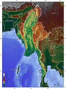
Myanmar (also known as Burma) is the northwesternmost country of mainland Southeast Asia located on the Indochinese peninsula. With an area of 261,228 sq mi (676,578 km2), it is the second largest country in Southeast Asia and the largest on mainland Southeast Asia. The kite-shaped country stretches from 10'N to 20'N for 1,275 miles (2,050 km) with a long tail running along the western coast of the Malay Peninsula.
Myanmar lies along the Indian and Eurasian Plates, to the southeast of the Tibetan Plateau. To its west is the Bay of Bengal and to its south is the Andaman Sea. The country is nestled between several mountain ranges with the Arakan Mountains on the west and the Shan Plateau dominating the east. The central valley follows the Irrawaddy River, the most economically important river to the country with 39.5 million people, including the largest city Yangon, living within its basin. The country is home to many diverse ethnic groups, with 135 officially recognized groups. It is strategically located near major Indian Ocean shipping lanes and was historically home to overland trade routes into China from the Bay of Bengal. The neighboring countries are China, India, Bangladesh, Thailand and Laos. ( Full article...) -
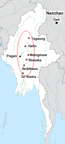
The Early Pagan Kingdom ( Burmese: ခေတ်ဦး ပုဂံ ပြည်) was a city-state that existed in the first millennium CE before the emergence of the Pagan Empire in the mid 11th century. The Burmese chronicles state that the "kingdom" was founded in the second century CE. The seat of power of the small kingdom was first located at Arimaddana, Thiri Pyissaya, and Tampawaddy until 849 CE when it was moved to Pagan (Bagan).
Radiocarbon dating shows the earliest human settlement in the Pagan region dates only from the mid-7th century CE. It existed alongside Pyu city-states that dominated Upper Burma. The city-state of Pagan, according to mainstream scholarship, was founded in the mid 9th century by the Mranma of Nanzhao Kingdom. Burmans at Pagan expanded irrigation-based cultivation while borrowing extensively from the Pyus' predominantly Buddhist culture. It was one of many competing city-states in the Pyu realm until the late 10th century when the principality began absorbing its surrounding states. The expansion accelerated in the 1050s and 1060s when King Anawrahta founded the Pagan Empire, the first ever unification of the Irrawaddy valley and its periphery. ( Full article...) -

Magway Region ( Burmese: မကွေးတိုင်းဒေသကြီး, pronounced [məɡwé táiɰ̃ dèθa̰ dʑí]; formerly Magway Division) is an administrative division in central Myanmar. It is the second largest of Myanmar's seven divisions, with an area of 44,820 km2 (17,306 square miles). Pa Del Dam (ပဒဲဆည်) is one of the dams in Aunglan Township, Magway Division. The capital and second largest city of the Magway Division is Magway. The largest city is Pakokku. The major cities of Magway Division are Magway, Pakokku, Aunglan, Yenangyaung, Taungdwingyi, Chauk, Minbu, Thayet and Gangaw. ( Full article...) -
The First Anglo-Burmese War ( Burmese: ပထမ အင်္ဂလိပ်-မြန်မာ စစ်; [pətʰəma̰ ɪ́ɰ̃ɡəleiʔ-mjəmà sɪʔ]; 5 March 1824 – 24 February 1826), also known as the First Burma War in English language accounts and First English Invasion War ( Burmese: ပထမ အင်္ဂလိပ် ကျူးကျော် စစ်) in Burmese language accounts, was the first of three wars fought between the British and Burmese empires in the 19th century. The war, which began primarily over the control of what is now Northeastern India, ended in a decisive British victory, giving the British total control of Assam, Manipur, Cachar and Jaintia as well as Arakan Province and Tenasserim. The Burmese submitted to a British demand to pay an indemnity of one million pounds sterling, and signed a commercial treaty.
The war was one of the most expensive in British Indian history. Fifteen thousand European and Indian soldiers died, together with an unknown number of Burmese military and civilian casualties. The high cost of the campaign to the British, 5–13 million pounds sterling (£500 million – £1.38 billion as of 2023) contributed to a severe economic crisis in British India which cost the East India Company its remaining privileges. ( Full article...)


Did you know (auto-generated) -

- ... that Molly Burman resumed releasing music three years later after finding that "Happy Things" had accrued a million streams on Spotify?
- ... that Aung Myo Min, Union Minister of Human Rights for the National Unity Government of Myanmar, is the country's first openly LGBT minister?
- ... that Rangoon kept its own time for more than two decades after Burma Standard Time first came into effect?
- ... that Maung O, Prince of Salin, and his sister Nanmadaw Me Nu became de facto rulers of Burma when King Bagyidaw was suffering from depression?
- ... that the Burmese Buddhist monk Sagyo Thu-Myat successfully lobbied for the recalibration of the Burmese calendar?
- ... that Thinzar Shunlei Yi hid in the Burmese jungle for a month and joined a rebel militia following the 2021 Myanmar coup d'état?
- ... that squatters in Myanmar were punished for protesting against the 2021 coup d'état by being evicted?
- ... that one academic described the introduction of femboys to Myanmar as a tactic to achieve an "ideological revolution"?
Related portals and projects
General images -
-

-
 British soldiers dismantling cannons belonging to King Thibaw's forces, Third Anglo-Burmese War, Ava, 27 November 1885. Photographer: Hooper, Willoughby Wallace (1837–1912). (from History of Myanmar)
 -
 Temples at Mrauk U, was the capital of the Mrauk U Kingdom, which ruled over what is now Rakhine State. (from History of Myanmar)
 -
 Myinhkin thabin - equestrian sport (from Culture of Myanmar)
 -
 A large fracture on the Mingun Pahtodawgyi caused by the 1839 Ava earthquake. (from Geography of Myanmar)
 -
 Saint Mary's Cathedral in Downtown Yangon is the largest Roman Catholic cathedral in Burma. (from Culture of Myanmar)
 -
 Aerial view of a burned Rohingya village in Rakhine state, Myanmar, September 2017 (from History of Myanmar)
 -
 19th-century funeral cart and spire, which would form part of the procession from the home to the place of cremation (from Culture of Myanmar)
 -
 A theatrical performance of the Mon dance (from Culture of Myanmar)
 -
 Mountains near Pindaya on the Shan Plateau (from Geography of Myanmar)
 -
 British soldiers on patrol in the ruins of the Burmese town of Bahe during the advance on Mandalay, January 1945. (from History of Myanmar)
 -
 A bull fight, 19th-century watercolour (from Culture of Myanmar)
 -
 The restored Taungoo or Nyaungyan dynasty c. 1650 CE. (from History of Myanmar)
 -

-
 Mount Popa, a dormant volcano in the Central Lowlands (from Geography of Myanmar)
 -
 Salween river at Mae Sam Laep on the Thai-Myanmar border (from Geography of Myanmar)
 -

-
 Former US President Barack Obama poses barefoot on the grounds of Shwedagon Pagoda, one of Myanmar's major Buddhist pilgrimage sites. (from Culture of Myanmar)
 -
 The shores of Irrawaddy River at Nyaung-U, Bagan (from Geography of Myanmar)
 -
 Protesters in Yangon with a banner that reads non-violence: national movement in Burmese, in the background is Shwedagon Pagoda. (from History of Myanmar)
 -

-
 Jade Mine in Hpakant (from Geography of Myanmar)
 -
 Aung San Suu Kyi addresses crowds at the NLD headquarters shortly after her release. (from History of Myanmar)
 -
 Sculpture of Myanmar mythical lion (from Culture of Myanmar)
 -
 Protesters in Yangon carrying signs reading "Free Daw Aung San Suu Kyi" on 8 February 2021. (from History of Myanmar)
 -
 A wedding procession, with the groom and bride dressed in traditional Burmese wedding clothes, reminiscent of royal attire (from Culture of Myanmar)
 -
 Myanmar (Burma) map of Köppen climate classification (from Geography of Myanmar)
 -
 Vegetable stall on the roadside at the Madras Lancer Lines, Mandalay, January 1886. Photographer: Hooper, Willoughby Wallace (1837–1912). (from History of Myanmar)
 -
 British soldiers remove their shoes at the entrance of Shwedagon Pagoda. To the left, a sign reads "Foot wearing is strictly prohibited" in Burmese, English, Tamil, and Urdu. (from Culture of Myanmar)
 -
 Recorder's Court on Sule Pagoda Road, with the Sule Pagoda at the far end, Rangoon, 1868. Photographer: J. Jackson. (from History of Myanmar)
 -
 Two female musicians play the saung at a performance in Mandalay. (from Culture of Myanmar)
 -
 The paddle steamer Ramapoora (right) of the British India Steam Navigation Company on the Rangoon river having just arrived from Moulmein. 1895. Photographers: Watts and Skeen (from History of Myanmar)
 -
 A wide range of Burmese lacquerware from Bagan (from Culture of Myanmar)
 -
 Political Map of Burma (Myanmar) c. 1450 CE. (from History of Myanmar)
 -
 Portuguese ruler and soldiers mounting an Elephant. Philips, Jan Caspar (draughtsman and engraver) (from History of Myanmar)
 -
 Pagan Kingdom during Narapatisithu's reign. Burmese chronicles also claim Kengtung and Chiang Mai. Core areas shown in darker yellow. Peripheral areas in light yellow. Pagan incorporated key ports of Lower Burma into its core administration by the 13th century. (from History of Myanmar)
 -
 Hlei pyaingbwè - a Burmese regatta (from Culture of Myanmar)
 -
 Boxing match, 19th-century watercolour (from Culture of Myanmar)
 -
 Grandfather Island, Dawei (from Geography of Myanmar)
 -
 A group of Buddhist worshipers at Shwedagon Pagoda, an important religious site for Burmese Buddhists (from Culture of Myanmar)


_headquarter.jpg)


Major topics
Categories

More topics

Associated Wikimedia
The following Wikimedia Foundation sister projects provide more on this subject:
-
 Commons
Free media repository -
 Wikibooks
Free textbooks and manuals -
 Wikidata
Free knowledge base -
 Wikinews
Free-content news -
 Wikiquote
Collection of quotations -
 Wikisource
Free-content library -
 Wikiversity
Free learning tools -
 Wikivoyage
Free travel guide -
 Wiktionary
Dictionary and thesaurus


