-
 The Rhesus Macaque (Macaca mulatta) is one of the best-known species of Old World monkeys native in Bangladesh. The pictured macaque is seen eating from a jackfruit at Lawachara National Park, Moulvibazar.
Photo Credit: Syedabbas321
-
 The Indian pitta (Pitta brachyura) is a passerine bird native to the Indian subcontinent. It inhabits scrub jungle, deciduous and dense evergreen forest. The pictured specimen was photographed at Bhawal National Park.
Photo Credit: Md shahanshah bappy
-
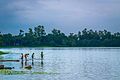 Ramsagar National Park is a national park in Bangladesh located at Tejpur, near Dinajpur District in the northwest of the country. The Park is 27.76 hectare, in size, and is built around a large water reservoir known as "Ramsagar reservoir" built in the 18th century by Raja Ram Nath. The photograph shows young children from the locality fishin in the reservoir.
Photo Credit: Jubair1985
-
 Somapura Mahavihara in Paharpur, Badalgachhi Upazila, Naogaon District, Bangladesh is among the best known Buddhist viharas in the Indian subcontinent and is one of the most important archeological sites in the country. It was designated as a UNESCO World Heritage Site in 1985.
Photo Credit: Kazi Rashed Abdallah
-
 Jatiyo Sangsad Bhaban is the National Assembly Building of Bangladesh, located in the capital Dhaka. It was created by architect Louis I. Kahn and is one of the largest legislative complexes in the world. It houses all parliamentary activities of Bangladesh. This photo offers a close view of a section of the parliament building.
Photo Credit: Nahid Sultan & Saiful Aopu
-
 In Bangladesh there are many tribal people live in Sylhet, Dinajpur, Cox's Bazar, Mymensingh, Rajshahi etc. But majority of tribal people live in the Chittagong Hill Tracts. This picture features a tribal kid with her little sister tied in her back at Farukpara, Bandarban, Bangladesh.
Photo Credit: Mohammad Rakibul Hasan
-
 Baitul Mukarram is the National Mosque of Bangladesh. Located at the center of Dhaka, capital of Bangladesh, the mosque was completed in 1968.
Photo Credit: Jubair1985
-
 Dhakeshwari Temple is a famous state-owned Hindu temple in Dhaka, Bangladesh built in the 12th century. The temple is located southwest of the Salimullah Hall of Dhaka University. This image shows Shiva temple structures inside the Dhakeshwari Temple complex.
Photo Credit: Ragib Hasan
-
 Jatiyo Sangsad Bhaban is the National Assembly Building of Bangladesh, located in the capital Dhaka. It was created by architect Louis I. Kahn and is one of the largest legislative complexes in the world. It houses all parliamentary activities of Bangladesh. This photo offers a close view of a section of the parliament building.
Photo Credit: justinstravels
-
 The Padma Multipurpose Bridge is a multipurpose road-rail bridge across the Padma River, the main distributary of Ganges, under construction in Bangladesh. The image features a beautiful morning view of Padma Bridge under construction (November 2021).
Photo Credit: Nahian Bin Shafiq
-
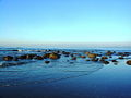 St. Martin's Island is a small island in the northeast part of the Bay of Bengal, about 9 km south of the tip of the Cox's Bazar- Teknaf peninsula, and forming the southernmost part of Bangladesh. It is the only coral island in Bangladesh. This picture features the dead corals of The Saint Martin's Island.
Photo Credit: Mirza Salman Hossain Beg
-
 Bandarban, one of the remotest districts of Bangladesh, is famous for the beauty of its hilly terrain. The numerous Buddhist temples and bihars in the town, Prantik Lake, Jibannagar and Kyachlong Lake are some more places of interest. This image shows the skyline of the district from the pouplar Nilachol resort managed by Bangladesh Parjatan Corporation.
Photo Credit: Fahad Faisal
-
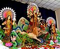 Durga Puja is the biggest festival of Hindus in Assam, Bihar, West Bengal, Jharkhand, and Bangladesh, and of Bengali Hindus all over the world. It is also called Akalbodhan, Vijaya Dashami, Dashain, and Dussehra. The image shows celebration of the festival at Dhakeshwari Temple, the national temple of Bangladesh.
Photo Credit: Rajiv Ashrafi
-
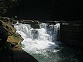
 Madhabkunda waterfall is one of the highest waterfalls in Bangladesh. It is situated in Barlekha Upazila in Moulvibazar District, Sylhet Division. The waterfall is a popular tourist spot in Bangladesh. Big boulders, surrounding forest, and the adjoining streams attracts many tourists for picnic parties and day trips.
Photo Credit: Jubair1985
-
 The chestnut-capped babbler (Timalia pileata) is a passerine bird of the Timaliidae. It is monotypic within the genus Timalia. The pictured specimen of this native bird of Bangladesh was photographed at Himchari National Garden, Cox's Bazar.
Photo Credit: Syedabbas321
-
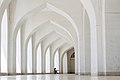
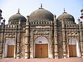 The Khan Mohammad Mridha Mosque on Lalbagh road is situated less than half a kilometre west of the Lalbagh Fort, in an area called Atish Khana in old Dhaka. Two Persian inscriptions, one over the central archway and the other over the central Mihrab, speak of its construction during 1704–05 AD.
Photo Credit: Ragib Hasan
-
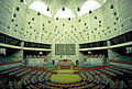 Jatiyo Sangsad Bhaban is the National Assembly Building of Bangladesh, located in the capital Dhaka. It was created by architect Louis I. Kahn and is one of the largest legislative complexes in the world. It houses all parliamentary activities of Bangladesh. This photo offers a view of the assembly hall inside the parliament building
Photo Credit: Rossi101
-
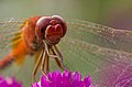 Numerous species of Dragonflies are native in Bangladesh. The pictured specimen was photographed at Baldha Garden, Dhaka.
Photo Credit: Azim Khan Ronnie
-
 Shuvolong is a place in Barkol sub district, located about 25 kilometres (11 kilometres as the crow flies) away from Rangamati town. There are a few waterfalls in Shuvolong area with the largest one falling from as high as 300 feet. Shuvolong is accessible by speed boat or motor boats from Rangamati. The photo features Shovolong water falls in October (before winter).
Photo Credit: Mirza Salman Hossain Beg, Bangladesh
-
 Ratargul Swamp Forest is a freshwater swamp forest located in Gowain River, Fatehpur Union, Gowainghat, Sylhet, Bangladesh. It is the only swamp forest located in Bangladesh and one of the few freshwater swamp forest in the world. The forest is naturally conserved under the Department of Forestry, Govt. of Bangladesh.
Photo Credit: Sumon Mallick
-
 Sripur is a tourist spot in Bangladesh's Sylhet district. It is well known for its waterfalls, which span across the Bangladesh- India border. This picture features a tea garden in Sripur, Sylhet, Bangladesh
Photo Credit: Moheen Reeyad
-
 Egrets are herons which have white or buff plumage, and develop fine plumes (usually milky white) during the breeding season.. The pictured specimens were photographed at Sundarbans East Wildlife Sanctuary, Bagerhat.
Photo Credit: Md shahanshah bappy
-
 Pond herons are herons, typically 40–50 cm (16–20 in) long with an 80–100 cm (31–39 in) wingspan, which mostly breed in the tropical Old World. The photo shows a heron at Bangabandhu Sheikh Mujib Safari Park.
Photo Credit: Abdul Momin
-
 Bengal Tiger, the national animal of Bangladesh, is a subspecies of tiger primarily found in Indian subcontinent. In the Sunderbans, a 2004 census found the presence of about 280 Tigers on the India side & 500 tigers on the Bangladesh side.
Photo Credit: Hollingsworth, John and Karen, retouched by Zwoenitzer
-
 The oriental garden lizard, eastern garden lizard or changeable lizard (Calotes versicolor) is an agamid lizard found widely distributed in Asia. The pictured specimen was photographed at National Botanical Gardens, Dhaka.
Photo Credit: Azim Khan Ronnie
-
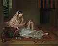 Muslin is a cotton fabric of plain weave made in a wide range of weights from delicate sheers to coarse sheeting. Early muslin was hand woven of uncommonly delicate handspun yarn, especially in the region around Dhaka, Bengal (now Bangladesh). The picture depicts an 18th-century woman in Dhaka clad in fine Bengali muslin.
Photo Credit: Francesco Renaldi
-
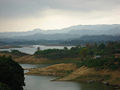
 Kaptai Lake is the largest man made lake in Bangladesh. It is located in the Kaptai Upazila under Rangamati District of Chittagong Division. The lake was created as a result of building the Kaptai Dam on the Karnaphuli River, as part of the Karnaphuli Hydro-electric project. The Kaptai Lake's average depth is 100 feet (30 m) and maximum depth is 490 feet (150 m).
Photo Credit: Fahad Faisal
-
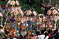 Pohela Baishakh, is the first day of the Bengali calendar, celebrated in both Bangladesh and Bengali communities across India. The most colourful New Year's Day festival takes place in Dhaka, as the students and teachers of Institute of Fine Arts, University of Dhaka take out a colourful procession and parade round the campus. This image shows a glimpse of the parade.
Photo Credit: Niloy
-
 Chandanpura Nachghar is an ancient building located adjacent to Chandanpura Fire Service Station, along Nawab Siraj-ud-Daulah road in Chittagong, Bangladesh. It is known as the dance hall of the Zamindar house of Sajjalela. The building, once used as the Chittagong Divisional Fire Service Office, is currently preserved as the proposed Fire Service and Civil Defense Museum.
Photo Credit: Intakhab
-
 Shaheed Minar, or the Martyr's monument, located near Dhaka Medical College was established to pay the tribute to the martyrs of the Bengali language movement of 1952 and as such has become the center of commemoration of Language Movement Day, in Bangladesh on February 21 every year.
Photo Credit: Karl Ernst Roehl
-
 Although rice is the staple food of Bangladesh, wheat holds an important position is a summplementary staple corp. The image was captured in a wheat field in the Natore District.
Photo Credit: Jubair1985
-
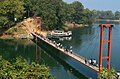 The District of Rangamati is a part of the Chittagong Hill Tracts and is one of the most beautiful districts of the country. Its beauty lies in the people, culture, landscape and lifestyle. The Hanging Bridge at Rangamti district, pictured here, is a famous landmark and tourist attraction of the district.
Photo Credit: Shakhawat Hossen Shafat
-
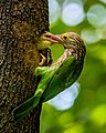 The lineated barbet (Psilopogon lineatus) is an Asian barbet native to the Terai, the Brahmaputra basin to Southeast Asia. It is a frugivore and nests in holes of tree trunks. The pictured specimen was photographed at National Botanical Gardens, Dhaka.
Photo Credit: Nafis Ameen
-
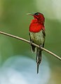 The crimson sunbird (Aethopyga siparaja) is a species of bird native in Bangladesh. The pictured specimen was photographed at Modhutila Eco-Park in Sherpur District.
Photo Credit: Masud Rana
-
 This is a photographic reproduction of an original two-dimensional work of art by Francis Hayman (1708–1776) created in 1762. The artwork is showing Lord Clive meeting with Mir Jafar after the Battle of Plassey (1757). The painting was displayed in Vauxhall soon after completion.
Photo Credit: www.sterlingtimes.org
-
 NgafaKhong (native Marma term) or Nafa-khum waterfall is situated on the Remaikree River, a tributory of Sangu river. The wild hilly Remaikree river suddenly falls down here about 25–30 feet. The falls are located in a remote area two hours' walking distance from Remakree bazar, Thanchi Upazila, Bandarban District.
Photo Credit: Abu Md. Jakaria
-
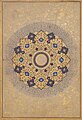 The image features a Rosette Bearing the Names and Titles of Shah Jahan; Folio from the Shah Jahan Album. It depicts a shamsa (literally, sun) traditionally opened imperial Mughal albums. Worked in bright colors and several tones of gold, the meticulously designed and painted arabesques are enriched by fantastic flowers, birds, and animals. The inscription in the center reads: "His Majesty Shihabuddin Muhammad Shahjahan, the King, Warrior of the Faith, may God perpetuate his kingdom and sovereignty.".
Photo Credit: Metropolitan Museum of Art
-
 Cox's Bazar in Bangladesh known for its wide sandy beach, is believed to be the world's longest (120 km) natural sandy sea beach. It is located 152 km south of Chittagong. The photo features a beach restaurant at Cox's Bazar.
Photo Credit: Xalan mustafa
-
 An old man carrying two baskets on a stick through a field of tea plants in Jaflong, Sylhet, Bangladesh, with misty hills in the background.
Photo Credit: Abdul Momin
-
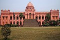
 The Uttara Ganabhaban (meaning Northern People's House) is an 18th-century (1734) royal palace also known as Dighapatia Rajbari as it was formerly the seat of the Dighapatia Raj, an aristocratic landed estate in the Bengal Presidency of the British Raj. It is located near Natore town and serves as the principal residence of the Bangladeshi Prime Minister in the northern part of the country.
Photo Credit: Rohan Uddin Fahad
-
 The Asian pied starling (Sturnus contra) is one of the 12 bird species of family Sturnidae resident in Bangladesh. Locally known as myna or shalik, these birds build their nests in holes or cavities in trees or buildings, or large globular structures of straw, twigs, etc. in trees.
Photo Credit: J.M.Garg
-
 Cox's Bazar in Bangladesh known for its wide sandy beach, is believed to be the world's longest (120 km) natural sandy sea beach. It is located 152 km south of Chittagong.
Photo Credit: ed g2s
-
 Magpie Robin, a very common bird in Bangladesh - locally known as Doyel or Doel ( Bengali: দোয়েল), is designated as the National Bird of the country.
Photo Credit: J.M.Garg
-
 Jamuna Multi-purpose Bridge, opened in June 1998 connects Bhuapur on the Jamuna River's east bank to Sirajganj on its west bank. The 5th longest bridge in South Asia established a strategic link between the eastern and western parts of Bangladesh.
Photo Credit: Arman Aziz
-
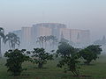 Jatiyo Sangsad Bhaban is the National Assembly Building of Bangladesh, located in the capital Dhaka. It was created by architect Louis I. Kahn and is one of the largest legislative complexes in the world. It houses all parliamentary activities of Bangladesh. This photo offers a view of the parliament building during sunrise.
Photo Credit: Lykantrop
-
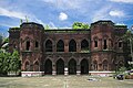
 Chittagong War Cemetery is a Commonwealth War Graves Commission cemetery located at Dampara 22 kilometers north of the airport and 8 kilometers from the port. The burial area is surrounded by a large plantation. A tarmac lane leads from the entrance gate to the burial area which is entered through a metal gate flanked by two small brick chapels.
Photo Credit: Hossain Toufique Iftekher
-
 Jatiyo Sangsad Bhaban is the National Assembly Building of Bangladesh, located in the capital Dhaka. It was created by architect Louis I. Kahn and is one of the largest legislative complexes in the world. It houses all parliamentary activities of Bangladesh.
Photo Credit: Karl Ernst Roehl
-
 The river Buriganga is economically very important to Dhaka. Even during the Mughal rules the banks of the Buriganga were already a prime location for trade. Today the river provides vital connectivity between the capital city and many districts. The photograph features a launch sailing from Sadarghat on the Buriganga during sunset.
Photo Credit: Jubair1985
-
 Fantails are small insectivorous birds of Australasia, Southeast Asia and the Indian subcontinent of the genus Rhipidura in the family Rhipiduridae. The pictured specimen was photographed at Bhawal National Park.
Photo Credit: Md shahanshah bappy
-
 Himchari National Park located just south of the Cox's Bazar town consists of lush tropical rain forest, grasslands and trees, and features a number of waterfalls, the biggest of which cascades down toward the sandy, sun-drenched beach. The National Park was established in 1980 as a conservation area for research, education and recreation.
Photo Credit: Shuvra Dutta
-
 Ahsan Manzil, the official residential palace and seat of the Dhaka Nawab Family, situated on the banks of the Buriganga River. The palace is now a museum.
Photo Credit: Mahbub Hossain Shaheed (mahosha)
-
 Dinajpur Railway Bridge on Punorvoba River is an important landmark facilitating rail connectivity between Dinajpur District and rest of the country.
Photo Credit: Jubair1985
-
 The blue peafowl (Pavo cristatus), a large and brightly coloured bird, is a species of peafowl native to the Indian subcontinent, but introduced in many other parts of the world. The photo shows a peacock displaying its train at Bangabandhu Sheikh Mujib Safari Park.
Photo Credit: Azim Khan Ronnie
-
 Patenga, a sea beach and popular tourist spot, is located 14 kilometres south of the port city of Chittagong, Bangladesh, near the mouth of the Karnaphuli River. The beach is very close to BNS Isha Khan Naval Base of Bangladesh Navy, and Shah Amanat International Airport.
Photo Credit: Ziaul Hoque
-
 Lawachara National Park is a major national park and nature reserve in Bangladesh. The park is located at Kamalganj Upazila, Maulvi Bazar District in the northeastern region of the country. The park covers approximately 1,250 ha (12.5 km2) of semi- evergreen forest Biome and mixed deciduous forest Biome.
Photo Credit: Pallabkabir
-
 The Brahminy kite (Haliastur indus) is a medium-sized bird of prey in the family Accipitridae found in the Indian subcontinent, Southeast Asia and Australia. They are found mainly on the coast and in inland wetlands, where they feed on dead fish and other prey. Adults have a reddish-brown body plumage contrasting with their white head and breast which make them easy to distinguish from other birds of prey. The pictured specimen was photographed at Kuakata Eco-Park.
Photo Credit: Md. Tareq Aziz Touhid
-
 St. Martin's Island is a small island in the northeastern part of the Bay of Bengal, about 9 km south of the tip of the Cox's Bazar- Teknaf peninsula, and forming the southernmost part of Bangladesh. There is a small adjoining island that is separated at high tide, called Chera Dwip. It is about 8 kilometres (5 miles) west of the northwest coast of Myanmar, at the mouth of the Naf River.
Photo Credit: Niaz morshed Shovon
-
 Pari Bibi's mazar at the Lalbagh Fort, the center of Mughal military power in Dhaka and an intrinsic part of the history of the city, founded by Muhammad Azam Shah in 1678.
Photo Credit: Md. Shahed Faisal
-
 The pictured Shiva Temple is situated in Puthia Bazar of Rajshahi District. It was built on a hing plinth on the southern bank of a large tank. The temple is a 19.81 meter square building and total height is 35.03 meter. It is a Pancha Ratna type building consists of a Garbhagriha and a surrounding verandah. Rani Bhubanmoye Debi built this temple in 1823 AD.
Photo Credit: Nasir Khan Saikat
-
 Hardinge Bridge is a steel railway bridge over the river Padma located at Paksey, Ishwardi, Pabna in western Bangladesh. It is named after Lord Hardinge, who was the Viceroy of India from 1910 to 1916. The bridge is 1.8 kilometres (1.1 mi) long.
Photo Credit: Azim Khan Ronnie
-
 The District of Rangamati is a part of the Chittagong Hill Tracts and is one of the most beautiful districts of the country. Its beauty lies in the people, culture, landscape and lifestyle. This picture featuring the skyline of Rangamati has been taken at Tabalchhori at BDR Rangamati.
Photo Credit: Sakib
-
 The Pancha Ratna Govinda Temple in is located at Puthia village in Rajshahi district in Bangladesh. The temple is a striking monument built in the 19th century. It has the architectural feature of five ratnas or spires. It is located within the inner precincts of the Puthia Rajbari or palace.
Photo Credit: RockyMasum
-
 Bagakain Lake, also called Boga Lake is located in Ruma Upazila in Bandarban. It is a natural sweet and deep water lake situated nearly 1,246 feet (380 m) above sea level. The irregularly shaped lake is bounded on three sides by mountain peaks covered with thick bamboo bushes.
Photo Credit: Masum Ibn Musa
-
 Chomchom is a traditional Bengali sweet originated from Porabari, Tangail, Bangladesh. It is a very popular dessert in Bangladesh and India. The cuisine comes in a variety of colors, mainly light pink, light yellow, and white. It is coated with coconut or mawa flakes as a garnish. The sweet is oval and brownish.
Photo Credit: P.K.Niyogi
-
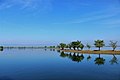 Tanguar haor, located in Sunamganj District, is a unique wetland ecosystem of national importance and has come into international focus. In 2000, the hoar basin was declared a Ramsar site - wetland of international importance.
Photo Credit: Sabirul Islam Biplob
-
 Numerous species of Calliphoridae or blow fly commonly known as Green bottle fly are found in Bangladesh. The pictured specimen was photographed at Baldha Garden, Dhaka.
Photo Credit: Azim Khan Ronnie
-
 Natore Rajbari (also known as Pagla Raja's Palace, Natore Palace) was a prominent royal palace in Natore, Bangladesh. It was the residence and seat of the Rajshahi Raj family of zamindars. The famous queen Rani Bhabani lived here and after the death of her husband, expanded both the estate and the palace.
Photo Credit: Nur-E-Saud


.jpg)
.jpg)


.jpg)


.jpg)


_2.jpg)


_on_Kapok_(Ceiba_pentandra)_in_Kolkata_W_IMG_4513.jpg)

-_Male_at_Kolkata_I_IMG_3003.jpg)


.jpg)


.jpg)


.jpg)


