Mahaboboka | |
|---|---|
 Mahaboboka | |
 Mahaboboka Location in Madagascar | |
| Coordinates: 22°54′S 44°20′E / 22.900°S 44.333°E | |
| Country | |
| Region | Atsimo-Andrefana |
| District | Sakaraha |
| Elevation | 313 m (1,027 ft) |
| Population (2018) | |
| • Total | 13,115 |
| Time zone | UTC3 ( EAT) |
Mahaboboka is a town and commune ( Malagasy: kaominina) in Madagascar. It belongs to the district of Sakaraha, which is a part of Atsimo-Andrefana Region. The population of the commune was estimated to be approximately 13,115 in 2018.
Primary and junior level secondary education are available in town. Mahaboboka has a police station, an Orthodox Church and a mosque. Traditional graves can be seen close to the road around Mahaboboka. The majority 80% of the population of the commune are farmers, while an additional 10% receives their livelihood from raising livestock. The most important crop is rice, while other important products are cassava and sweet potatoes. Services provide employment for 8% of the population. Additionally fishing employs 2% of the population. [2]
Geology
West of the Ilova fault, the Sakaraha–Toliara road crosses upper Jurassic marls and limestones. [3] To the north, they have yielded ammonites, [4] and to the north-west, they are succeeded by Cretaceous sedimentary rocks and basalts.
Economy
Natural gas has been discovered in Mahaboboka in 2016. [5]
Also minerals, as sapphires are found at Mahaboboka.
Rivers
Mahaboboka lies at the Fiherenana River.
-
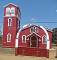 Orthodox church in Mahaboboka
 -
 Traditional graves near Mahaboboka
 -
 Typical landscape near Mahaboboka
 -
 Typical vegetation near Mahaboboka


References and notes
- ^ Estimated based on DEM data from Shuttle Radar Topography Mission
- ^ "ILO census data". Cornell University. 2002. Retrieved 2008-03-25.
- ^ Besairie & Collignon (1972). "Géologie de Madagascar. 1. Les Terrains sédimentaires".
- ^ GondwanaFossils. "Where in Madagascar do large Jurassic ammonites come from ?".
- ^ (in French) www.midi-madagasikara.mg
Capital:
Toliara | ||
| Ampanihy Ouest (19) - 605 |  | |
| Ankazoabo - 606 - (10) | ||
| Benenitra - 610 - (6) | ||
| Beroroha - 611 - (9) | ||
| Betioky-Atsimo -612 - (31) |
| |
| Morombe (9) - 618 | ||
| Sakaraha (12) - 620 | ||
| Toliara I (1) | ||
| Toliara II (22) (602) | ||
9 districts; 119 communes | ||
22°54′S 44°20′E / 22.900°S 44.333°E
|
| This Atsimo-Andrefana location article is a stub. You can help Wikipedia by expanding it. |