Photos • Location
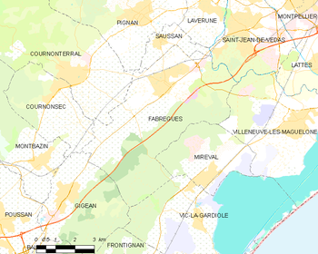
Map


Fabrègues | |
|---|---|
 A general view of Fabrègues | |
.svg) Coat of arms | |
 Fabrègues  Fabrègues | |
| Coordinates: 43°33′05″N 3°46′37″E / 43.5514°N 3.7769°E | |
| Country | France |
| Region | Occitania |
| Department | Hérault |
| Arrondissement | Montpellier |
| Canton | Pignan |
| Intercommunality | Montpellier Méditerranée Métropole |
| Government | |
| • Mayor (2020–2026) | Jacques Martinier [1] |
| Area 1 | 31.46 km2 (12.15 sq mi) |
| Population (2021)
[2] | 7,197 |
| • Density | 230/km2 (590/sq mi) |
| Time zone | UTC+01:00 ( CET) |
| • Summer ( DST) | UTC+02:00 ( CEST) |
| INSEE/Postal code |
34095 /34690 |
| Elevation | 10–224 m (33–735 ft) |
| 1 French Land Register data, which excludes lakes, ponds, glaciers > 1 km2 (0.386 sq mi or 247 acres) and river estuaries. | |
Fabrègues (French pronunciation: [fabʁɛɡ]; Occitan: Fabregas) is a commune in the Hérault department in southern France.

Population
| Year | Pop. | ±% p.a. |
|---|---|---|
| 1968 | 1,771 | — |
| 1975 | 2,522 | +5.18% |
| 1982 | 2,915 | +2.09% |
| 1990 | 4,089 | +4.32% |
| 1999 | 5,901 | +4.16% |
| 2007 | 6,180 | +0.58% |
| 2012 | 6,290 | +0.35% |
| 2017 | 7,035 | +2.26% |
| Source: INSEE [3] | ||
See also
References
- ^ "Répertoire national des élus: les maires". data.gouv.fr, Plateforme ouverte des données publiques françaises (in French). 2 December 2020.
- ^ "Populations légales 2021". The National Institute of Statistics and Economic Studies. 28 December 2023.
- ^ Population en historique depuis 1968, INSEE
External links
Wikimedia Commons has media related to
Fabrègues.
| International | |
|---|---|
| National | |
|
| This Hérault geographical article is a stub. You can help Wikipedia by expanding it. |