Photos • Location

| Site of Special Scientific Interest | |
 The
River Bourne | |
| Location | Kent |
|---|---|
| Grid reference | TQ 606 549 [1] |
| Interest | Biological |
| Area | 13.4 hectares (33 acres) [1] |
| Notification | 1987 [1] |
| Location map | Magic Map |
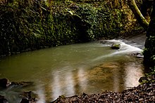
Bourne Alder Carr is a 13.4-hectare (33-acre) biological Site of Special Scientific Interest east of Sevenoaks in Kent. [1] [2]
The River Bourne runs through a shallow valley, and frequent flushing of the woodland on the banks with water rich in nutrients creates a rich ground flora. There is also an area of swamp around a fish pond. [3]
Roads and footpaths go through this site.
References
- ^ a b c d "Designated Sites View: Bourne Alder Carr". Sites of Special Scientific Interest. Natural England. Retrieved 30 January 2018.
- ^ "Map of Bourne Alder Carr". Sites of Special Scientific Interest. Natural England. Retrieved 30 January 2018.
- ^ "Bourne Alder Carr citation" (PDF). Sites of Special Scientific Interest. Natural England. Retrieved 30 January 2018.
Wikimedia Commons has media related to
Bourne Alder Carr.