Photos • Location
From Wikipedia, the free encyclopedia
| Big Nellie Mountain | |
|---|---|
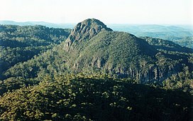
 Big Nellie Mountain, photographed from Little Nellie Mountain | |
| Highest point | |
| Elevation | 542 m (1,778 ft) AHD |
| Coordinates | 31°42′02″S 152°31′20″E / 31.700556°S 152.522222°E / -31.700556; 152.522222 |
| Geography | |
Location in
New South Wales,
Australia | |
| Location | Taree, New South Wales, New South Wales, Australia |
| Geology | |
| Age of rock | Miocene |
| Mountain type | Rhyolite [1] or Trachyte [2] |
Big Nellie Mountain is a volcanic plug in the Mid North Coast region of New South Wales, Australia. It is situated 272 kilometres (169 mi) northeast of Sydney, within Coorabakh National Park.
See also
References
- ^ "COORABAKH NATIONAL PARK DRAFT PLAN OF MANAGEMENT" (PDF). NSW National Parks and Wildlife Service. Retrieved 26 May 2018.
- ^ "Geological Sites of New South Wales, Lorne Basin, Lansdowne Escarpment and Big Nellie". Geomaps.com.au. Retrieved 26 May 2018.
| Coastal mountain ranges (not part of the Great Dividing Range) |
| ||||||||||||||||||||||||||
|---|---|---|---|---|---|---|---|---|---|---|---|---|---|---|---|---|---|---|---|---|---|---|---|---|---|---|---|
| Great Dividing Range |
| ||||||||||||||||||||||||||
| Inland mountain ranges |
| ||||||||||||||||||||||||||
| Island mountain ranges |
| ||||||||||||||||||||||||||
| Mountains not within a specific range | |||||||||||||||||||||||||||
|
| This New South Wales geography article is a stub. You can help Wikipedia by expanding it. |
Retrieved from "
https://en.wikipedia.org/?title=Big_Nellie_Mountain&oldid=1003706252"
