Photos • Location
Yongjia
永嘉县 Yungkia | |
|---|---|
 | |
| Coordinates: 28°09′14″N 120°41′29″E / 28.1539°N 120.6914°E | |
| Country | People's Republic of China |
| Province | Zhejiang |
| Prefecture-level city | Wenzhou |
| Township-level divisions | 8 subdistricts, 10 towns |
| Area | |
| • Total | 2,698 km2 (1,042 sq mi) |
| Elevation | 39 m (128 ft) |
| Population (2007) | |
| • Total | 886,300 |
| • Density | 330/km2 (850/sq mi) |
| Time zone | UTC+8 ( China Standard) |
| Area code | 0577 |
| Website | http://yongjia.org.cn |
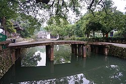
Yongjia County ( simplified Chinese: 永嘉县; traditional Chinese: 永嘉縣; pinyin: Yǒngjiā Xiàn; Wenzhou dialect: yon2ko1/ yu3 ion ko) is a county in Wenzhou in the southeast of Zhejiang province, People's Republic of China, located 15 kilometres (9.3 mi) north of the city proper of Wenzhou city, which administers the county. The Nanxi River Scenic Area is located within this county, and the river has been nominated on the tentative list of UNESCO World Heritage Sites.
Administrative divisions
Subdistricts of the Shangtang Administrative Committee (上塘管委会): [1]
- Beicheng Subdistrict (北城街道), Dongcheng Subdistrict (东城街道), Nancheng Subdistrict (南城街道)
Subdistricts of the Oubei Administrative Committee (瓯北管委会):
- Dong'ou Subdistrict (东瓯街道), Jiangbei Subdistrict (江北街道), Huangtian Subdistrict (黄田街道), Sanjiang Subdistrict (三江街道), Wuniu Subdistrict (乌牛街道)
Towns:
- Qiaotou (桥头镇), Qiaoxia (桥下镇), Shatou (沙头镇), Bilian (碧莲镇), Xunzhai (巽宅镇), Yantou (岩头镇), Fenglin (枫林镇), Yantan (岩坦镇), Daruoyan (大箬岩镇), Hesheng (鹤盛镇)
Climate
| Climate data for Yongjia (1991–2020 normals, extremes 1981–2010) | |||||||||||||
|---|---|---|---|---|---|---|---|---|---|---|---|---|---|
| Month | Jan | Feb | Mar | Apr | May | Jun | Jul | Aug | Sep | Oct | Nov | Dec | Year |
| Record high °C (°F) | 24.9 (76.8) |
29.0 (84.2) |
30.8 (87.4) |
34.5 (94.1) |
36.8 (98.2) |
38.9 (102.0) |
42.1 (107.8) |
39.4 (102.9) |
40.5 (104.9) |
36.6 (97.9) |
30.8 (87.4) |
26.0 (78.8) |
42.1 (107.8) |
| Mean daily maximum °C (°F) | 13.2 (55.8) |
14.7 (58.5) |
17.8 (64.0) |
23.0 (73.4) |
27.1 (80.8) |
30.0 (86.0) |
34.2 (93.6) |
33.7 (92.7) |
30.6 (87.1) |
26.4 (79.5) |
21.1 (70.0) |
15.9 (60.6) |
24.0 (75.2) |
| Daily mean °C (°F) | 8.5 (47.3) |
9.7 (49.5) |
12.6 (54.7) |
17.5 (63.5) |
22.0 (71.6) |
25.5 (77.9) |
28.9 (84.0) |
28.5 (83.3) |
25.6 (78.1) |
20.9 (69.6) |
16.0 (60.8) |
10.6 (51.1) |
18.9 (66.0) |
| Mean daily minimum °C (°F) | 5.3 (41.5) |
6.4 (43.5) |
9.3 (48.7) |
13.8 (56.8) |
18.5 (65.3) |
22.3 (72.1) |
25.2 (77.4) |
25.0 (77.0) |
22.1 (71.8) |
17.0 (62.6) |
12.5 (54.5) |
7.0 (44.6) |
15.4 (59.7) |
| Record low °C (°F) | −3.6 (25.5) |
−3.0 (26.6) |
−1.7 (28.9) |
3.6 (38.5) |
9.4 (48.9) |
13.7 (56.7) |
18.4 (65.1) |
19.4 (66.9) |
14.0 (57.2) |
6.0 (42.8) |
1.3 (34.3) |
−4.8 (23.4) |
−4.8 (23.4) |
| Average precipitation mm (inches) | 61.2 (2.41) |
80.2 (3.16) |
144.5 (5.69) |
137.6 (5.42) |
168.8 (6.65) |
270.6 (10.65) |
193.2 (7.61) |
291.7 (11.48) |
189.2 (7.45) |
71.1 (2.80) |
71.6 (2.82) |
56.9 (2.24) |
1,736.6 (68.38) |
| Average precipitation days (≥ 0.1 mm) | 12.2 | 13.6 | 17.8 | 16.4 | 16.9 | 18.6 | 14.4 | 17.3 | 12.7 | 8.0 | 10.5 | 10.2 | 168.6 |
| Average snowy days | 1.3 | 1.1 | 0.3 | 0 | 0 | 0 | 0 | 0 | 0 | 0 | 0 | 0.4 | 3.1 |
| Average relative humidity (%) | 73 | 75 | 77 | 77 | 78 | 83 | 78 | 79 | 76 | 72 | 74 | 72 | 76 |
| Mean monthly sunshine hours | 99.9 | 95.7 | 109.2 | 132.1 | 135.2 | 122.5 | 216.3 | 206.1 | 165.6 | 165.6 | 122.1 | 118.7 | 1,689 |
| Percent possible sunshine | 30 | 30 | 29 | 34 | 32 | 30 | 51 | 51 | 45 | 47 | 38 | 37 | 38 |
| Source: China Meteorological Administration [2] [3] | |||||||||||||
Transport
- Wenzhou North railway station (Under renovation)
References
- ^ 温州市-行政区划网 www.xzqh.org (in Chinese (China)). XZQH.org. Retrieved 2012-05-24.
- ^ 中国气象数据网 – WeatherBk Data (in Simplified Chinese). China Meteorological Administration. Retrieved 25 June 2023.
- ^ 中国气象数据网 (in Simplified Chinese). China Meteorological Administration. Retrieved 25 June 2023.
