Photos • Location

Wolthusen | |
|---|---|
 | |
Location of Wolthusen within Emden  | |
 Wolthusen  Wolthusen | |
| Coordinates: 53°22′17″N 7°13′35″E / 53.37129°N 7.22648°E | |
| Country | Germany |
| State | Lower Saxony |
| City | Emden |
| Population | |
| • Metro | 4,081 |
| Time zone | UTC+01:00 ( CET) |
| • Summer ( DST) | UTC+02:00 ( CEST) |
| Dialling codes | 04921 |
| Vehicle registration | 26725 |
Wolthusen is a former village in Lower Saxony, Germany and borough (Stadtteil) of Emden. It was incorporated into the city in 1928.
The village character can still be found around the old village church from 1784. The church, located on a yard, was built on the location where a predecessor had already been built in the fifteenth century. [1] The name of the village refers to its location in low, swampy meadows (wold), composed of -husen, i.e. 'houses'. [2]
Gallery
-
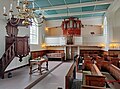 Interior of the church
 -
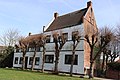 Hooge Hus ('High House')
.jpg)

References
- ^ "Evangelisch-reformierte Kirche Wolthusen". Reformiert.de (in German). Retrieved 17 October 2023.
- ^ Remmers, Arend (2004). Von Aaltukerei bis Zwischenmooren – Die Siedlungsnamen zwischen Dollart und Jade (in German). Leer: Verlag Schuster. p. 246. ISBN 3796303595.
External links
![]() Media related to
Wolthusen (Emden) at Wikimedia Commons
Media related to
Wolthusen (Emden) at Wikimedia Commons
|
| This Emden location article is a stub. You can help Wikipedia by expanding it. |