| Main page | Assessment | Bibliography | Image Database | Portal |
Wikimedia Commons has media related to
Submarine volcanoes.
Wikimedia Commons has media related to
Seamounts.
Wikimedia Commons has media related to
Bowie Seamount.
Generic
-
 Stylized SVG logo, by Resident Mario
 -
 Another version of the genric Seamount logo, also by Resident Mario
 -
 Lava explodes as ocean water covers the lava tube
 -
 Hotspot map
 -
 Useful Plate Tectonics reference image


Maps
-
 Trail of seamounts created by the Hawaii hotspot, known as the Hawaiian-Emperor seamount chain.
 -
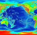 Uncropped version.
 -
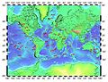
 Genral map showing location of all major seamounts of the world.
 -

-
 Map of submarine volcanoes on the coast of British Columbia.
 -

-
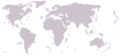
 Indonesia underwater volcano locator, used with next image to indicate locations:
 -
 See previous; useful location marker via z-index positioning.
 -

-

-
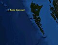
 Protector Shoal locator map
 -
-
 Juan de Fuca Ridge map showing the location of Axial Seamount
 -
 Juan de Fuca Ridge map showing the location of Axial Seamount
 -
 Cordell Bank National Marine Sanctuary map, with seamounts attached
 -
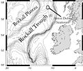
 X marks the spot of Ferdinandea, a Medditeranian seamount


Seamounts
-
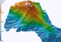
 3-D Pierce Seamount visualization
 -
 3-D Hodgkins Seamount visualization.
 -

-
 Aster satellite image of the new volcanic island called " Home Reef"
 -
 Kick 'em Jenny Seamount; see details on its page.
 -
 Underwater topography of Cordell Bank
 -
 Orca Seamount in the Bransfield Strait, Antarctic Peninsula.
 -
 Uploaded by Resident Mario in preparation for Orca Seamount article
 -


GAs/FAs
-
 Map of Bowie Seamount
 -
 3-D Bowie Seamount Depiction
 -
 Another 3-D Bowie Seamount, with Hodgkins Seamount in the background.
 -
 Bowie Seamount outline, showing its Marine Protected Area status.
 -
 Eastern Flank
 -
 Top view
 -
 Another view
 -
X marks the spot of Ferdinandea, a Medditeranian seamount
-
Artistic rendering of the 1831 Ferdinandea eruption
-
 French geologist's entry for Ferdinandea
 -
 Yellow iron oxide covered lava rock on the flank of Loihi
 -
 Bathemetric mapping of Loihi
 -
 3D Rendering of Loihi
 -

-
 Another view, with tracklines from the 2002 expedition.


Biota/Other
-
 Biota on the NE seamount chain
 -
 Pillow Lava, a type of lava originating from Seamounts.
 -

-
 Benthic octopus and clam on the Davidson Seamount at 1461 meters.
 -
Yellow rust covering lava rocks on Loihi Seamount


