The
Graphics Lab is a project to improve the graphical content of the Wikimedia projects. Requests for image improvements can be added to the workshop pages:
Illustrations,
Photographs and
Maps. For questions or suggestions one can use the talk pages:
Talk:Graphics Lab,
Talk:Illustrations,
Talk:Photographs and
Talk:Maps.
This specific page is the requests page for the Map workshop. Anyone can make a request for a map to be created or improved for a Wikipedia article. The standard format for making a request is shown below, along with general advice, and should be followed.
You are encouraged to share information and request advice from others. Also see
possible conventions toolbox,
map tutorials and
topographic map tutorials.
| Advice to requesters |
|---|
|
What do we do?
|


| If you have completed work and not received a reply you may use the {{ GL Map reply}} template to inform the requester. |
|
| Map makers and other visitors to the Graphics Lab may be interested in the RSS feed of changes to this page. You may find it here. |
| See also our sister Map workshop at Commons and the WikiProject Maps |
| Result | Code | Usage |
|---|---|---|
{{resolved|~~~~}}
|
Mark a thread as resolved and request archiving | |
{{subst:bump}}
|
Delay automatic archiving of a section for 30 days | |
|
|
{{I take|~~~~}}
|
When you'll be working on the request |
{{Done}} ~~~~
|
When the request is done |
|
|
This page is automatically archived by ClueBot III. |
| This page has a
backlog that requires the attention of willing editors. Please remove this notice when the backlog is cleared. |
-
 Percent of scheduled tribes in India by tehsils by census

- Article(s)
- List of Scheduled Tribes in India
- Request
- To make states and union territories boundaries more visible. Now it is almost same as for districts.--
Kaiyr (
talk)
16:30, 22 November 2023 (UTC)
- @ Kaiyr If the base map on Commons:file:Baiga distribution.svg has all the correct borders, you have to check and tell me!
- we can use that and make a new svg version of the one you want.
- To edit the present png file like you want is hard and for the future a svg version is so much better and easier to edit. --always ping me-- Goran tek-en ( talk) 12:12, 16 December 2023 (UTC)
- My map with tehsil level (subdistrict). Your map in district level. I think it is only differet. You can make this map in this site also
http://www.demographie.net/atlas2001/index.html --
Kaiyr (
talk)
14:06, 16 December 2023 (UTC)
- Unfortunately, the vast majority of people cannot, because modern web browsers removed support for Adobe Flash many years ago now. Remsense 留 14:57, 16 December 2023 (UTC)
- Ok. Lets try.-- Kaiyr ( talk) 16:00, 16 December 2023 (UTC)
- My map with tehsil level (subdistrict). Your map in district level. I think it is only differet. You can make this map in this site also
http://www.demographie.net/atlas2001/index.html --
Kaiyr (
talk)
14:06, 16 December 2023 (UTC)
- @
Kaiyr That link will not work for me. You have to help me here, I have zero knowledge about different divisions/levels in India.
- Have you checked what we have at commons regarding svg maps of India divided, check this category and all of its subcategories to see if you can find a better base map. --always ping me-- Goran tek-en ( talk) 16:06, 16 December 2023 (UTC)
- I have cheked. Everyting is ok. Kaiyr ( talk) 18:12, 18 December 2023 (UTC)
- @
Kaiyr That link will not work for me. You have to help me here, I have zero knowledge about different divisions/levels in India.
![]() Request taken by --always ping me--
Goran tek-en (
talk)
11:52, 19 December 2023 (UTC).
Request taken by --always ping me--
Goran tek-en (
talk)
11:52, 19 December 2023 (UTC).
Will be back with a draft. --always ping me--
Goran tek-en (
talk)
11:52, 19 December 2023 (UTC)
- @
Kaiyr I just want you to know I'm working on it but I have also been trying to find a vector map down to tehsils. I have now found a dataset which I'm converting to a usable svg which I can upload as a base map with the three different levels. We can then use that for your request and for future usage. So it will take some more time. --always ping me--
Goran tek-en (
talk)
13:20, 22 December 2023 (UTC)
- .So @ Kaiyr I now have a draft for you for the basemap down to tehsils.
- ----
- Those drafts are PNG versions of the original SVG file I'm working in and will upload to commons.
- Those drafts are shown for proofreading only.
- ----
- The colors are picked so that they work for most people even with color deficiencies.
- So check this basemap and let me know if it will work for you or what to edit,
Draft basemap-1. --always ping me--
Goran tek-en (
talk)
11:48, 28 December 2023 (UTC)
- @
Kaiyr I would need your feedback per above, thanks. --always ping me--
Goran tek-en (
talk)
15:17, 1 January 2024 (UTC)
- @ Kaiyr I haven't got any feedback so now I have uploaded the basemap down to tehsils which can be used to create other maps, as I will use it to do your request here now.
- You can find it here
Inda states districts tehsils by census 2011.
- Please check all the information, also links for wikipedia, wikidata and structured data.
- --always ping me--
Goran tek-en (
talk)
18:02, 7 January 2024 (UTC)
- @
Kaiyr I just want you to know I am working on your request. Your source map and the background map I'm using does not line up, also the tehsils are different in those maps and your source map has even smaller divisions in it. All of this makes it rather complex, difficult and circumstantial to create the svg map. But I have gotten a good bit on it and will continue, thanks for your patience. --always ping me--
Goran tek-en (
talk)
10:53, 12 January 2024 (UTC)
- @ Kaiyr
-
Now I have a Draft-1 for you to check. It was complex to redraw so really really check everything and give me feedback, thanks. --always ping me--
Goran tek-en (
talk)
15:27, 13 January 2024 (UTC)
- I cant see state borders.
Kaiyr (
talk)
15:45, 16 January 2024 (UTC)
- @ Kaiyr Please Always ping me, thanks.
-
New Draft-2 with states. --always ping me--
Goran tek-en (
talk)
12:44, 19 January 2024 (UTC)
- @ Kaiyr
- I haven't heard from you so I uploaded what I had. If you want anything edited just ping me, thanks.
- Now you can find it here
Commons:file:Percent of scheduled tribes in India-tehsils-census 2011.svg.
- Please check all the information, also links for wikipedia, wikidata and structured data.
- If you are happy with this please put the code
{{re.solved|~~~~}}(without the ".") on this request so it can be archived, thanks. Done
Done
- --always ping me--
Goran tek-en (
talk)
12:24, 27 January 2024 (UTC)
-
User:Goran tek-en Thank you very much. Could you add Andaman&Nicobar if aI upload here or send to you? Can we change per cent to more presice one? 20%, 40%, 60%,80%?
Kaiyr (
talk)
06:19, 9 February 2024 (UTC)
- @
Kaiyr Didn't see this until now, didn't get any ping, try the actual Ping
{{ping|Goran tek-en}}the next time. - Sure we can do that, send me the info I need, thanks. --always ping me--
Goran tek-en (
talk)
18:21, 18 February 2024 (UTC)
- @
Goran tek-en:. I have updated png file with 20%, 40%, 60%,80% and added andaman and nicobar islands.--
Kaiyr (
talk)
10:15, 8 April 2024 (UTC)
- @ Kaiyr
- Draft added-1.
- If any of the colored areas (other than the islands) has changed you will have to tell me which, thanks. --always ping me--
Goran tek-en (
talk)
15:00, 9 April 2024 (UTC)
- @
Kaiyr I do need your feedback to be able to continue, thanks. --always ping me--
Goran tek-en (
talk)
14:53, 23 April 2024 (UTC)
- I dont know which tehsils were changed. But I think only several. Kaiyr ( talk) 17:19, 18 May 2024 (UTC)
- @
Kaiyr I do need your feedback to be able to continue, thanks. --always ping me--
Goran tek-en (
talk)
14:53, 23 April 2024 (UTC)
- @
Goran tek-en:. I have updated png file with 20%, 40%, 60%,80% and added andaman and nicobar islands.--
Kaiyr (
talk)
10:15, 8 April 2024 (UTC)
- @
Kaiyr Didn't see this until now, didn't get any ping, try the actual Ping
-
User:Goran tek-en Thank you very much. Could you add Andaman&Nicobar if aI upload here or send to you? Can we change per cent to more presice one? 20%, 40%, 60%,80%?
Kaiyr (
talk)
06:19, 9 February 2024 (UTC)
- I cant see state borders.
Kaiyr (
talk)
15:45, 16 January 2024 (UTC)
- @
Kaiyr I just want you to know I am working on your request. Your source map and the background map I'm using does not line up, also the tehsils are different in those maps and your source map has even smaller divisions in it. All of this makes it rather complex, difficult and circumstantial to create the svg map. But I have gotten a good bit on it and will continue, thanks for your patience. --always ping me--
Goran tek-en (
talk)
10:53, 12 January 2024 (UTC)
- @
Kaiyr I would need your feedback per above, thanks. --always ping me--
Goran tek-en (
talk)
15:17, 1 January 2024 (UTC)
-
 Munda languages map

- Article(s)
- Munda languages
- Request
- Could you add District and subdistrict boundary? -- Kaiyr ( talk) 17:50, 18 May 2024 (UTC)
- Discussion

- Article(s)
- Any article this already features on.
- Request
- Would anybody be able to please redraw the above GIF map as SVG? Thanks.
Snow Lion Fenian (
talk) 13:15, 2 June 2024 (UTC)
 Bumping thread.
Snow Lion Fenian (
talk)
01:10, 2 July 2024 (UTC)
Bumping thread.
Snow Lion Fenian (
talk)
01:10, 2 July 2024 (UTC) - Discussion

- Article(s)
- Donald Trump 2016 presidential campaign
- Results of the 2016 Republican Party presidential primaries
- Request
- I saw this map on John Kasich 2016 presidential campaign, I was wondering can somebody make one for Donald Trump 2016 presidential campaign for his Republican primary Percentage of vote received by Trump by state or territory. Muaza Husni ( talk) 09:03, 5 June 2024 (UTC)
References
Here are the result numbers.
- Trump got 24% in Iowa,
- Trump got 35% in New Hampshire,
- Trump got 33% in South Carolina,
- Trump got 46% in Nevada,
- Trump got 43% in Alabama,
- Trump got 34% in Alaska,
- Trump got 33% in Arkansas,
- Trump got 39% in Georgia,
- Trump got 49% in Massachusetts,
- Trumo got 21 in Minnesota,
- Trump got 28% in Oklahoma,
- Trump got 39% in Tennessee,
- Trumo got 27% in Texas,
- Trump got 32% in Vermont,
- Trump got 35% in Virginia,
- Trump got 23% in Kansas,
- Trump got 36% in Kentucky,
- Trump got 41% in Louisiana,
- Trump got 33% in Maine,
- Trump got 13% in Puerto Rico,
- Trump got 43% in Hawaii,
- Trump got 28% in Idaho,
- Trump got 37% in Michigan,
- Trump got 37% in Mississippi,
- Trump got 7% in Wyoming,
- Trump got 46% in Florida,
- Trump got 39% in Illinois,
- Trump got 41% in Missouri,
- Trump got 40% in North Carolina,
- Trump got 36% in Ohio,
- Trump got 46% in Arizona,
- Trump got 14% in Utah,
- Trump got 35% in Wisconsin,
- Trump got 59% in New York,
- Trump got 58% in Connecticut,
- Trump got 61% in Delaware,
- Trump got 54% in Maryland,
- Trump got 57% in Pennsylvania,
- Trump got 63% in Rhode Island,
- Trump got 53% in Indiana,
- Trump got 61% in Nebraska,
- Trump got 77% in West Virginia,
- Trump got 64% in Oregon,
- Trump got 75% in Washington,
- Trump got 75% in California,
- Trump got 74% in Montana,
- Trump got 80% in New Jersey,
- Trump got 71% in New Mexico,
- Trump got 67% in South Dakota.
Muaza Husni ( talk) 07:54, 25 June 2024 (UTC)

-
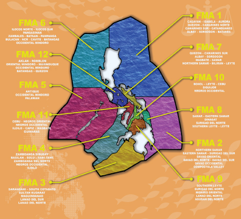
 Png of EEZ, note the extension on the northeast which was made after the Fisheries Management Law not in the external links below.

- Article(s)
- Fisheries management
- Request
- In 2019 the Philippines divided its waters into 12 "Fisheries Management areas", covering both its territorial waters and its exclusive economic zone. There are some good maps of the original 12 out there eg. and eg., but not to my knowledge one on Wikipedia. I am not even sure we have an svg of the EEZ, the standard image we use is the png above. One interesting note on that png is it includes the Benham Rise, which was annexed after the creation of the FMAs. Supposedly this area got its own FMA, and while I can't find a map of that or the primary legislatoin it likely should be labelled separately, perhaps as "Philippine Rise". An svg would be best due to this, for easy modification of the label. As for the original 12, the legislation is Fisheries Administrative Order 263 which includes the precise borders of all 12 areas by latitude and longitude. CMD ( talk) 09:16, 9 June 2024 (UTC)
- Discussion
- There seems to be KML data here but as the FoI portal is undergoing maintenance it is currently inaccessible. – Isochrone ( talk) 16:37, 21 June 2024 (UTC)
-
 Description of first image
 -
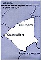

- Article(s)
- Dolly Johnson
- Request
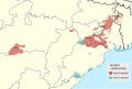
- Hoping for a map that shows the location of Greeneville within Greene County, but that also puts Greene County's location in East Tennessee and nearby states (namely Virginia and North Carolina), to be illustrative for people who may be unfamiliar with American geography. Might want to include Knoxville and Parrotsville as well, as other key cities in Dolly's bio. TY! -- jengod ( talk) 16:28, 13 June 2024 (UTC)
- Discussion
-
 Current map

Article(s)
Request
- Requesting a new range map for the lion based on the 2023 IUCN Redlist map here
LittleJerry ( talk) 01:51, 26 June 2024 (UTC)
-
 The current map, outdated to 2021.

- Article(s)
- List of PDC World Cup of Darts teams
- Request
- Requesting someone who knows how to do this sort of thing to update the map on List of PDC World Cup of Darts teams, last updated in 2021. The specific changes that are required are for New Zealand, Latvia, Switzerland, France, Malaysia, Guyana, Iceland, Taiwan, Norway, Bahrain and Croatia to be coloured light blue and for Ukraine, Russia, Brazil and Greece to be coloured in orange. This will match with developments over the 2022, 2023 and 2024 tournaments and will match the key on the article. -- OZOO (t) (c) 13:48, 1 July 2024 (UTC)
- Discussion
-
 Original

- Article(s)
- Postal code
- Request
- Is it possible to make the United states striped in the colors for 5 and 9? Both lengths of ZIP codes are commonly used in the US. Some other countries on the map have different length postcodes as well but only for certain regions or special purposes while in the US one can basically choose which one to use. -- 188.23.202.105 ( talk) 17:20, 6 July 2024 (UTC)
- Discussion