Photos • Location

| Wedge Peak | |
|---|---|
 | |
| Highest point | |
| Elevation | 9,941 ft (3,030 m) |
| Coordinates | 63°12′11″N 150°30′34″W / 63.20306°N 150.50944°W [1] |
| Geography | |
 Wedge Peak Alaska | |
| Location | Denali Borough, Alaska, United States |
| Parent range | Alaska Range |
| Topo map | USGS Mount McKinley A-2 |
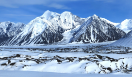
Wedge Peak is a 9,941-foot (3,030 m) mountain in the Alaska Range, in Denali National Park and Preserve. Wedge Peak lies to the northeast of Denali overlooking Brooks Glacier and Muldrow Glacier. Mount Mather (Alaska) is immediately to the east. The peak was named in 1945 by the U.S. Army Air Force cold weather test expedition. [2] [1]
- ^ a b "Wedge Peak". Geographic Names Information System. United States Geological Survey, United States Department of the Interior. Retrieved 2013-04-17.
- ^ "Wedge peak". Bivouac.com. Retrieved 2013-04-17.