Photos • Location


Villafans | |
|---|---|
 The town hall in Villafans | |
 Villafans  Villafans | |
| Coordinates: 47°34′55″N 6°28′21″E / 47.5819°N 6.4725°E | |
| Country | France |
| Region | Bourgogne-Franche-Comté |
| Department | Haute-Saône |
| Arrondissement | Lure |
| Canton | Villersexel |
| Area 1 | 6.44 km2 (2.49 sq mi) |
| Population (2021)
[1] | 204 |
| • Density | 32/km2 (82/sq mi) |
| Time zone | UTC+01:00 ( CET) |
| • Summer ( DST) | UTC+02:00 ( CEST) |
| INSEE/Postal code |
70552 /70110 |
| Elevation | 263–361 m (863–1,184 ft) |
| 1 French Land Register data, which excludes lakes, ponds, glaciers > 1 km2 (0.386 sq mi or 247 acres) and river estuaries. | |
Villafans is a commune in the Haute-Saône department in the region of Bourgogne-Franche-Comté in eastern France.
Coal mines were operated in the village between 1828 and 1916. [2]
-
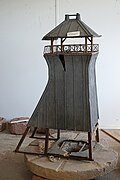 Mine shaft headframe 15 model.
 -
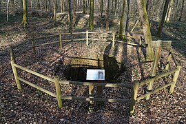 Mine shaft 15 site.


See also
References
- ^ "Populations légales 2021" (in French). The National Institute of Statistics and Economic Studies. 28 December 2023.
- ^ Pierre Semonin, Le gîte houiller de Villafans, 1993
Wikimedia Commons has media related to
Villafans.
| Authority control databases: National |
|---|
|
| This Haute-Saône geographical article is a stub. You can help Wikipedia by expanding it. |