Photos • Location
The
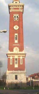
Torre Ader, a city landmark since 1917.

This article needs additional citations for
verification. (December 2014) |
Villa Adelina | |
|---|---|
District | |
.jpg) May Avenue, Villa Adelina. | |
 Villa Adelina Location in
Greater Buenos Aires | |
| Coordinates: 34°31′S 58°32′W / 34.517°S 58.533°W | |
| Country | |
| Province | |
| Partido | |
| Founded | 1909 |
| Named for | Adelina Munro Drysdale |
| Elevation | 26 m (85 ft) |
| Population | |
| • Total | 44,587 |
| CPA Base | |
| Area code | + 54 11 |
Villa Adelina is a city in Buenos Aires Province, Argentina. It is divided between the counties ( partidos) of San Isidro and Vicente López and forms part of the urban conurbation of Greater Buenos Aires. The town is named after Adelina Munro Drysdale, whose grandfather was a British railway official in Argentina.
Education
|
| This section needs expansion. You can help by
adding to it. (March 2016) |
The area once had a German school, Deutsche Schule Villa Adelina. [1]
References
- ^ " Deutscher Bundestag 4. Wahlperiode Drucksache IV/3672" ( Archived 12 March 2016 at the Wayback Machine). Bundestag (West Germany). 23 June 1965. Retrieved on 12 March 2016. p. 16/51.
External links

- (in Spanish) La Página de Villa Adelina - Ciudad Villa Adelina
| National | |
|---|---|
| Geographic | |
|
| This article about a place in Buenos Aires Province, Argentina is a stub. You can help Wikipedia by expanding it. |