Valik Chal
وليك چال | |
|---|---|
village | |
 Valik Chal | |
| Coordinates: 36°05′51″N 53°13′02″E / 36.09750°N 53.21722°E | |
| Country | |
| Province | Mazandaran |
| County | Sari |
| Bakhsh | Dodangeh |
| Rural District | Banaft |
| Population (2006) | |
| • Total | 67 |
| Time zone | UTC+3:30 ( IRST) |
| • Summer ( DST) | UTC+4:30 ( IRDT) |
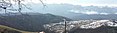
Valik Chal ( Persian: وليک چال, also Romanized as Valīk Chāl) [1] is a village in Banaft Rural District, Dodangeh District, Sari County, Mazandaran Province, Iran. At the 2006 census, its population was 67, in 15 families. [2] Valik Chal has views of Alborz Mountain Range and nearby forests. Due to its high altitude ( Height above mean sea level: approximately 1500 meters≈5000 feet), Valik Chal experiences relatively cool summers.[ citation needed] Winters can be cold and snowy with much rain. Valik Chal has been named after 'Valik', the local word for the fruit ' elderberry', which naturally grows in this village, and 'Chal' the local word for 'valley'. The people of Valik Chal are mainly farmers and ranchers raising crops and cattle.[ citation needed]
-
 روستای ولیک چال
 -
 منظره ی زیبایی از روستای ولیک چال
 -
 منظره ی زیبایی از روستای ولیک چال
.jpg)

- ^ Valik Chal can be found at GEOnet Names Server, at this link, by opening the Advanced Search box, entering "-3837729" in the "Unique Feature Id" form, and clicking on "Search Database".
- ^ "Census of the Islamic Republic of Iran, 1385 (2006)" (Excel). Statistical Center of Iran. Archived from the original on 2011-09-20.
|
| This Sari County location article is a stub. You can help Wikipedia by expanding it. |