Photos • Location
| Valbona | |
|---|---|
 Valbona river | |
| Location | |
| Country | Albania |
| Physical characteristics | |
| Source | Albanian Alps |
| • coordinates | 42°24′40″N 19°52′41″E / 42.411°N 19.878°E |
| Mouth | |
• location | Lake Koman |
• coordinates | 42°16′01″N 20°01′23″E / 42.267°N 20.023°E |
| Length | 50.6 km (31.4 mi) |
| Basin size | 657 km2 (254 sq mi) |
| Basin features | |
| Progression | Drin→ Adriatic Sea |
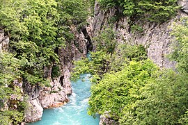
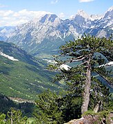
The Valbona ( Albanian: Valbonë) is a river in northern Albania. It is still relatively untouched. Its source is in the Accursed Mountains, near the border with Montenegro.
The Valbonë flows generally east through the municipality Margegaj (mountain villages Valbonë, Dragobi and Shoshan), then turns south along Bajram Curri, and continues southwest until its outflow into the river Drin, near Fierzë. It is one of the cleanest rivers in the country. The river begins in and flows through the Valbonë valley.
Gallery
See also
References


