Photos • Location
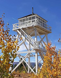
Ute Mountain Fire Tower | |
 Ute Mountain Fire Tower, September 2018 | |
| Location |
Daggett County,
Utah United States |
|---|---|
| Nearest city | Manila |
| Coordinates | 40°52′18″N 109°47′31″W / 40.87167°N 109.79194°W |
| Area | 1 acre (0.40 ha) |
| Built | 1937 |
| Architect | Civilian Conservation Corps |
| NRHP reference No. | 80003895 [1] |
| Added to NRHP | April 10, 1980 |
The Ute Mountain Fire Tower is a fire lookout tower in the Ashley National Forest in western Daggett County, Utah, United States, southwest of Manila, that is listed on the National Register of Historic Places. [1]
Description
The tower was built in 1937 and was added to the National Register of Historic Places on April 10, 1980. [2]
See also
References
- ^ a b "National Register Information System". National Register of Historic Places. National Park Service. March 13, 2009.
- ^ McFadden, Tish (April 1979). "National Register of Historic Places Nomination: Ute Mountain Fire Tower" ( PDF). nps.gov. National Park Service. "Accompanying 2 photos, from 1979" ( PDF). National Register of Historic Places Inventory.
External links
![]() Media related to
Ute Mountain Fire Tower at Wikimedia Commons
Media related to
Ute Mountain Fire Tower at Wikimedia Commons
Categories:
- Park buildings and structures on the National Register of Historic Places in Utah
- Government buildings completed in 1937
- Towers completed in 1937
- Buildings and structures in Daggett County, Utah
- Civilian Conservation Corps in Utah
- Fire lookout towers in Utah
- Fire lookout towers on the National Register of Historic Places
- National Register of Historic Places in Daggett County, Utah
- Utah Registered Historic Place stubs


