Hello, DLommes, and welcome to Wikipedia! Thank you for your contributions. I hope you like the place and decide to stay. Here are a few links to pages you might find helpful:
- Getting Started
- Introduction to Wikipedia
- The five pillars of Wikipedia
- How to edit a page and How to develop articles
- How to create your first article
- Simplified Manual of Style
Please remember to
sign your messages on
talk pages by typing four
tildes (~~~~); this will automatically insert your username and the date. If you need help, check out
Wikipedia:Questions, ask me on my talk page, or ask your question on this page and then place {{help me}} before the question. Again, welcome!
DES
(talk)
18:15, 17 November 2013 (UTC)
Thanks for doing the map for me, much appreciated. It looks good and I would like you to do the same for the rest. -- Dendro†Naja Talk to me! 19:04, 28 March 2014 (UTC)
- Again, thank you. I would like you to please do the map for Naja naja. That article is going to be improved and nominated for GA by me soon, so it's important that i hacve the map. Thanks. -- Dendro†Naja Talk to me! 19:51, 28 March 2014 (UTC)

You can remove this notice at any time by removing the {{Talkback}} or {{Tb}} template.
— Ahnoneemoos ( talk) 00:38, 29 March 2014 (UTC)
You can remove this notice at any time by removing the {{Talkback}} or {{Tb}} template.
— Ahnoneemoos ( talk) 14:01, 29 March 2014 (UTC)
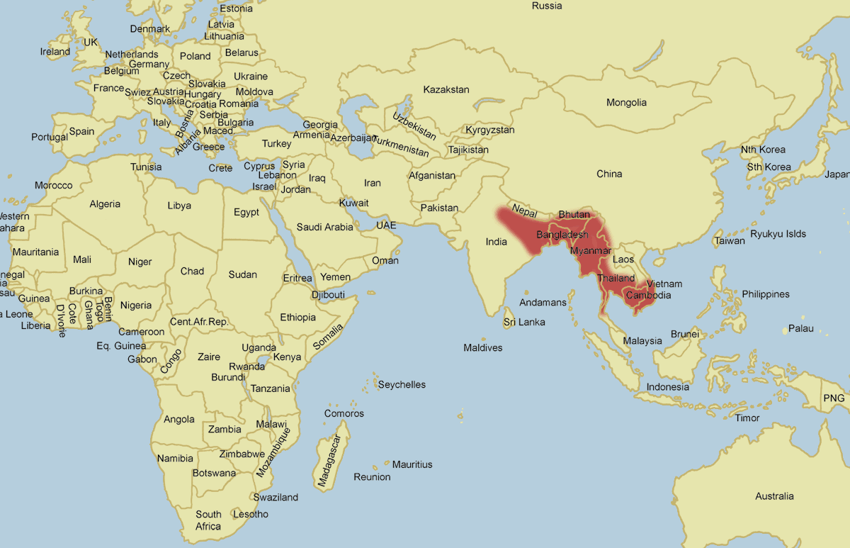
Hey, sorry I gave the link to the wrong map. Use this map here for the distribution of N. kaouthia.
You can remove this notice at any time by removing the {{Talkback}} or {{Tb}} template.
— Ahnoneemoos ( talk) 15:16, 29 March 2014 (UTC)
- Thanks a lot! Just forgot to request one more without any district highlighted. Can you have a look again please? — Ahnoneemoos ( talk) 15:31, 29 March 2014 (UTC)
Hello. I have posted the instructions here. I would dare to make a humble suggestion: Instead of uploading multiple versions of the same map on wikipedia, host your draft map on some site like photobucket.com, and once the draft reaches its final form then upload it on Wikipedia. There will be many tweaks and enhancements along they way; uploading a version to show each tweak is not an efficient way. Thanks. -- Fasi100 ( talk) 16:22, 29 March 2014 (UTC)
- I have posted the instructions for Indo-Scythian map. Please refresh the page to get the latest edits.
/info/en/?search=Wikipedia:Graphics_Lab/Map_workshop#Indo-Scythian. Thanks. --
Fasi100 (
talk)
22:23, 30 March 2014 (UTC)
- Please refresh the page to get latest edits: /info/en/?search=Wikipedia:Graphics_Lab/Map_workshop#Indo-Scythian -- Fasi100 ( talk) 12:39, 4 April 2014 (UTC)
- I have posted the instructions for Indo-Scythian map. Please refresh the page to get the latest edits.
/info/en/?search=Wikipedia:Graphics_Lab/Map_workshop#Indo-Scythian. Thanks. --
Fasi100 (
talk)
22:23, 30 March 2014 (UTC)
Hey, thanks for all the maps you made for me, again. I need one more. This is for a FA candidate article, so it's important. Please use this map here to make the map for me. Thanks! -- Dendro†Naja Talk to me! 12:34, 30 March 2014 (UTC)
You can remove this notice at any time by removing the {{Talkback}} or {{Tb}} template.
— Ahnoneemoos ( talk) 16:10, 30 March 2014 (UTC)
You can remove this notice at any time by removing the {{Talkback}} or {{Tb}} template.
— Ahnoneemoos ( talk) 16:43, 30 March 2014 (UTC)

|
The Tireless Contributor Barnstar | |
| For tireless contributions in Wikipedia Map Workshop. Fasi100 ( talk) 23:49, 3 April 2014 (UTC) |
Hi there, I have reformatted a couple of the section headings where you have used bold tags in the section headings. The convention has been to use the {{ stale}}, {{ resolved}} and {{ not done}}templates as these are supposed to be picked up by a bot, which then auto archives the section after a preset time. I will investigate why the bot doesn't appear to be functioning but in the mean time please stick to the established practice. Cheers, ► Philg88 ◄ ♦ talk 14:40, 4 April 2014 (UTC)
- @ Philg88: If they are auto-archived, then everything is fine. I just started this to keep an overview. Before i archived all the old stuff yesterday (or was it the day before) the list was exceedingly long and it was useful to get an overview what was already done. Cheers! -- DLommes ( talk) 15:02, 4 April 2014 (UTC)
- Thanks for the super speedy reply :) Yes, it can get a bit long - the rule of thumb seems to be leave requests for a month whatever the outcome and then move them to the archive. In the mean time I will see if I can get the bot restarted. Best, ► Philg88 ◄ ♦ talk 15:09, 4 April 2014 (UTC)
Can you look at Wikipedia:Graphics_Lab/Map_workshop#Iowa_senate_districts? I've had no response after 2 weeks. CTF83! 10:13, 17 April 2014 (UTC)
- @ CTF83! Alt,@ CTF83! yes, of course, i have seen it. but it looks like it is a lot of work, and (for non-iowans) rather boring, uninteresting work. so, to be frank, i don't see myself doing it. sorry. perhaps i'll change my mind later, but at the moment.. no. cheers!-- Lommes ( talk) 18:55, 18 April 2014 (UTC)
I'm no expert either, it was just good to see what seemed like an explanatory image in the lede, instead of an unclear still of a confusing video. Ask people on the talk page, I guess. -- McGeddon ( talk) 12:40, 15 July 2014 (UTC)
Hi there,
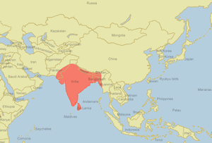
Your map for Daboia russelii is wrong. It doesn't show some of the countries where the snake is found. Please remove the incomplete map from the Wiki entry. Thanks.
Vern Lovic info@thailandsnakes.com
Thank you for creating and providing it. As with any representation of facts, if I were to use it as a reference I would want to know that the person who created it: - has access to accurate and complete data, - can detect flaws and errors in data sources, - is well equipped to evaluate and comprehend the data, - doesn't have "hidden" political or other agendas (source credibility), and - has the expertise needed to convey the data accurately (in this case, visually).
Especially as you said you've changed your user name more than once on wikipedia, I'm interested to know whether you're willing to share any information about yourself that would give reassurances about these five criteria.
Thank you for helping to make Wikipedia a great resource.
69.71.180.127 ( talk) 02:09, 19 July 2015 (UTC)F
- You are welcome, but I have to admit I have made so many maps, I am somewhat at a loss to get which one you are referring to. Could you give me a link to the Fabulous map showing Earth's population densities ?? Cheers. Lommes ( talk) 11:02, 20 July 2015 (UTC)
Hello Lommes, I had a question, could you please perhaps update this map you created some time ago, with two references written by historians that I will link here? I know it was made back then in the graphics-lab upon request (without any source), but the article is still unfortunately a mess ever since (like 2011?) so I thought of bringing in some references. The territories of the Indo-Parthians need some tweaking, with; the western border set at Nimruz Province, as well as Herat, the northern borders comprising Kabul and Bagram, the eastern border at minor parts of Punjab, India, while the southern border at Kandahar and the mouth of the Indus River; basically, spread mostly at Afghanistan and Pakistan, with a little bit of territoriy in contemporary northwestern India. Here are the references as well, which you can add on commons --> [1] [2]
Could you perhaps ping me upon reply, finishing the map, etc (e.g any reaction)? Thanks and bests :) - LouisAragon ( talk) 04:03, 5 November 2015 (UTC)
Hello Lommes, Thank you for uploading a vector file (File: Belt-road-forum-logo.svg), I have been concerned about the upload of this document, very grateful! Recently, I suddenly found that the picture file for some reason was deleted, which makes me feel puzzled and angry. At this point, I firmly support the reasons for your statement. Now that I have a request and idea: I hope you can send me this picture file and I need to make a design. Looking forward to your help and support! My e-mail: 980096751@qq.com Greatful! Sincerely.
Looking forward to your reply. XRAY96 ( talk) 03:11, 25 June 2017 (UTC)
Hi, I've noticed you incorrectly refer to the Extinction Symbol as the 'Extinction Rebellion Logo'. I created the symbol in 2011, 7 years before Extinction rebellion was formed, and it was being widely used globally since then. Extinction Rebellion are using it under agreement. The symbol is copyrighted, but is free for anyone to use on a strictly non-commercial basis. Therefore the licensing info you put on the page is also incorrect. If you require more info please see www.extinctionsymbol.info or email x@extinctionsymbol.info Thanks. — Preceding unsigned comment added by 150.143.118.79 ( talk) 19:19, 8 February 2019 (UTC)
- @ 150.143.118.79 Thank you for your message. I simply took an image that was already on wikimedia commons and converted it to svg. I have referred your request to the appropriate channels, that is the Copyright section of Village Pump (see Commons:Village_pump/Copyright#File:Extinction_Rebellion_Logo.svg_-_Is_PD-shape_appropriate?), where I have given all the information I have, and where the community will discuss your request. Unfortunately I do not currently feel able to see this through. All the best Lommes ( talk) 01:13, 9 February 2019 (UTC)
I noticed that two of your maps; /info/en/?search=User:Lommes#/media/File:Stoning-in-law.svg and /info/en/?search=Cultural_homogenization#/media/File:Major-Cultural-spheres.svg
omit the existence of the island of Cyprus. Is this intentional?
- i can guarantee that was not intentional. i have been known to quarrel with others about the status of some islands, but cyprus is not one of them (even tho there are things to quarrel about). in any case, i would never just leave the island out. this is either a problem with the original map i used, or something happened while copying the vectors... Thanks for notifying me, but afaik both maps are no longer in use. Cheers! -- Lommes ( talk) 18:02, 9 July 2022 (UTC)

|
The Original Barnstar |
| Good vectors Matias La Mota ( talk) 02:36, 18 February 2021 (UTC) |
I see there's a discussion on changing my Ontario Line map due to a lack of geographical placing. Is that even an issue? Its a example of the system maps shown at stations and on trains, which don't stress geographical placing. Transportfan70 ( talk) 17:24, 9 December 2022 (UTC)
Hi!
I wanted to know if you would be able to help my
WikiProject Asian Australians proposal by contributing a map.svg for the project. Similar to
File:WikiProject Asian Americans map.svg. This new map will also be used
here replacing of the Australian flag.
Let me know if you are interested or not. You don't have to support the project proposal, I just don't know how to create svg graphics and saw your amazing work.
Thanks,
AverageFraud (
talk)
16:13, 19 May 2023 (UTC)
- Never mind, I figured it out. AverageFraud ( talk) 09:39, 20 May 2023 (UTC)
Hello! Voting in the 2023 Arbitration Committee elections is now open until 23:59 (UTC) on Monday, 11 December 2023. All eligible users are allowed to vote. Users with alternate accounts may only vote once.
The Arbitration Committee is the panel of editors responsible for conducting the Wikipedia arbitration process. It has the authority to impose binding solutions to disputes between editors, primarily for serious conduct disputes the community has been unable to resolve. This includes the authority to impose site bans, topic bans, editing restrictions, and other measures needed to maintain our editing environment. The arbitration policy describes the Committee's roles and responsibilities in greater detail.
If you wish to participate in the 2023 election, please review
the candidates and submit your choices on the
voting page. If you no longer wish to receive these messages, you may add {{
NoACEMM}} to your user talk page.
MediaWiki message delivery (
talk)
00:43, 28 November 2023 (UTC)
Hi, what do the two colors on this map represent? I saw yours is based on an older PNG but didn’t see any info there either. I’m new to Wikipedia so maybe I missed it. I think there should be a legend/caption, otherwise it should just be one color.
Right now it’s a little confusing, I came from the English Herzegovina page which just says “Approximate region of Herzegovina” under the image. Thanks
https://commons.m.wikimedia.org/wiki/File:Herzegovina_location_map_simple.svg 64.98.31.14 ( talk) 15:01, 26 January 2024 (UTC)
- this has been created over 6 years ago. i have literally no memory of this whatsoever. i am sorry, but i can't help you. cheers, Lommes ( talk) 13:38, 29 January 2024 (UTC)
- ^ Dani, Ahmad Hasan. History of Civilizations of Central Asia: The development of sedentary and nomadic civilizations: 700 B.C. to A.D. 250 Motilal Banarsidass Publ., 1999 ISBN 978-8120814080 p 196
- ^ Rosenfield, John M. The Dynastic Arts of the Kushans (Photographic reference; figures 278–279) University of California Press, 1967