Maps
-
 Singapore outline
 -

-
 Urban Redevelopment Authority planning areas
 -

-
 Mass Rapid Transit, rail map
 -

-
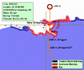 Hurricane Katrina,
This map was updated 8 times on 29 August 2005, tracking the path of Katrina as it made its landfall. It remained on the main article for several days. -


For more Singapore locator maps, see:
Photographs
-

-

-

-

-
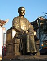 Sun Yat-sen sculpture


Simple labelling
-
 Different regions of the vertebral column
 -
 Fingernail parts

