
| Hameldon | |
|---|---|
 Hameldon viewed from
Read Hall Park | |
| Highest point | |
| Elevation | 408.7 m (1,341 ft) |
| Prominence | 107 m (351 ft) |
| Parent peak | Freeholds Top |
| Listing | Hump |
| Coordinates | 53°45′23″N 2°18′49″W / 53.7563°N 2.3137°W |
| Geography | |
 Hameldon Location in Lancashire | |
| Location |
Lancashire, |
| Parent range | Pennines |
| OS grid | SD79412892 |
| Topo map | OS Explorer 287 |
Hameldon Hill is a Carboniferous sandstone hill with a summit elevation of 409 metres (1,342 ft), situated between the towns of Burnley and Accrington in Lancashire, England. It is listed as a "HuMP" or "Hundred Metre Prominence", its parent being Freeholds Top, [a] a Marilyn near Bacup. [1]
Other nearby settlements include Hapton and hamlets of Clowbridge and Dunnockshaw in Burnley district, Huncoat and Baxenden in Hyndburn, and Crawshawbooth, Goodshaw and Loveclough in Rossendale.
History
The name Hameldon is used for two others in the local area and possibly the same as Hambledon Hill in Dorset. [b] The second element is likely Old English dūn meaning hill, the first is possibly from hamelian meaning to mutilate or maim. The precise meaning in these cases is uncertain, but possibly relates to their appearance. [2]
Huncoat, on the northern slope, is one of the few places mentioned in the brief details of the Blackburnshire hundred in the Domesday Book, with King Edward holding two carucates of land here. [3]
There may have been a deer park in neighbouring Hapton as early as 1330. Sir John Towneley obtained the first of two licenses to impark land there in 1496-1497. [4] After the King's commissioners re-let the Forest of Rossendale to local farmers in 1507, Towneley in 1514 enlarged his deer park to embrace 1100 Lancashire acres (2,000 acres (810 ha)) [5] making it the second largest in historic Lancashire after that of the Earl of Derby at Knowsley. [6] It covered much of the western part of the hill. [7] By 1615 deer were no longer kept in the park, though it was not divided into the present-day farms until the early the 18th century. [4]
Considered part of the Burnley Coalfield, Cupola Colliery mined coal from a number of shafts on the top of the hill, and was already established by the mid-1840s. The colliery was abandoned at the end of 1887 and the site subsequently cleared. The embankment created for its surface tramway can still be traced. [7] [8]
An number of smaller quarries at Hameldon Scouts had grown by 1886 into the Hameldon Quarries, when Henry Heys and Co took over the operation. It supplied large quantities of flagstones for the construction of mills in Burnley and Padiham. At that time tram roads connected the main site to another at Snipe Rake and to a facility at Park Gate Farm. These quarries ceased operation in 1909, but extensive remains still exist. [9]
During World War II a network of Starfish site bombing decoys where constructed in the area designed to protect Accrington. Two of the sites are on Hameldon, one near Heights Farm, and the other on the western side overlooking the town. [10] [11] The Heights Farm site is protected as a Scheduled monument. [12]
The Met Office north west England weather radar is situated on Hameldon Hill. Commissioned in 1975 this was the first unmanned installation of the 15 that form the national weather radar network. [13] Nearby are a number of communication masts including one that broadcasts BBC Radio Lancashire. [14] [15]
Hameldon Hill Wind Farm, located on the northern side of the hill, became operational in 2007. Initially consisting of three turbines, a further three were added around 2012. [16]
Geography
Hameldon has two summits, the highest point is known as Great Hameldon and attains 1,343 feet (409 m). To the east the ground falls slightly before gradually rising to 1,305 feet (398 m) at a point known simply as Hameldon. To the south of Great Hameldon, the hill gives-out a spur of child peaks, terminating at Cribden Hill near Haslingden. At the eastern end are Black, Nutshaw, Burnt hills. [17] [14]
The underlying geology of the area consists of Lower Westphalian coal measures of the Carboniferous era, while the hills are formed of Carboniferous sandstones, ranging from millstone grits to finer grained stone such as the Dyneley Knott flags and the Dandy Mine Rock. The drift cover consists primarily of glacial till deposits, which cause poor-drainage soils, meaning the grassland is prone to reed growth. [18]
On the northern slopes Castle Clough Brook runs north through a significant valley to join the River Calder, and both Shorten and Clough Brooks, further west, also drain the lower parts of the hill. On the eastern side New Barn Clough also flows north to join Habergham Brook, which along with Hapton Clough forms Green Brook at Spa Wood. In the centre a number of small streams combine to form Shaw Brook, which flows on the eastern side of Hapton and joins Green Brook just before its confluence with the Calder in Padiham. [17] [14]
On the western side Warmden Brook forms to the south of the Great Hameldon summit, feeding the Mitchell's House Reservoirs and becoming Broad Oak Water after it collects the stream from Tag Clough. Pleck Brook drains the area to the north, where several smaller reservoirs have also been created, and like Broad Oak Water joins the River Hyndburn in Accrington and ultimately the Calder. [19] [20] The southern slopes are primarily drained by three streams, one falls through Bank Clough in the east, and the others through Whin Hill and Great Cloughs in the west. All join Limy Water, a tributary of the River Irwell. [14]
The Burnley Way passes over the hill, following the old road from Hapton to Haslingden as it climbs Hameldon, before descending to Clow Bridge. [21]
Media gallery
-
 Trig point at the summit with Pendle Hill in the background.
 -
 Met Office north-west England weather radar on Hambledon Hill.
 -
 Archaeological excavation at the site of Hapton Tower.
 -
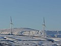 Two of the Hameldon Hill Wind Farm turbines in the winter of 2008.
 -
 Old quarry workings at Hameldon Scouts.
 -
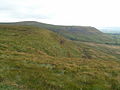 Looking towards Great Hameldon from Hameldon.


See also
References
Notes
- ^ Freeholds Top 53°41′36″N 2°08′38″W / 53.6933°N 2.1438°W
- ^ Black Hameldon 53°45′47″N 2°07′43″W / 53.763°N 2.1285°W and Hameldon Pasture 53°47′22″N 2°10′03″W / 53.7895°N 2.1675°W
Citations
- ^ Jackson, Mark (2009). "Carlisle to the Ribble and the Aire". More Relative Hills of Britain (PDF). p. 141. Archived from the original (PDF) on 13 September 2015. Retrieved 23 May 2021.
- ^ Ekwall, Eilert (1922). The place-names of Lancashire. Manchester University Press. pp. 10, 67–68. OCLC 82106091. Retrieved 26 May 2021.
- ^ "Domesday Book Online". domesdaybook.co.uk. Retrieved 26 May 2021.
- ^ a b Whitaker, Thomas Dunham (1876). An history of the original Parish of Whalley, and honor of Clitheroe... Vol. 2 (4th ed.). George Routledge. pp. 58, 64. OCLC 697798990. Retrieved 26 May 2021.
- ^ Hapton Heritage - A Landscape History and Village Survey, Bluestone Archaeology, 2013, pp. 4, 17
- ^ Tracing the Towneleys (PDF). Towneley Hall Society. 2004. p. 8. Archived from the original (PDF) on 4 August 2017. Retrieved 26 May 2021.
- ^ a b Lancashire and Furness (Map). 1 : 10,560. County Series. Ordnance Survey. 1848.
- ^ Nadin, Jack (1997), British Mining No. 58 The Coal Mines of East-Lancashire, Northern Mine Research Society, p. 64, ISBN 0901450480
- ^ Hapton Heritage - A Landscape History and Village Survey (PDF), Bluestone Archaeology, 2013, p. 20, retrieved 26 May 2021
- ^ Historic England. "STARFISH BOMBING DECOY SF35B (1469060)". Research records (formerly PastScape). Retrieved 26 May 2021.
- ^ Historic England. "STARFISH BOMBING DECOY SF35E (1360177)". Research records (formerly PastScape). Retrieved 26 May 2021.
- ^ Historic England. "Hameldon Hill World War II bombing decoy, 390m north of Heights Farm (1020666)". National Heritage List for England. Retrieved 26 May 2021.
- ^ "Flood Forecasting - Rainfall Measurement and Forecasting". Flood and Coastal Defence R&D Program. DEFRA/Enviroment Agency. p. 11. 2004. Archived from the original on 5 October 2015. Retrieved 26 May 2021.
- ^ a b c d "103" (Map). Blackburn & Burnley (C2 ed.). 1:50,000. Landranger. Ordnance Survey. 2006. ISBN 978-0-319-22829-6.
- ^ "BBC Radio Lancashire tuning guide". BBC. 5 February 2009. Retrieved 13 March 2018.
- ^ "Controversial Burnley windfarm plans passed". Lancashire Telegraph. Newsquest Media Group. Retrieved 9 May 2008.
- ^ a b Farrer, William; Brownbill, John, eds. (1911), The Victoria History of the County of Lancaster Vol 6, Victoria County History, - Constable & Co, pp. 507–12, OCLC 832215477
- ^ Hapton Heritage - A Landscape History and Village Survey, Bluestone Archaeology, 2013, p. 4
- ^ Lancashire and Furness (Map). 1 : 2,500. County Series. Ordnance Survey. 1892.
- ^ Crossley, Richard Shaw (2013), Accrington Through The 19th Century, Accrington Observer, p. 8, ISBN 978-1300775966
- ^ MKH Computer Services Ltd. "Burnley Way — LDWA Long Distance Paths". ldwa.org.uk. Retrieved 21 January 2018.
External links
- Burnley Way Route guide #5 Hapton to Towneley Park via Hameldon.