From Wikipedia, the free encyclopedia
Self-created interchange diagrams
Maps created using
Inkscape using OpenStreetMap data and Interstate/U.S./state highway shields from Wikipedia.
-
Intersection of Interstates 190, 294, and 90
-
Intersection of Interstates 88, 294, and 290
Self-created road maps
Maps created using
Inkscape using U.S. and state highway shields and county outlines from Wikipedia.
Other self-created maps
Userboxes
|
sar-N | This user is a native speaker of
sarcasm. Isn't that just great? |
|

|
This user contributes using a
Mac, and doesn't know why
Windows was ever invented. | | G | This user will use
Google before asking dumb questions. |
 | This user hacks happily with
Emacs. |
|

|
This user has a keen interest in
physics.
|

|
This user only
partially understands
mathematics.
|
| SI* | This user is competent in metric units but prefers not to use them. |
|
| BBC | This user supports the
BBC. |
|
|
ubx-5 | This user uses entirely too many userboxes. |
|

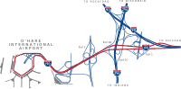 Intersection of Interstates 190, 294, and 90
 Intersection of Interstates 88, 294, and 290


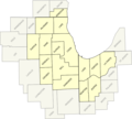 Chicagoland CSA Map