From Wikipedia, the free encyclopedia
Side by side comparison| {{
Template:Infobox mountain range}} | {{
User:Hike395/MtnComboBox}} |
|---|
| Appalachian Mountains |
|---|
|
 | |
| Peak | Mount Mitchell |
|---|
|
Elevation | 6,684 ft (2,037 m) |
|---|
|
| | Countries | United States and Canada |
|---|
| Regions |
Newfoundland
[1]
[2],
Saint Pierre and Miquelon,
Quebec,
Nova Scotia,
New Brunswick,
Maine,
New Hampshire,
Vermont,
Massachusetts,
Connecticut,
New York,
Pennsylvania,
Maryland,
Virginia,
West Virginia,
Ohio,
Kentucky,
Tennessee,
New Jersey,
North Carolina,
South Carolina,
Georgia and
Alabama |
|---|
|
|
Orogeny |
Taconic |
|---|
|
Age of rock |
Ordovician |
|---|
|
|
Side by side comparison| {{
Template:Infobox mountain range}} | {{
User:Hike395/MtnComboBox}} |
|---|
| Andes |
|---|
 | |
| Peak |
Aconcagua,
Las Heras Department,
Mendoza,
Argentina |
|---|
|
Elevation | 6,962 m (22,841 ft) |
|---|
|
| Length | 7,000 km (4,300 mi) |
|---|
| Width | 500 km (310 mi) |
|---|
|
| Native name |
Quechua:
Anti(s/kuna) Error {{native name checker}}: parameter value is malformed (
help) |
|---|
|
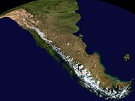 Composite satellite image of the southern Andes
| | Countries | Argentina, Bolivia, Chile, Colombia, Ecuador, Peru and Venezuela |
|---|
| Settlements |
Bogotá,
Santiago,
Medellín,
La Paz,
Cali,
Quito,
Pasto,
Mérida,
Arequipa,
Mendoza,
Cuenca,
Cochabamba,
Pereira,
Ibagué,
Salta,
Manizales,
Cúcuta,
Cusco and
Bucaramanga |
|---|
|
|
Side by side comparison| {{
Template:Infobox mountain range}} | {{
User:Hike395/MtnComboBox}} |
|---|
| Catskill Mountains |
|---|

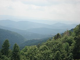
Slide Mountain and the peaks around it as seen from Twin Mountain in the northern Catskills. | |
| Peak |
Slide Mountain, S of
Shandaken |
|---|
|
Elevation | 4,154 ft (1,266 m) |
|---|
|
| Length | 111 mi (179 km) N/S |
|---|
| Width | 102 mi (164 km) E/W |
|---|
| Area | 15,259 sq mi (39,520 km2) |
|---|
|
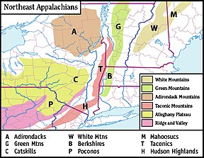 Map of the main regions of the northeast Appalachians, with the Catskills as "C".
| | Country | United States |
|---|
| State |
New York |
|---|
| Region |
Hudson Valley |
|---|
|
Counties |
Ulster,
Greene,
Sullivan,
Delaware and
Schoharie |
|---|
| Communities |
Hunter,
Tannersville,
Monticello and
Liberty |
|---|
| Borders on |
Poconos and
Shawangunk Ridge |
|---|
|
|
Age of rock |
Devonian and
Mississippian |
|---|
|
Type of rock |
Sedimentary |
|---|
|
|
Side by side comparison| {{
Template:Infobox mountain range}} | {{
User:Hike395/MtnComboBox}} |
|---|
| Rocky Mountains |
|---|
|
 | |
| Peak | Mount Elbert, U.S.A. |
|---|
|
Elevation | 14,440 ft (4,400 m) |
|---|
|
| Length | 3,000 mi (4,800 km) |
|---|
|
| | Countries | Canada and United States |
|---|
| Regions | British Columbia, Alberta, Idaho, Montana, Wyoming, Utah, Colorado and New Mexico |
|---|
|
Parent range | North American Cordillera |
|---|
|
|
Age of rock | Precambrian and Cretaceous |
|---|
|
Type of rock |
Igneous,
Sedimentary and
Metamorphic |
|---|
|
|
Range coordinates that are difficult to round
Range coordinates specified only by degrees
Side by side comparison| {{
Template:Infobox mountain range}} | {{
User:Hike395/MtnComboBox}} |
|---|
| Imaginary range |
|---|
Lua error in Module:Location_map at line 425: No value was provided for longitude.
| |
| Country | United States |
|---|
| State | Nevada |
|---|
|
| Imaginary range |
|---|
Lua error in Module:Location_map at line 425: No value was provided for longitude.
| |
|
| Country | United States |
|---|
| State | Nevada |
|---|
|


