For reviewers: I see two possible problems with this draft:
- (1) It has become very long (~9100 words of readable prose); I am therefore considering whether it would be better to split it (this is noted below).
- (2) The last section is a history of regional development since 1949. Aspects such as Bedouin educational institutions, etc., are therefore not mentioned. This has resulted in expropriations of Bedouins being given considerable attention. Alaexis thinks this might be an NPOV issue, and he might be right.
Note that the page's title is outdated; see the Talk page.
DaWalda (
talk) 12:53, 25 June 2024 (UTC)
The Negev is a region in southern Palestine with a complex history, typically part of larger political or cultural entities along with neighboring areas. Notably, only around 1906 or 1947, the Negev was politically separated from the Sinai Peninsula to the west. Despite being predominantly a semi-desert or desert, it has historically almost continually been used as farmland, pastureland, and an economically significant transit area.
The international community widely recognizes the Bedouins as the indigenous people of the Negev, having inhabited the region for about 1,600 years, and for much of that time, almost exclusively. Between 1948 and 1951, during the events of the 1948 Palestinian exodus, many Bedouin inhabitants were resettled by Israelis. Consequently, the later chapters of the Negev's history are marked by ideological debates and are a hotly contested field, with several conflicting narratives. Discussion of these narratives, where necessary, largely takes place in notes.

For historical purposes, the Negev can roughly be divided into four subregions: [1]
- The biblical Negev (yellow), referring to the small, semi-arid northeastern Arad- Beersheba Valley. Only this area is referred to as the "Negev" in the Bible, as according to biblical historiography, the holdings of the Judeans in the Negev were confined to this region. [1]
- The northern Negev (green). In biblical times, it was inhabited by the Philistines and from the 6th century B.C. by Idumeans and the so-called "Post-Philistines," whose ethnic identity remains a matter of debate. This region is also predominantly semi-desert, but it was already intensively used for agriculture during biblical times and developed, especially in the post-biblical period, into one of the most important agricultural regions of Palestine. The northern boundary is indistinct [2] and defined differently by various scholars across disciplines. The border shown on the map corresponds to the modern Beersheba District, which is both one of the northernmost and one of the most commonly used boundaries in historical accounts.
- The central Negev (orange) is even drier; in the Bible, this area was therefore called the " Desert of Zin". In the west, it mainly consists of sand dunes; [3] [4] [5] in the east lie the Negev Highlands, which, as recent research suggests, were probably called " Mount Seir" in the Bible, [6] [7] [8] [9] [10] [11] previously thought to be located east of the Jordan River.
- Finally, the southern Negev (red) has no special name in the Bible. It is the driest region of Palestine, with consistently less than 100 mm of rainfall per year. Originally, it was important mainly for its mineral resources, but starting from the time of the Nabateans, it was also used for agriculture.

The Bible contains several traditions about the Beersheba-Arad Valley and the Negev Highlands. They can roughly be clustered into two groups. From the first group, older biblical scholarship inferred that the Negev was inhabited by the ancient Israelites during biblical times. According to the second group, a different people lived here; this group aligns more with the findings of more recent archaeology (see below).
(1) According to the Book of Genesis, already Abraham lived for a while in the central and biblical Negev after being banished from Egypt. [12] Notably, he spent a brief period living in Kadesh [Barnea] [13] and subsequently resided as a guest in Beersheba, which at that time was purportedly part of the kingdom of the Philistine king of Gerar. [14] (2) Accordingly, Numbers 34:1–7 and Joshua 15:1–3 [15] are generally understood to mean that the biblical and central Negev actually belonged to God's Promised Land at least down to Kadesh Barnea at the southwestern fringes of the central Negev (but see below). This area is assigned to the Tribe of Judah [16] together with other more northerly areas; at the same time, the biblical and central Negev is assigned elsewhere to the Tribe of Simeon and lies within the territory of the tribe of Judah. [17] (3) Hence, when the Israelites came from Egypt to Israel, according to Numbers 20:1–21:3, [18] only Aaron is not allowed to enter this land because he has sinned — the rest of the Israelites, however, can conquer the area.

(4) Conversely, according to Deuteronomy 1–2, [19] the area is revoked from the Israelites by God because everyone has sinned and God has also destined the land for the Edomites. [20] (5) The background for this is found in Genesis 32:3; 33:12–16, [21] where it is not Jacob, the ancestor of the Israelites, who lives there, but his brother Esau, the ancestor of the Edomites. These two grandsons of Abraham divide the promised land between them in Genesis 36:6–8 [22] so that this "Edomite land" will continue to be inhabited by Edomites. (6) According to the Books of Kings, the Edomites also live here. They are sometimes ruled by Israelite kings, as the Negev was purportedly part of the kingdom of the legendary king Solomon (in its entirety, all the way to the Red Sea), [23] and from the 9th century, with varied extension to the south, part of the Kingdom of Judah. [24] But the Edomites fight against them multiple times and regain their freedom. [25] [26] (7) The most common expression used in the Bible to refer to Israel as a whole is " from Dan to Beersheba." Once again, this excludes at least the central and southern Negev regions from "Israel". (8) Accordingly, it is not at all certain whether the border descriptions in Numbers 34 and Joshua 15 really include the Negev as part of the promised land, as Numbers 34 also presupposes an area of Edom west of the Jordan (which, according to Numbers 20:14-16, [27] begins at Kadesh as one of its southernmost locations). For that reason, it has recently occasionally been suggested that "Your southern border shall be from the Wilderness of Zin along the border of Edom" (Numbers 34:3) is to be understood as excluding the territory of the Edomites, and therefore at least the central and southern Negev, from the Promised Land. [28] [29] However, as of yet, this is still a minority opinion.

According to Egyptian written records, during the Bronze Age (up to the 13th century BCE) and the early Iron Age, it was the Shasu nomads who lived in the Negev and the Sinai Peninsula under Egyptian rule. [30] [6] [31] [32] Since these are referred to, among others, as the "tribes of the Shasu of Edom," is assumed that from this ethnic group, the Edomites emerged later, and even later, the Idumeans (see below). The Egyptians operated a copper mine in the Timna Valley, as evidenced by a Hathor temple from that period. [33] After the Egyptians withdrew, another group took over the copper mine. This group also built a fortress-like road station at the Yotvata oasis, which was notably constructed using the casemate building technique, [34] [35] and established another copper mine at Khirbet en-Nahas. [36]
In the Beersheba–Arad Valley, a complex of several casemate buildings also emerged in the 12th century BCE, known as Tel Masos, [37] [38] the region′s first capital (until it was replaced by nearby Tel Malhata as the new capital from the 10th to the 8th century BCE. [39] [40]). From Tel Masos and Yotvata, this architectural style spread throughout the Negev region between the 11th to 8th centuries BCE, with sites like Tel Esdar, Khirbet en-Nahas, Beersheba and Arad adopting similar structures. Additionally, during this time, many more farms, known as "haserim" ("enclosed homesteads"), developed, especially along the streams and brooks up to the vicinity of the Philistine locations Nahal Patish and Tell el-Far'ah (South). Gazit notes that there were 36 Haserim of at least 0.25 hectares in size in the 11th century alone in the region, along with many smaller farms. [41] Moreover, in the same period, about 60 small casemate buildings appeared in the Negev Highlands. [42] Many of these sites also had additional smaller buildings, totaling several hundred. [43] [44] [45] [46] These settlements were likely involved in operating the copper mines, which is supported by the presence of copper slags from the Arabah in Negevite pottery. [47] [48] [49] [50] [51] [52] [53]
These archaeological finds are primarily interpreted in two different ways. Initially, biblical archaeologists, drawing on the biblical passage 2 Samuel 8:14 [54] — which states that King David built garrisons "throughout all Edom" — interpreted the casemate buildings in the highlands as these garrisons, [55] which is why they are still referred to as "fortresses" today. [52] This interpretation was gradually abandoned in the early 1990s: [56] Archaeologists, noting that Yotvata, Tel Masos, and the copper mines were built and operated more than 100 years before David's time, emphasizing that the buildings in the Negev were clearly no "fortresses," and showcasing distinct architectural styles and ceramics different from those in the Judean settlement area, proposed alternative theories. They suggested that either the ancestors of the Edomites built the Negev localities and operated the copper mines, governed by the "Tel Masos chiefdom", [57] [58] [59] [60] [61] or that alongside these nomadic people, a third, unknown sedentary people also lived there, with one of these two groups controlling the copper mines. [62] [63] [64] [65] However, in 2023, Tali Erickson-Gini, responding to the 7 October attacks, once again advocated the older "Israel hypothesis," claiming that this interpretation had been consciously "swept under the rug" by archaeologists. [66] As of 2024, it remains to be seen whether this interpretation will resurface.

| External images | |
|---|---|
The sheer number of Early Iron Age buildings in the Negev Highlands (surveys have registered nearly 450 in total [70]) is surprising given the area's low rainfall (typically less than 200 mm/year [71]). However, the Negevites seem to have developed innovative agricultural techniques to cope with these conditions:
- They built their buildings near the small wadis of the Negev Highlands, where they carved cisterns into the rock to capture and store winter rainwater. [72]
- They also constructed terraced fields along these wadis, designed to channel flowing water from the wadis and running water from the wadi slopes to plants and slow drainage, thus maximizing moisture retention and minimizing soil erosion. [73]
Michael Evenari demonstrated at his experimental Avdat farm that this farming method could successfully grow even grapes with less than 100 mm/year of rainfall. [74]
However, interpretations differ regarding the timing of terrace construction. It is clear that the majority of the millions [75] of wadi terraces still found in the Negev today originated in the Byzantine and Early Islamic periods [76] [77] [78] (see below). But excavated blades, silos and threshing floors from the Iron Age [79] [80] combined with new Radiocarbon [81] and OSL datings [82] [83] suggest that some terraces were built as early as the Iron Age or even earlier. [84] [85] [86] [87]
Conversely, research teams led by Israel Finkelstein investigated ancient dung heaps in the Negev mountains and at the Timna mines and discovered that in the central Negev, small livestock primarily grazed on wild-growing winter and spring plants, [88] [89] [90] while in the Timna area, they were mainly fed hay and grape pomace. [91] [90] Accordingly, they suggest that the practice of crop cultivation in the Negev mountains during the rainy season might have started later. If this is true, the Iron Age Negevites seem to have lived in the Negev mountains during the rainy season, but they only practiced livestock farming there. During the summer time, they moved south to mine copper and imported grain and grape pomace from the Philistines and Judeans in the north. If one agrees with the early dating of the agricultural terraces instead, it appears that the Negevites´ society was structured such that they lived in the Negev mountains during the rainy season, engaging in crop and vine cultivation to stockpile supplies; during the summer, they moved down to the copper mines, mined copper, and fed their animals with the stored hay and grape pomace.
The political situation of the Negevites and their neighboring peoples as well as territorial fluctuations at this time largely depended on the surrounding political superpowers:
- With Hazael's conquest of the region of Palestine in the 9th century, the Judeans in the north strengthened [92] and expanded into the Beersheba-Arad Valley, as evidenced by the ceramics found in Arad and Aroer [93] and ostraca found in Arad. [94]
- The subsequent conquest of Palestine by the Assyrians in the 8th century meant a political and economic upswing for the Negevites (like the Philistines and in contrast to the Judeans). Following this, they expanded further east in the Beersheba-Arad Valley, beyond the borders shown on the map above, to places such as Horvat Qitmit, Horvat Uza, Horvat Radum, Mizpe Zohar, and the Gorer Tower. [95] [96] [97] [98]
- However, it was the conquest of Palestine by the Babylonians in the 6th century BCE that had the most significant impact on regional history. The Judean region north of the Negevites was almost completely destroyed, after which the Negevites advanced north into the more fertile Central Palestine. It is likely this invasion that the pronounced hatred for "Edom" in the later biblical texts originates from. [99] [100] [101] [102] This regional situation remained for the next few centuries: According to Diodorus Siculus and Josephus, even in the 1st century BCE and CE, the border between Judea and the Negevites (" Idumaea") was at the same level, namely "between Beth-zur and Hebron" or "near Gaza." [103] [104]
The economic background of this relocation appears to have been that deforestation had made further copper mining impossible: From the 12th to the 9th century BCE, copper mining was gradually intensified to such an extent that by the 9th century, a total of 460 tons per year were being extracted solely at Khirbet en-Nahas. [105] This, however, led to an overexploitation of natural resources, which eventually brought copper production to a complete halt, as indicated by the analysis of charcoal remains. [106] [107] [108]
Following the decline of copper mining, the Negevites appear to have increasingly focused on trade to the east. Camels seem to have been regularly used for trade starting from this period, as excavated camel and dromedary bones from the late 10th and early 9th centuries BCE suggest. [109] [110] It was also only from this time on that they expanded to the east of the Jordan river and founded Bozra and subsequently other towns along the King's Highway, which until recently were considered the "core territory" of Edom. [111] [112] [113] [114] [115] [116] The pottery found in these areas suggests that the same ethnic groups lived here as in the central Negev and (temporarily alongside Judeans [117] [118] [119] [120] [121]) in the Beersheba-Arad Valley. Thus, when the Edomites relocated to Central Palestine, they left the Negev; subsequent survey results show that only 11 sites can be identified in the highlands from the following period [70] (see below).

Soon after, also the Idumeans living in ancient Edom east of the Jordan river were displaced by invading Arabian Qedarites and moved to join their kin in southern Judah. Subsequently, sometimes between the late 4th and early 2th century BC, these Qedarites were themselves pushed northwestward by the invading Nabateans. [122] [123] As a result, the Idumeans and Qedarites intermingled in southern Judah, [124] while the Nabateans settled in the former territories of Edom east of the river Jordan, the Negev, and Sinai, [125] [126] [127] [128] taking control of these areas and the ancient trade routes. [129] They established the so-called "desert towns" located along the Negev incense route at Avdat, Mampsis, Rehovot, Shivta, Nessana, and especially Elusa, which was to become the new capital and the only polis of the Negev. [130] [131]
Previously, it was believed that the early Nabateans were responsible for the terraced fields in the Negev Highlands, [132] but archaeological evidence does not support this claim. [133] [134] Instead, the Nabateans are rightly famous for two other innovations in the arid desert landscape. First, they developed characteristic arched cisterns. More importantly, second, they constructed long water channels [135] from perennial springs to their cities and villages (as in En Erga, En Ziq, and Qasr Ruheibeh in the central Negev, and En Rahel and Moyat Awad in the Arabah), which functioned in their early time mainly not as agricultural farms but as caravan stops and trade stations. [136]
Josephus reports that the Maccabees conquered the Idumean border towns of Maresha and Adoraim and presented the Idumaeans with a choice: either be circumcised and adopt Jewish customs or leave the area. [137] [138] Since the Idumaeans were already practicing circumcision and several other customs that would gradually come to be seen as "Jewish" after the time of the Maccabees even before the Judeans, [139] [140] it is sometimes assumed that this report is more etiological than historical, intended to explain why the Idumaeans and Judeans had similar customs. [141] [142] However, unlike a corresponding report about the forced conversion of the Itureans, Josephus might be telling the truth in this case: Archaeology shows that during the Maccabean era, almost the entire region was depopulated, mostly without signs of conflict. [143] [144] Following the Roman replacement of the Maccabees as rulers of Palestine it was again repopulated between the 1st century BC and the 1st century AD up to Hebron and Mamre by people that, however, were not judaized, but either continued to adhere to the Edomite belief in Qos or practiced a syncretistic religion with strong hellenistic-pagan and hellenized Edomite influences at least until the mid-fifth century. [145] [146] [147] [148]
According to the Books of the Maccabees and Josephus, the Maccabees did not advance into the central and southern Negev. Hence, archaeological excavations in these areas reveal that the Nabataean religion was practiced there without interruption until the beginning of the Islamic period in the 7th century. [149] Nabatean political control of the Negev only ended when the Roman empire annexed their lands in 106 CE. [130]
During the 4th century, Byzantine rule brought Christianity to the region. This, coupled with a stable political climate, [150] led to a substantial population growth throughout the whole region. [130] Immigrating Christians most frequently settled in the area of today's West Bank down to the Beersheba Valley, which had been most thoroughly ethnically cleansed of Judeans by the Romans. In the Beersheba Valley alone, the number of settlements surged from 47 in the Roman period (up to the 4th century) to 321 during the Byzantine era (4th - early 7th centuries); Beersheba expanded to an area of 90–140 ha, [151] making it even larger than nearby Gaza and Anthedon, each covering about 90 ha. [152]

Iron Age: Era of the copper miners.
Persian Period: Copper miners relocate to Judaea.
Hellenistic/Roman: Nabataeans migrate to the Negev Highlands.
Byzantine/Early Islamic: Christian settlement wave and Arab expansion.
One of the three additional clusters of Christian settlements were the Nabatean desert towns. [154] Most of these evolved into large agricultural villages with many smaller farms and villages around them. [155] Ultimately, the whole central Negev, extending down roughly to the Ramon Crater, was dotted with hundreds of small agricultural villages and farms. These were likely operated by Nabataeans assimilated to the Byzantine Empire, [156] [157] after Nabatean trade had declined starting from late Roman times. [158] On the character of Byzantine (and early Islamic) agriculture in the Negev, see below.
From 602 to 628, the Byzantine military was severely depleted during the Byzantine-Sassanian War and regained control over Palestine only with great difficulty. After that, despite forming alliances with several Bedouin tribes, such as the Banu Amilah, the Banu Ghassan, the Banu Judham, and the Banu Lakhm, who were migrating from the Arabian Peninsula to the southern Negev during this period, [159] the Arab forces encountered little resistance in their Islamic expansion into Palestine beginning in AD 634. By around AD 636, with the decisive Battle of the Yarmuk, the war was largely decided.
As mostly in the rest of the region of Palestine, the Islamic expansion left no archaeological trace in the Negev: [160] [161]
[...N]ot even one of the Negev towns was affected by the Islamic conquest. No hint of a violent invasion or destruction, or even a slight change in the material culture is found in the large-scale excavations of the sites. The archaeological findings point to an uninterrupted pattern of settlement which continued from the Byzantine period into the later stages of the early Islamic period.
— Gideon Avni, 2008 [162]
| External image | |
|---|---|
There are also no clear signs of religious wars and forced conversions. In Nessana, it even appears that the same building was used simultaneously as both a church and a mosque. Similarly, in Nahal Oded (on the southwestern slope of the Ramon Crater), the same building seems to have served as a pagan cult place and a mosque at the same time. [164] Related to this phenomenon is the fact that the early Palestinian Muslims even integrated the Christian festivals of Easter, Pentecost, Christmas, and Saint Barbara into the Muslim calendar. [165] Therefore, on the eve of the Crusades, Palestine was still predominantly Christian. [166] Hence, Ibn al-Arabi, who visited Palestine at the end of the 11th century, could still write: "The country is theirs [the Christians'] because it is they who work its soil, nurture its monasteries and maintain its churches." [167]
The Arabic invasion, however, accelerated a trend toward deurbanization and ruralization, especially in the Negev, which had already started in Byzantine times, to which a number of factors contributed:
- By the end of the Byzantine period, Christianity had become widespread in Palestine; however, within Christianity, the characteristic aspects of Roman-Byzantine urban culture were viewed as promoting unchristian frivolity. Consequently, urban institutions such as Roman baths and theaters began to be dismantled or destroyed from this time onward, reducing the appeal and hence the pull factors of cities. [168] [169] [170]
- Many monks, whose monasteries often served as the Christian centers of smaller towns (as in Avdat and Nessana [171]) left Palestine after the Arab invasion, diminishing another pull factor of these towns. [172]
- A drought during the Late Antique Little Ice Age in the early sixth century, the Plague of Justinian that broke out in the densely populated cities of southern Palestine in the mid-sixth century, and a severe earthquake in the Negev toward the start of the early Islamic period drove urban populations to the countryside, where they now had to fend for themselves. [173] [174] [175]
- In Southern Palestine, a new economic sector emerged due to the strong international demand for " Gaza wine," which was primarily produced in Yavneh, Ashkelon, and Gaza. [176] To capitalize on this, some inhabitants of the Negev towns took up viticulture in the countryside. [177] [178] [179] [180] Curiously, viticulture and trade with Gaza wine continued unabated in the first Islamic century [181] and even the Arabs themselves praised the quality of Palestinian wine. [182] After the wine trade collapsed, it seems that the vineyards were instead continued to be used for olive cultivation. [183]
- The Arab conquest and the Muslim imposition of two new taxes called Jizya and Kharaj on non-Muslims and non-Bedouins led to the cessation of the flow of Christian immigrants. The absence of Christian pilgrims also dried up financial flows, [184] prompting even more Palestinians to turn back to subsistence farming.
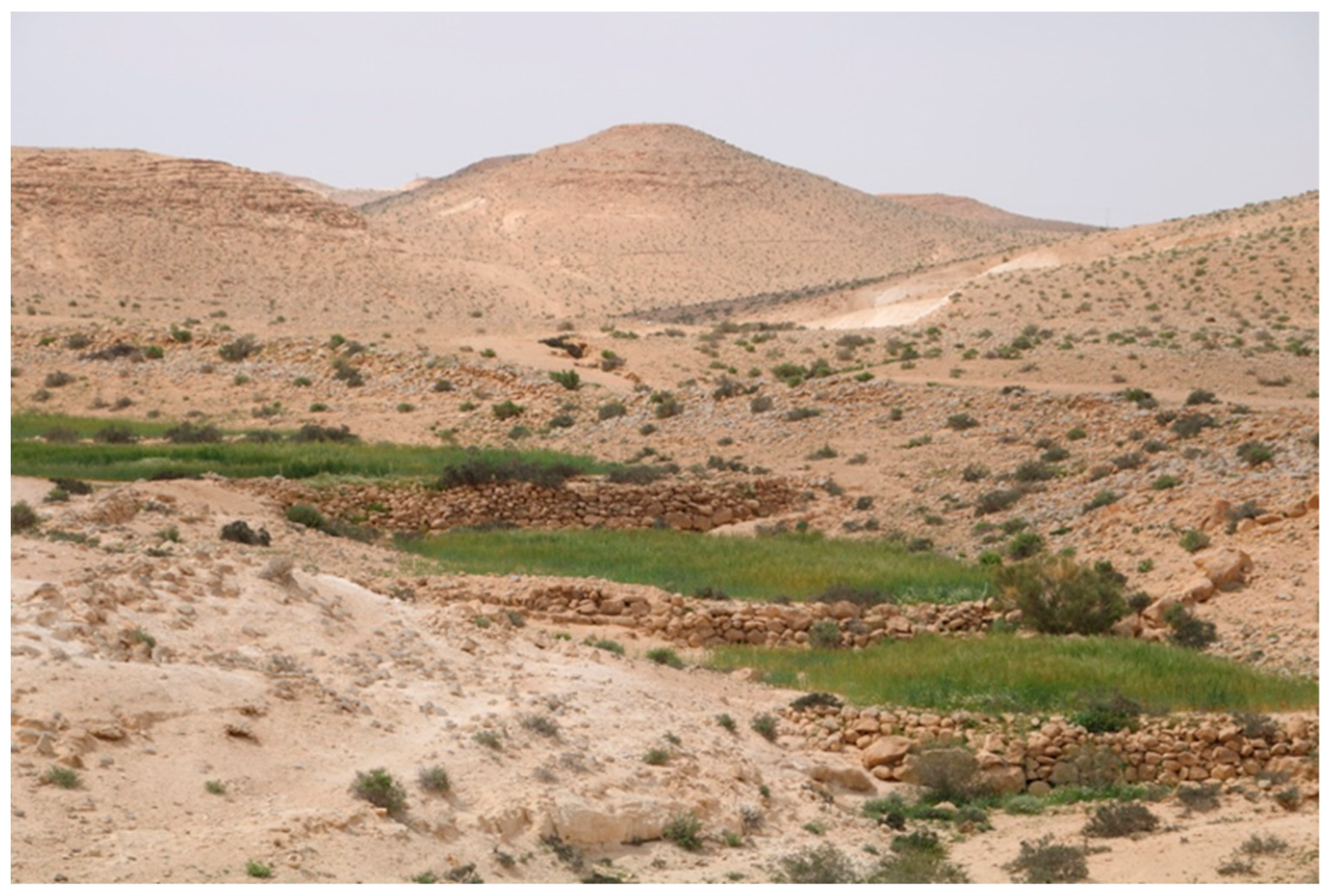
Already in the Byzantine period, 90% of the settlements in the Negev were agricultural farms and villages. Following the decline of the towns during the early Islamic period, the total number of settlements gradually decreased, [nb 1] yet the proportion of agricultural villages among these settlements further increased. According to Rosen, this shift of life from cities to rural areas is the reason why most Byzantine churches are found in the desert towns, whereas most early mosques are found in rural areas. [189] Also, further to the south, around the Ramon Crater at the southern fringes of the Negev highlands, the Negev Bedouin replicated the northern terrace architecture. [190] Haiman estimates that during the early Islamic period, there would have been about 300 individual farming villages, each with 80–100 residents, cultivating a total of approximately 6,500 hectares of agricultural land (nearly 3% of the total area of the Negev Highlands). [191] Newer surveys suggest that they might have cultivated even up to 30,000 – 50,000 hectares, which would correspond to nearly 14 – 23% of the area. [192] [193]
Meanwhile, the desert towns gradually died a quiet death: Elusa collapsed already towards the end of the Byzantine period, likely due to the Justinianic Plague and the Late Antique Little Ice Age. [194] Mampsis was abandoned either by the 7th or 8th century, Rehovot by the 8th century. The abandonment of Avdat, seemingly due to an earthquake, [195] [196] is now also dated to the 8th century. [197] The archaeologically poorly preserved Beersheba and its surroundings, including the revitalized towns Tel Masos, Tel Malhata and Tel Ira may also have been abandoned by the 8th or 9th century. However, Shivta, Nessana, and the large Khirbet Futais (in the area of the former Philistine Nahal Patish) continued to exist at least until the 10th century. In Ayla, where the new inhabitants of the region resumed mining copper and started to mine gold, there can even be observed further growth; the towns were only abandoned in the 11th century. [198] [199] [200] [201]
From the 12th century onwards, as the Crusaders and then the Mamluks ravaged central and northern Palestine, most of the villagers and townspeople of the Negev had already migrated to these regions or to Europe. This, the war waged by the Crusaders against Southern Palestine as well, and the (not certain but likely) fact that the Mamluks prohibited permanent settlements in the Negev, led to the transformation of the Negev into a region inhabited solely by semi-nomadic and predominantly Muslim Bedouins. [202]
If agriculture was already practiced on terraces during the Iron Age, this system was certainly further developed from the Byzantine period onwards:
- Starting with the Byzantine period the Negevites stacked stone heaps, called Tuleilat el-Anab ("grape mounds"), [203] to further facilitate the flow of rainwater into the wadis [204] and probably also to reduce evaporation in the soil beneath these heaps for growing grape vines. [nb 2]
- They also constructed artificial dovecotes alongside the terraces, so that the pigeons could fertilize the agriculturally used soil with their droppings. [208] [209] [210]
- Finally, the most sophisticated irrigation system dates back to the early Islamic period: The inhabitants of the arid area around Yotvata in the southern Negev constructed tunnel systems known as " qanat," spanning several kilometers. These tunnels served as irrigation channels, directly connecting groundwater reservoirs to agricultural fields covering several hundred hectares. [211] [212] [213] Uzi Avner writes that according to radiocarbon data, after the destruction of Ayla in the 11th century, "only small-scale cultivation was continued by Bedouins;" [214] however, he does not specify how this "only small-scale" cultivation is identified. New research suggests instead that agriculture near Eilat was later expanded (see below).
split here? (1) Ancient History of the Negev, (2) History of the Negev Bedouins
Outsource "The cultural region of the Negev Bedouin" as "Timeline: Territorial History of the Negev."?
After the Christians gradually had migrated back to Europe or central Palestine until the 11th century, Bedouins constituted almost the entire population of the Negev until the 20th century. After the 6th century, only the political boundaries changed, not the cultural ones:
The Negev, Sinai, southwestern Jordan, and northwestern Hejaz were part of a unified territory for most of the Bedouin period. This was also the case during the times of the Shasu, Edomites, and Nabataeans (see above), as well as during the Roman period, when these four regions were initially combined into the province of Arabia Petraea and later, excluding the Hejaz, into the province of Palaestina Salutaris. [215]
- During the Early Islamic Period, Arabs made a biblical and quranic distinction between the "Fahs al Tih" (the "Area of the Wanderings [of the Israelites in Moses' time]") which roughly extended from Rafah down to Jabal Musa as the assumed Mount Sinai, and the adjacent western area "Al Jifâr," bordered to the west by a line from the Lake of Tinnis to the Gulf of Suez. [216] However, politically, both areas were usually considered part of "Filastin". [217] In mental geography, this part of Filastin was seen by the sedentary population as a transit area: for Christians, a transit area with a north-south axis from Palestine along the Arabah valley on the Negev's eastern fringes to Saint Catherine's Monastery on Mount Sinai; [218] for early Muslims, a transit area with a west-east axis from Suez ("Qulzum") via Nakhl (and smaller waystations) to Aqaba and from there further to Medina and Mecca, [219] and another west-east axis along the Via Maris on the Mediterranean coast, facilitating trade between Egypt and Palestine.
- Not much is known about the territorial affiliation of the Negev during the time of the Crusaders. It is certain that west of the Jordan river, the line from Deir al-Balah ("Darom") to Al-Karmil was the southern boundary of the area settled by Europeans. [220] Beyond this boundary lay "La Grande Berrie," the "Great Desert." However, whether this area was entirely outside the European domain [221] or should be considered a vast border region [222] remains unclear. It is certain, at least, that the Crusader castles east of the Jordan River, which stretched further south along the Christian pilgrimage route and were known as Oultrejordain, served as a wedge between the western and eastern Muslim settlement areas, [223] from where, among other things, the west-east Hajj route was obstructed by raiding the Muslim pilgrims. [224] Thus, during the 12th century, at least the Sinai and Negev on one side, and Jordan and Hejaz on the other, were somewhat separated. Accordingly, towards the end of the first Christian Crusader period (1171), Theoderich of Würzburg distinguishes between "Arabia" to the east of the Jordan river and the desert "between Arabia and Egypt" to the west. [225]
- During the Mamluk period, Al-Dimashqi reports that, after the area around Oultrejordain had been reconquered, the entire region from the Gulf of Suez (" Qulzum") in the west of Sinai to the south of Jordan, including Ma'an, was again consolidated as the "kingdom of Karak" (after its capital Al-Karak). [226] The Egyptian Hajj route through the Sinai to Aqaba was fortified by expanding the waystations and later upgrading them to small fortresses. [227] Following the time of Al-Dimashqi, textual sources fall silent for two centuries. However, since the Ottomans, as usual, structured the area politically in a similar way to the Mamluks, this division likely persisted:

- During the Ottoman period, the southern territorial boundaries of Palestine were often unclear, even to the Ottomans themselves. [228] Most of the time, the Negev, the Sinai Peninsula to the west and parts of southwestern Jordan and the Hejaz to the east was again regarded as one unified region; this time under the name "Province of Hijjaz". [229] However, parts of this area were at times instead included within the frequently shifting [230] boundaries of the Gaza District. In the next section, a snapshot from 1835 is displayed, [231] just before the territorial reorganizations of 1840, 1871-1874, and 1906. [232] [233]
- Only during the border dispute from 1892 to 1906 towards the end of the Ottoman period (see below) was the Negev gradually separated as a distinct area from the rest of this cultural region.

The territories of the Tarabin and the Aheiwat extended far into the Sinai Peninsula; however, the boundaries of their areas in this region are less well-known.
The history of the Arabs of Beersheba remains poorly researched. It is certain that the names of many tribes residing in the Negev area in the early 20th century are not attested in earlier times. [235] This doesn't tell us much; of the dozens of Bedouin tribes that lived in the Negev during this time or had once lived there, only a very few are documented in texts. More importantly, it is often mentioned in Bedouin oral history that individual tribes have only been living in the Negev for a few centuries.
However, this does not necessarily mean that these tribes were newcomers. All major Bedouin tribes in Palestine are actually tribal confederations. For the regional history of a tribal confederation, it is more accurate to consider the history of its sub-tribes. For instance, the Bilī [235] [236] and the Jerawin [237] arrived in the Negev already before the Islamic era and are now sub-tribes of the Tarabin and the Tiyaha, which indeed arrived only in the 18th century. Similarly, the Jarm lived in the Negev already during the Crusader period, were the ruling tribe during the Mamluk period, and eventually split and joined the same tribes. [237] The Wuhajdat, the ruling tribe during the early Ottoman period, collapsed and joined the Tarabin, the Tiyaha, and the Jabarat. [238] Other sub-tribes of the Bedouins trace their origins back to former Palestinian villagers who became semi-nomadic only late and joined the major tribal confederations. The Amarīn, for example, now a sub-tribe of the Jabarat, were originally inhabitants of a village near Ramle. [239] Thus, over the centuries, many migrations and reconfigurations among the Bedouin tribes can be traced; however, the example of the Bilī, the Jerawin, and the Amarīn shows that, due to these reconfigurations, even tribes that migrated more recently can have roots in the Negev dating back many centuries.
Despite frequent migrations and border wars, Bedouin tribes had shifting but well-defined territories. Land ownership was governed by a set of Bedouin laws, which were enforced both at the community and individual levels by the tribes collectively: [240] [241]
- Invading tribes from outside were to be allowed to stay in the tribal territory. If they entered without such permission, they were expelled by a coalition of the native tribes.
- Individuals had land rights only within their tribal territory. Land was acquired by developing unused farmland, through the removal of stones ("stoning"). A field cleared of stones was considered private property. Usually, half of an owner's lands lay fallow each year as part of a crop rotation system. [242] Additionally, an owner could decide not to cultivate fields for several years if there were not enough pasture plants for his animals in the surrounding area due to a drought. If another individual successfully cultivated a field in the owner's absence over several years, the owner was usually informed by neighboring field owners and a property dispute arose. This was adjudicated by a council of judges called "ahl ad-diyār" ("people of the lands"), typically chosen from tribes other than the one to which both parties belonged.
.jpg)
Regarding the Bedouin land use of the Negev after 1100 AD, there are two differing positions in the research. According to the first, even the agricultural terraces were abandoned concurrently with the decline of Negev towns and villages around the 10th / 11th century. [243] [244] [245] [nb 4] Proponents of this position generally also assume that Bedouins only re-learned agriculture from more sedentary cultures in the late 19th or even the 20th century, and only began practicing it themselves due to the sedentarization policies initiated by the Ottoman Land Code of 1858 (see below), and later continued by British and even Israeli policies. [257] [258] [259] [260] There are indeed travel descriptions from the interim period that suggest this. However, since they all evidently reproduce the same set of general world knowledge, it is uncertain how reliable they are. [250] [251] [252]
Evidence from newer archaeological excavations and historiographical studies indicates instead that both assumptions are at least somewhat exaggerated. Instead, corresponding to Bedouin oral history (see above), archaeology suggests that "nomadic [...] tribes, living in the Negev Highlands between the 10th and 18th centuries cultivated some of the best-preserved agricultural plots and primarily grew annual crops, such as cereals, and occasionally also managed small plots of fruit trees," [261] and did not abandon either the northern and biblical Negev or the southern Negev. [nb 5]
For the 19th century, there is another set of evidence from textual documents directly concerning Bedouin culture, suggesting that extensive Bedouin agriculture in the Negev certainly predates the Ottoman and British land policies. Notably, there is a wealth of travel literature from the 19th century that frequently discusses the Negev region, as well as the first ethnological studies. Again, many travel reports report having encountered a dead desert. [269] However, Avi Oppenheim [270] and the authors of "Emptied Lands" [271] have highlighted that many travel accounts also report the opposite. From these, it is particularly clear that Bedouins cultivated wheat throughout the northern Negev. Agriculture in the biblical Negev and the highlands of the central Negev is also well-documented. [nb 6]
This agriculture was not associated with a sedentarization of bedouins. Starting with the Shasu nomads and their copper mines and Negev fortresses, Palestinian nomads were always semi-nomadic, as the land did not allow "pure" nomadism. [278] [279] Most of them were still semi-nomadic in 1948, [nb 7] although towards the end of the mandate period there was indeed an increasing tendency to build individual permanent houses or storage facilities within larger recurring tent dwelling places. [285]
| External image | |
|---|---|
At the same time, it is certain that Europeans indirectly contributed to those semi-nomadic Bedouins intensifying their agricultural activities from the late 19th century onwards. Two of the Bedouins' most important economic activities were the transportation of goods (especially grain) [287] and the "protection" of caravans, [288] including the Hajj pilgrims on their way through the desert (sc. the collection of protection money to refrain from attacking them while passing through their tribal territories: → Amir al-hajj). In the 1830s, however, Egypt's Muhammad Ali and Ibrahim Pasha briefly ruled over Palestine and neighboring regions, modernizing and intensifying agriculture in the north. [289] This attracted more Europeans with their newly developed steam boats to Palestine, [290] from where they initially imported primarily olive oil, soap, [291] and cotton. [292] These steam boats over the time made Bedouin transportation irrelevant. [293]
._Beersheba._Bedouin_grain_deposits._Barley_piles_covered_with_straw_and_earth_LOC_matpc.15532.jpg)
However, steamship trade enabled the British to also import barley from Palestine. Thus, from the 1850s, even before the enactment of the Ottoman Land Laws, Gaza developed into a hub for trading "Gaza barley," alternatively called "badawi abyad" ("Bedouin White"). During several years of the Ottoman period, Gaza barley was Palestine's economically most important export, with tens of thousands of tons exported annually. [294] [295] [296] Additionally, textiles were exported from Gaza, produced in at least 100 workshops using wool supplied by the Bedouins, and soap, for which the Bedouins provided potash. [297] [298]
From just before the start of the British Mandate (1923) until the end of the Mandate period (1947), there were several surveys of the Negev that showed how much Bedouin agriculture had intensified over time. According to most estimates, the agricultural area gradually increased during the British Mandate period from about 300,000 hectares to 400,000 hectares [299] [300] [301] [302] [nb 8] (a comparable, but significantly larger, growth trend is also evident in the adjacent southern West Bank [306]). This constituted nearly 36% of the agricultural land in the region of Palestine [307] and encompassed almost the entire northern half of the Negev. [308] As parts of this area weren't suitable for agriculture (mainly due to the sand dunes in the western central Negev [3]), this also implies that the Azazima used the Negev Highlands for agriculture during the Mandate period comparably to the Nabateans in the Byzantine era. Correspondingly, in 1941, Jacob Verman and Daniel Zohary had explored the Negev highlands. According to this survey, Bedouins practiced wadi agriculture in practically every region of the Negev highlands except for the Wadi Boker area and the Nahal Ramon area near the Ramon Crater [309] – partly on reused, [310] partly on enhanced [311] and partly on self-built terraces. [312] In the process, the terraces were further developed:
- When raising reused terraces, small "breaker lines" of stones were sometimes built in front of them to reduce the force with which winter floods hit the main terrace. [313]
- Newly built terraces were constructed with a characteristic slope that faced the water, also mitigating the force of the floods. [314]
Thus, British diplomats declared:
The statement, so often made for propaganda purposes, that nearly half of Palestine (Naqab) is still empty and available for settlement is roughly speaking true as regards its emptiness but altogether false and misleading as regards its availability.
— PRO, FO 371/61868 [315]
split here?
Until the mid-19th century, there was no "Negev" as a clearly defined region. What would later become known as the "Negev" had always been part of a region that included the Sinai, and usually also southwestern Jordan and northwestern Hejaz (see above). This changed only after 1840: [nb 9]

After the Egyptian–Ottoman War from 1839 to 1841, in which the Egyptians were pushed back in Palestine and which was ultimately a proxy war between France, supporting the Egyptians, and England, supporting the Ottomans, [322] [323] [324] it was enforced [325] at the Convention of London in 1840 that Egypt largely withdrew from the Sinai but was granted an area within its "ancient borders" northwest of a line from Rafah to Suez. This territory was then assigned to their Egyptian subjects by the Ottomans with the so-called "Inheritance Firman" of 1841. [326] Later, the starting point of the Firman line from Rafah would mark one of the two points crucial for the creation of the Negev.
The French subsequently built the economically vital Suez Canal by 1869, whose southern end still lay in Ottoman territory. [327] [328] However, after England had made Egypt their colony ("protectorate") in 1882, only the British benefited from this, while it economically harmed the Ottomans [329] and made Ottoman troop movements to Palestine and in the Hejaz dependent on whether the British would allow them to pass. [330]
At this time, the Ottomans did not even effectively control the Negev, [331] [332] and even less the Sinai Peninsula, where the Egyptians continued to administer the waystations along the two west-east routes via Nakhl and Aqaba and via el-Arish, [333] as it was also stipulated in the Inheritance Firman. This Egyptian presence in Aqaba, as the easternmost point of Egyptian control, would soon become the second point defining the Negev border line.
| External image | |
|---|---|
This led to the territorial status of Sinai and the Negev becoming somewhat ambiguous after 1841: The Ottomans initially sometimes produced maps that depicted the Negev as "Egyptian" territory, [335] while the Egyptians produced maps that did not recognize even the area of the Inheritance Firman as part of Egypt. Thus, the Ottomans began efforts to extend their de facto control southwestward. Meanwhile, the British sought to keep the Ottomans away from the Suez Canal and the Gulf of Aqaba, which had the potential to threaten their dominance in the Red Sea through the Suez Canal. This struggle for the Sinai and the Negev is not well-known, but it is actually one of the major chapters of World History, as it almost precipitated the First World War already by 1906. [336] It unfolded roughly in four steps:

Step 1 consisted of two measures that were more symbolic than directly political: When Egypt's ruler, Khedive Tewfik Pasha, died in 1892, the Ottomans had to confirm the rule of his son, Abbas Helmy II. In the renewal of the firman that confirmed Abbas as the ruler of Egypt, however, the passages regarding the Sinai waystations were omitted, [337] and instead, it was only stated by the Ottoman Sultan Abdul Hamid II in a telegram that Egypt should continue to administer the waystations. [338] This did not initially change the status quo. However, by transferring the mention of these waystations from the firman to a telegram, it emphasized that these areas were still to be considered Ottoman, not Egyptian, territory.

The British Consul General in Cairo, Lord Cromer, did not accept this and responded with a telegram of his own, violently misinterpreting [339] the Sultan's telegram as meaning that Egypt should administer the whole Sinai Peninsula, which he defined as "the territory bounded to the east by a line running in a south-easterly direction from a point a short distance to the east of El Arish[, the easternmost waystation on the coast,] [...] to the head of the Gulf of Akaba.'" [340] Thereafter, the British began to produce maps that even excluded the head of the Gulf of Aqaba from Ottoman territory and presented everything southwest of the thus defined border as "Egyptian." In 1892, there was no response from the Ottomans to this telegram; it was officially rejected only in 1906. [341] For this reason, Cromer's telegram is sometimes regarded as a British–Ottoman "agreement," [342] [343] while others see it as merely a "unilateral declaration" not accepted by the Ottomans [344] or a wrong "interpretation" on the side of the British. [345]
It is possible that the early Zionists also played a role in this matter: The first generation of Zionists had been attempting to settle in Palestine since 1882, but Jewish immigration to Palestine and Jewish land purchases in Palestine had already been prohibited by Ottoman law that same year; [346] partly because, since the 1840s, the British had inserted themselves into Palestine by claiming the status of protector of Jews wishing to immigrate there. [347] [348] As a result, they tried to enter Palestine as illegal immigrants or via indirect routes. One such indirect route was the attempt by Paul Friedmann around 1892, with the consent of the British occupation authorities, [349] to establish a Jewish state called "Midian" on the Gulf of Aqaba's east coast, [350] which Cromer was just about to declare as "Egyptian": Cromer himself reports that it was this attempt that brought the Ottoman Sultan to redraft the Firman. [351] [352] However, since this was but a rather desperate colonization attempt and Cromer's report is quite misleading, [353] it is not certain whether this was indeed a major factor.
The second step consisted of a series of Ottoman actions aimed at gaining control over the Negev and Sinai. These began with the so-called " Tanzimat land reforms", [354] [355] which included a package of legislative amendments designed to privatize and commodify land. The goal was to sedentarize the Bedouins in the Ottoman border regions and thereby stabilize these areas. [356] [357] In the second half of the 19th century, the Ottomans still tried to achieve this through coercion.
Since these measures were not successful in the province of Hejaz due to the lack of Ottoman military troops, [358] they shifted their Bedouin policy around the turn of the century, when the border disputes began, aiming "to gain Bedouin support for the government in its endeavors." [359] Thus, in 1892, the Ottomans started to buy the favor of Bedouin sheikhs by bestowing titles upon them. [360] Now, instead of imposing governors upon the Bedouins, [361] they had a say in the appointment of governors and could even dismiss them. [362]

The culmination of this new policy [363] was the creation of the new Beersheba District in 1899, whose boundaries were drawn in such a way that it was almost exclusively a Bedouin district. [364] As a regional center, the city of Beersheba was built at a point where the tribal territories of three major Negev Bedouin tribes converged. Instead of granting Bedouin land to sedentary refugees for settlement, as had been done before, [365] now the Bedouins were given land in this city for free. [366] The more Bedouin-friendly policy went so far as to allow legal matters relevant only within this new Beersheba district to be adjudicated according to Bedouin customary law by a "management council" of tribal chiefs, unlike in northern regions. [367]
Lord Cromer wanted to respond to this by now pushing the boundary he had earlier drawn himself in the north from el-Arish to Rafah; however, the British Foreign Office explicitly rejected this proposal. [368] Nevertheless, around 1902, two measures were undertaken to further shift the northern boundary. First, the two boundary markers at Rafah, which were said to have marked the ancient boundary line between Palestine and Egypt, [369] were either moved [370] or newly established [371] unilaterally by the British and Egyptians in accordance with Lord Cromer's new proposal. The Ottomans would respond only in 1906 (see below); in 1902, however, this British action again had no direct consequences. [372]
Second, some Zionists had already anticipated this boundary-shifting proposal from Cromer and interpreted the creation of the Jerusalem Sanjak in 1887, [373] which reached only down to Rafah at that time, as a cession of Ottoman-Palestinian territories to Egypt. Subsequently, they developed plans to begin the colonization of Palestine in the "Egyptian-Palestine" region between el-Arish and Rafah. [374] This led shortly afterward to Theodor Herzl's attempt from 1902 onwards to negotiate this area from the British for a Jewish state. [375] [376] Since the British were willing to negotiate over all areas "where there were no white people as yet," [377] Lord Cromer was initially indeed willing to cede him territories west of el-Arish, which harmonized well with his own plans to push back the Ottomans. However, soon thereafter, he withdrew the offer again — officially, because Friedmann's attempt near Aqaba had already enraged the Ottomans, [378] [379] and because the Zionist plans to irrigate El-Arish with pumped Nile water were unrealistic; [380] but actually, probably mainly so as not to "'remind' the Ottomans to address the delimitation problem, and to claim that a foreign settlement was not permitted in the province of Hijaz, which included Sinai." [381]
Although these early plans to colonize el-Arish failed, they still had lasting repercussions: later, they prompted the Zionists to claim, at the Paris Peace Conference of 1919, a Palestine whose southwestern border extended from el-Arish to Aqaba, closely matching Lord Cromer's earlier proposed border redefinition.
With this background, the ground was prepared for the struggle for the Negev to almost escalate into an international war. The trigger was the serious Ottoman preparations made in that year to connect the Gulf of Aqaba [382] or even the Gulf of Suez [383] [384] with the Hejaz Railway. This would have given the Ottoman armies, and through the Berlin–Baghdad railway, which had also been seriously considered since 1903, [385] the armies of their newly allied Germans direct access to the Red Sea. Control over this maritime region, which connected England with British India, was crucial for the British Empire; [386] therefore, the British could not accept these efforts by the Ottomans and the Germans. [387] [388]
Thus, Lieutenant Bramly was sent with some 50 Egyptian policemen to the Gulf of Aqaba, which had been administered solely by the Ottomans for some time, to establish several police stations there. [389] [390] A post was provisionally set up in present-day Eilat but had to be dissolved shortly afterward on orders of the Ottoman commander of Aqaba. [391] [392] Attempts at other planned locations — especially the strategically important Taba on the western shore of the gulf, which the British considered to be within Egyptian territory — were abandoned after it was discovered that the Ottomans already had troops stationed there and were amassing more forces, eventually numbering over 2000 men. The policemen then barricaded themselves on Pharaoh's Island, [393] [394] prompting the British to send the warship Diana to the Gulf, outgunning the Ottoman soldiers. Another destroyer, the warship Minerva, was dispatched to Rafah [395] after discovering that the Ottomans had torn down the boundary markers earlier relocated by the British, gathered several hundred troops there as well, and replaced some British telegraph poles with Ottoman ones [396] [397] [398] to indicate that, in their view, the region southwest of Rafah was Ottoman territory.

Attempts to resolve the emerging crisis diplomatically were unsuccessful. The British insisted that the border between Egyptian territory and the Ottoman heartland ran from Rafah to Aqaba — "the invention of a moment [...], it had never been heard of before." [399] The Ottomans, while making two compromise proposals to redefine the borders, [400] which were not accepted by the British, maintained that at least some parts of the Sinai belonged to them instead of the Egyptians. Thereupon, the French and the Russians publicly pledged their support to the British Empire. [401] At the same time, it was feared by the British and claimed by the Ottomans that in the event of war, the Germans would side with the Ottomans, although Germany officially denied this. [402]
When even the support of France and Russia for the British proved ineffective and the Ottomans threatened to put the issue forward for international arbitration, [403] the British quickly issued an ultimatum to the Ottomans in May 1906: either they accept the border from Rafah to Aqaba, or the British would occupy the strategically important Ottoman-Greek islands, including Lemnos and Imbros near the Ottoman capital Constantinople, and block all Ottoman maritime traffic in the Mediterranean. [404]
Hereafter, the Ottomans finally yielded to British pressure and both drew a boundary from Rafah to Aqaba in 1906. This line, however, was legally not an international border, but merely an administrative boundary between two Ottoman territories. [405] This distinction was underscored by a British letter to the Sultan, reaffirming that Egypt was still recognized as an Ottoman province under the sovereignty of the Ottoman Empire. [406]
.jpg)
Thus, the border question continued to linger even after 1906. For instance, in 1907, the British, once more trying to extend their sphere of influence northward with the help of Zionists, encouraged the Anglo-Palestine Jews Club to establish a "colony of British Jews at Gaza." [409] When this attempt failed, the British consular agent in Gaza launched a similar project, aiming to purchase around 5000 hectares of land at the new Egyptian-Palestinian border near Rafah for another Jewish colony, to at least stabilize the border. This attempt also failed, as the Egyptians did not want a Jewish colony on their land either. [410] Simultaneously, the Ottomans began producing maps that depicted a somewhat fictitious administrative geography by including the entire Sinai Peninsula within the Sanjak of Jerusalem. Nevertheless, the issue remained dormant and truly new developments occurred only from 1919 onwards, when England sought the Mandate for Palestine after World War I.
During World War I, to increase their chances of being granted the Mandate for Palestine after the war, England made three secret agreements: The McMahon–Hussein Correspondence, the Sykes–Picot Agreement and Balfour Declaration. Taken together, these meant that, according to the vision of the French and British, the Negev, Jordan, and Hejaz would once again be politically "united", but this time as part of the externally controlled greater Kingdom of Arabia.


However, the British did not regard either these agreements or the recently established border agreement as binding. Thus, once the British were indeed granted the mandate, they adopted the Ottoman view that the newly drawn boundaries had merely been administrative borders between two Ottoman territories, [412] [413] and began to consider various options for alternative border demarcations in the south of Palestine anew.
The Negev question was negotiated primarily on two occasions. The border between Egypt and "non-Egypt" was the subject of negotiations from 1917 to 1919. The provisional retention of the 1906 boundary was a British compromise between a Zionist demand for the territory east of a line from the Gulf of Aqaba to el-Arish, and an Egyptian demand that also included Gaza and Beersheba as the two economic centers of the Bedouins for Egypt. [414] [415] The British themselves would have preferred borders that lay between the British-Egyptian demands and the southernmost British proposal for border demarcation by T. E. Lawrence (see the map above), which would have left most of the Negev as part of Egypt. This compromise border only achieved the status of an official international border around 1979 with the Camp David Accords. [416] Galilee reports that as of 2019, Bedouins still regarded the regions on both sides of the arbitrarily drawn national border as a single region. [417]
In 1922, the Negev was again the subject of negotiations, as the borders between Palestine and the territory of the designated Jordanian King Abdullah had to be drawn. His father, Hussein, King of Hejaz, had been promised the Negev by the British, among other things, in the McMahon-Hussein Correspondence. Here too, this (already promised) maximum demand of the Jordanians was met with a maximum demand of the Zionists, who also wanted the fertile highlands east of the Jordan river for their national Jewish homeland. Again, the Zionists did not have to make significant concessions, as a compromise was decided by the British, according to which the border should run along the middle of the Jordan River. [418] The promised Negev land was not relinquished by King Abdullah himself, but by British representative St John Philby "in Trans-Jordan's name". Philby's ability to concede the region to the Zionist Organization was based on the argument that Abdullah had received permission from his father to negotiate the future of the Sanjak of Ma'an (which had previously been a part of the province of Hejaz). [419] Even if this was true, it would have been a blatant breach of word by the British, as this was certainly not the position of Abdullah, who made a request for the Negev to be added to Transjordan in late 1922. However, this was rejected by the British. [420] Thus, despite not having been historically considered part of the region, the Negev was added to the proposed area of Mandatory Palestine on 10 July 1922. In this case too, the final border was only established as international border in 1994 in the peace treaty between Israel and Jordan. [421]
When England assumed the League of Nations mandate for Palestine, [422] [423] it took on a "dual obligation": (1) to the Palestinians, to guide them towards establishing a self-governing state, [424] [425] and (2) to the Zionists, to "use their best endeavours to facilitate the achievement [...] of the establishment in Palestine of a national home for the Jewish people" (→ Balfour Declaration).
.jpg)
For England, this dual obligation mainly served as a pretext [426] [427] to extend the mandate, which effectively only meant a "change of colonial masters" [428] [429] from the Ottomans to the British, for as long as possible, because the "national home for the Jewish people" still needed to be established. Accordingly, the British promoted massive Jewish immigration to North and Central Palestine during the mandate period and redistributed money from Palestinian farmers to Zionist industries through taxes. [430] [431] [432] This was further exacerbated by the Ottoman exploitation of Palestine for World War I, by eight consecutive poor agricultural years, [433] and by various British land concessions to the Zionists. [434] Hence, by 1930, 29.4% [435] of Palestinian farmers had lost their land to banks, wealthy Arabs, or Zionists, [436] while by 1948, the Zionists had legally acquired just under 8.5% of mandatory Palestine. [437]

In the Negev, however, Zionists were slow to establish a foothold. The desert played a central role in Zionist mythology: neglected by the Palestinians, the entire Promised Land had become a desert and now had to be saved by its rightful inhabitants. [440] [nb 10] However, due to Ottoman [457] [458] and British [459] settlement policies, Zionist colonization of the Negev predominantly began only in the 1940s: Until the end of the 1930s, the southernmost Zionist settlement was Kfar Menahem, established north of the Negev in 1935.

The only exception was the farm Ruhama (1911), built by illegal Russian immigrants [460] [461] on the land of the nearby Bedouin village al-Jammama, where in 1912 the first pumping station in Palestine was constructed. [462] Ruhama, however, was not profitable without external investment: From the beginning, the first generation of settlers did not have enough money to pay the expelled former tenants their compensation [460] and seem to have paid for the appropriated land only in 1913; [463] during World War I, the first owner had to incur massive debts; [464] [465] after the war, the farm was initially scaled back by its second owner for the same reasons and gradually abandoned by its Jewish inhabitants [466] [467] in the 1920s. [468] [469] [470] These difficult economic circumstances may have been additionally exacerbated by the fact that the farm was attacked and destroyed several times by Palestinians; [471] [472] [473] however, none of these destructions are uniformly reported in the secondary literature or corroborated by contemporary newspaper reports.
Thus, in 1936, the Jewish National Fund (JNF) held only 800 ha in the Negev. [474] Additionally, the only concession of direct relevance to the Negev Bedouins was the "Dead Sea Concession." Effectively, however, the Bedouins had already lost the Dead Sea by the time of the Ottomans: Arabs had used the Dead Sea at least since the 18th century to harvest and trade salt and bitumen. [475] However, the Ottomans granted the rights to exploit the Dead Sea to an Ottoman subject so that he could extract bromine. Afterwards, the British contested the validity of this concession and instead granted a concession to the Zionist Moshe Novomeysky to extract potash, along with nearly 1000 hectares [476] of "state land" at the southern end of the Dead Sea. [477]
The deteriorating socioeconomic situation of the Palestinians led to the Great Arab Revolt of 1936–1939, which prompted the British to consider partitioning Palestine. The 1937 Peel Commission's proposal and the 1938 Woodhead Commission's considerations both excluded the Negev from the proposed Jewish state due to the minimal Zionist presence there. The latter suggested maintaining the Mandate over the Negev for an additional decade, restricting Zionist settlements and potentially forcibly settling or expelling the Bedouins to facilitate agricultural experiments. [478]
In response, the JNF circumvented British restrictions [479] to increase land purchases in the Negev. Starting in 1939, new Zionist settlements like Kfar Warburg and a kibbutz programmatically named " Negba" ("toward the Negev") emerged in the Gaza District. Important were also the two settlements of Nir Am and Dorot, located between Ruhama and Gaza, as they provided the Zionists with access to the Gaza coastal aquifer, which also supplied groundwater to the Palestinians of the Gaza District: [480] Shortly thereafter, pumping stations were constructed in these two settlements, along with a water pipeline that extended to supply settlements further south. [481] Among the most important of these more southerly settlements were the so-called " Three Lookouts" established in 1943 in the Beersheba Subdistrict, the southernmost and by far the largest [482] of which – Revivim – would soon play a pivotal role in the UN Partition Plan. Officially, these "Lookouts" served the same purpose as the British had intended – conducting agricultural experiments [483] –, indeed carried out such experiments, [484] and thus received advice and support from the British. [485] However, the actual plan was to construct ten fortified and armed mitzpim ("Lookout posts"), serving as military installations and "strongholds on the country's borders", [486] [487] [488] from which further settlement of the Negev was to be conducted.
Since only three of the planned ten lookout posts materialized, the Morrison–Grady Plan again excluded the Negev from a envisioned Jewish province when partition was revisited in 1946, due to the sparse Zionist foothold. In response, the Zionists now also rapidly intensified the settlement of the Negev; overnight, eleven additional settlements were established, known as the " 11 Points in the Negev," and subsequent "stronghold settlements" constructed around 1947 for military objectives, [489] aimed at consolidating strategic positions and preventing Egyptian incursions. However, even in 1947, Zionists controlled only about 15,800 hectares (=1,26%) [474] in the Negev, comprising less than 1% of the population in the Hebron and Beersheba Districts and 2% in the Gaza District. [490]
For this reason, and because the military nature of the settlements was well-known, [491] intense propaganda efforts were made for the Negev settlements. By the early 20th century, the majority of the northern and central Negev was already being cultivated agriculturally by Bedouins (see above). By 1931, according to the Palestine Census, 89.3% of the Bedouins surveyed indicated that agriculture was their main occupation. [492] Nonetheless, the Negev settlements were marketed, for example in a propaganda pamphlet produced towards the end of the war by Keren Hayesod, as "veritable oases amid the bleak expanse of the Negev," [493] although in most Zionist Negev settlements at that time, agriculture had not even begun. [494]
Over the course of the mandate, with increasing presence and power in Palestine and growing influence on the international stage, the demands of the Zionists became more comprehensive, until eventually even officially, the establishment of a "national home in Palestine" was no longer the goal, but rather the establishment of "Palestine as a Jewish commonwealth" was demanded (→ Biltmore Conference). Amidst the Palestinians, unrest and uprisings repeatedly broke out, escalating over time. Notable are the Nebi Musa riots of 1920 in Jerusalem, the Jaffa riots of 1921, the Palestine riots of 1929, and the Arab Revolt in Palestine from 1936 to 1939. [495] In response, the British repeatedly declared their intention not to establish a Jewish state (see above) and increasingly restricted Jewish immigration. This culminated in the White Paper of 1939, which, during the time of the Shoah, definitively limited Jewish immigration to a further 75,000 immigrants. Additionally, the report of the Anglo-American Committee of Inquiry, instead of the partition of Palestine and the establishment of a Jewish state, recommended in 1946 the establishment of a unified state in Palestine with two provinces. The Zionists responded by escalating their activities, including terror attacks on the British carried out by Irgun and Lehi, most notably the massive attack on the King David Hotel. [496] Therefore, in the deadlock over the Palestine issue and with Palestinian uprisings and Zionist terror attacks, the British turned to the newly founded United Nations, the successor organization to the League of Nations.

After the UNSCOP (United Nations Special Committee on Palestine) drafted an initial partition proposal, the UN partition resolution recommended dividing Palestine into an Arab (orange) and a Jewish state (blue). The major geographical innovation was that, contrary to all older proposals for partitioning Palestine, the Negev was allocated to the Jewish state, not the Arab state. This had mainly three reasons:
(1) Some Palestinian researchers [497] [498] [499] have suggested that the British – who were determined not to cede the Negev to the Zionists, as they aimed to provide Jordan access to the Mediterranean and prevent Egypt, both of which were under British influence, from being isolated from other Arab states [500] – may have provided inaccurate information about the land use of the Negev in 1946 and 1947. [nb 11] Specifically, the British reported the agricultural area as 164,000 [502] and 200,000 hectares [503] instead of the estimated 400,000 hectares (see above). Additionally, they portrayed the Negev as largely barren with the exception of an area "in the extreme north-west of the sub-district" that was already firmly in the hands of the Bedouins, [504] the barren remainder being suitable only for Bedouin livestock breeding. [505] Finally, they emphasized the "land rights" of the "Beersheba Bedouin" and their "historic association" with the Negev. [506]
(2) If the British numbers were indeed inaccurate, they had just the opposite effect: Walter C. Lowdermilk, an American Christian Zionist, had written a renowned [507] book that, among other topics, envisioned a water pipeline from the northern Jordan River to the Beersheba District to irrigate the Negev. [508] During the UNSCOP's visit to Revivim in the Negev, the sight of a field of gladioli, freshly irrigated by water from the new Nir Am pipeline, convinced them of the feasibility of Lowdermilk's plans for agricultural development in the Negev. [509] [510] [511] Thus, although the British portrayed the Bedouins as the agricultural innovators in the Negev, [504] UNSCOP believed that large areas of the Negev were still "capable of development", though only achievable with significant Zionist investment in irrigation, and recommended including the Negev in the Jewish state. [512]
(3) The most crucial factor was the fact that, at the behest of an unnamed American politician, Herbert Evatt, the chair of the Special committee, excluded the Arab states from the detailed elaboration of the partition plan, [513] [514] [515] which resulted in the Arab perspective being even less considered during its formulation. [516] [517] [518]
Accordingly, the Arab UN member states commented: Since all other agriculturally and economically important areas of Palestine had already been allocated to the Jewish state and the Bedouin were "responsible for the cultivation of the greater part of the [200,000 hectares] of cereal land" of Beersheba (which still amounted to nearly 22% of the agricultural land in Palestine),
[...] it is certain that the proposed Arab State cannot be viable. It would have no cultivable lands of any importance. Such cultivable lands as it would have would not supply a small fraction of the cereal requirements of its population. It would have no other economic resources, no raw materials, no industries, no trade, and would have to subsist on subsidies or loans.
— Sub-committee 2. [519]
It almost turned out differently: Among the members of the Partition Committee, there was no consensus on whether the Negev should indeed be left to the Zionists. [520] Additionally, the dominant USA had already planned to reallocate the Negev to the Arab state to gain favor with Arab states and secure their support for the partition plan. However, when the Zionists learned of these plans, President Truman's advisor David Niles arranged a meeting with Chaim Weizmann on the day the partition committee's decision on the Negev was due. [521] Weizmann persuaded the President with the vision of a canal running through Jewish territory from the Gulf of Aqaba to Tel Aviv. Following Truman’s direct orders, the Americans abandoned their earlier tactic [522] [523] [524] [525] [526] [527] and only introduced a modification proposal (which was accepted) to slightly enlarge the Palestinian area with the city of Beersheba and a section on the border with Egypt. [528] This, however, did little to change the issue of insufficient arable land, as the northern half of this section consisted of sand dunes northwest of the Negev highlands. [4] [5]
.png)

As expected, following the partition resolution, Palestinian and Israeli assaults, attacks, and counterattacks gradually escalated into a civil war, and from May 15, with the invasion of the Arab states, it also turned into an international war.
The expropriation of the southern Bedouin tribes had been minimal before the war began. Also, before the second UN-enforced ceasefire on 18 July 1948, the war had barely reached the Negev. By the end of May, the Zionists had primarily established territorial continuity between their various settlements. In the process, 199 Palestinian localities had already been depopulated, and nearly 400,000 Palestinians had become refugees. [531] In contrast, according to a report from the Israeli intelligence service, by mid-June 1948, no Negev Bedouins had yet fled or been expelled at all. [532] Hence, the Negev Bedouins were, on the whole, less hostile towards the Zionists compared to the Palestinians living further north. Thus, before and during the war, there was no unified Bedouin political stance towards the Zionists/Israelis on one hand, and the sedentary Palestinians on the other. Some tribes (notably the Azazima and the Tarabin [533]) collaborated with the Arab armies and acted against the inhabitants of the Israelite Negev settlements, particularly through sabotage of the Nir Am water pipeline and attacks on supply convoys. [534] Others (notably the Tiyaha [533]) had allied with the Israelis and supplied the Negev settlements, which were cut off from supply lines, with smuggled deliveries. [535]
Accordingly, the Israelis differentiated between "friendly tribes" and other Bedouins. However, besides that, there was no consensus among the Israelis on how to approach the Bedouins. Some argued for maintaining friendly relations with the "friendly tribes" during the war, to prevent them from allying with the Arab armies. [536] Others were for driving all Bedouins out of the land, just like the rest of the Palestinians. [537] Ben-Gurion was of the opinion that, in any case, Bedouin lands should be transferred entirely into Israeli possession without compensation. [538]
In the end, regardless of the official stance of the Israelis, when the war reached the Negev starting with Operation Yoav on the 15 October 1948, the fate of both the friendly and hostile Bedouin settlements was the same: Remaining Bedouins were prevented from harvesting their fields using military force, in order to drive them out of the land. Others were directly expelled or driven out of the country with military force. The fields of displaced Bedouins were either harvested by Israelis or burned to give Bedouins no reason to return. [539] This is well-documented through oral histories from Bedouins, as well as through complaint letters from Israeli settlers regarding offenses committed against "friendly tribes." [540] [541]
Kark and Yahel suggest that Bedouins were more likely to flee than to be expelled, due to their higher mobility compared to the sedentary population of Palestine. [542] However, the specific reasons why the individual sub-tribes left their settlements at that time have not been thoroughly analyzed. From the Israeli side, only an analysis by the intelligence agency is available until mid-June. [532] The most comprehensive post-analysis by Abu Sitta covers 88 localities in the Beersheba District. [543] This analysis instead suggests that while the Bedouins were indeed more willing to leave their settlements without a fight, Israelis were even more directly involved here than in the villages in the north. [nb 12]
Not all Bedouins were expelled or driven out during the Negev operations of 1948 and 1949. During and after the war, some Bedouins from friendly tribes remained in the Negev, while others were allowed to return even during the conflict. These groups were required to register in the newly established Israeli city of Beersheba, after which the able-bodied men among them were conscripted into the minorities unit of the Israeli military. [544] Additionally, a third group re-migrated illegally back into the Negev. This wave of illegal immigration persisted until around 1953, after which it gradually subsided. [545] It also served as a pretext to expel even more Bedouin after the war. For instance, a UN report from September 1950 details the fate of some 4,000 Azazima Bedouins, who, wrongly dubbed as "infiltrators", two years after their initial flight to the southern Negev, were further driven into the Sinai. [546] This continued until 1959. [547]
In the end, of the original 57,000 to 65,000 [548] or 90,000 to 100,000 [549] Negev Bedouins from 95 sub-tribes, some 11,000 Bedouins from 18 or 19 sub-tribes remained residing or returned to the Negev. Most of them (> 90%) were Tiyaha, but there were also three Tarabin and one large Azazima sub-tribe included. [550] [nb 13] Seven of the 18/19 tribes had resided in the biblical Negev and the adjoining northeastern central Negev before the war, [552] eleven or twelve tribes had lived in the Tiyaha territory between Gaza and Beersheba. [553] However, in 1951, these about 5000 northwestern Bedouins were partly ordered and partly forced to relocate to the area of the northeastern tribes, which was subsequently transformed into a military restricted zone named " Siyag" ("fence"). [554]
Thereafter, in line with Ben-Gurion's view, no land had to be purchased from the Bedouins. In 1949, the Israeli authorities decided that the Bedouins in the Negev, considered merely nomads, had had no land ownership rights, and all their lands were initially declared as mawat ("dead land"). [555] [556] Then, in 1969, with the Land Rights Settlement Ordinance, which abolished the mawat category, all mawat land was declared "state land." [557] [558] Additionally, about 14,000 hectares [559] of lands belonging to the Bedouins who were displaced into the Siyag in 1951 and thereby "abandoned" as of 1 April 1952 were appropriated under the Land Acquisition Law of 1953. [560] [561] The legitimacy of these laws and Israel's legal views has been confirmed several times by Israeli courts, most notably in the well-known " Umm al-Hiran case" [562] and the even more famous " Al-Araqeeb case." [563] [564] However, the international community does not share this legal assessment; mostly due to the history of Palestinian land law. [nb 14] Additionally, international organizations, human rights organizations, and legal scholars are increasingly also arguing with human rights and indigenous land rights, which are progessively seen as independent of concrete legal histories. [583] [584] [585] [586] [562] [587] [588]
The displacement of the northwestern Bedouins into the Siyag was initially driven by three main reasons: According to the IDF's Operations Branch, it was "to secure land suitable for settling Jews and setting up IDF bases," [589] and as Moshe Dayan stated, "to serve the general policy of expelling the Arabs from the country 'by peaceful means': in the first stage, moving them to an area without adequate living conditions so that they would leave the country of their own free will." [590]

Originally, the Siyag measured nearly 150,000 hectares. Due to the low rainfall in the biblical Negev, only 40,000 hectares were arable lands, [592] [593] [594] which was not enough for self-sufficient agriculture. [595] Additionally, the land used for agriculture there had to be leased from the state, including by Bedouins who had previously lived there and farmed it, thus further diminishing the profitability of Bedouin agriculture. Finally, even on leased land, Bedouins did not receive the same water allocations as Jewish farmers; moreover, since 1962, over 96% of the Siyag has been excluded from drought relief benefits. [596] This means that from the beginning, the Siyag was indeed "an area without adequate living conditions."
The Bedouins, however, didn't leave the country; instead, they spontaneously structured their landscape into " dispersed settlements," with individual homesteads spread throughout the Siyag region. As a result, almost every construction project in Siyag inevitably leads to the displacement of individual homesteads or entire dispersed settlements, causing the region outside these construction areas to become even more densely populated, [597] [598] thereby further reducing the arable land. This happened repeatedly in the following years for different reasons:


First, Beersheba became a restricted area within the restricted zone; until 1959, Bedouins were only allowed to enter the city area once a week. [599] Second, in the 1950s and 1960s, large numbers of immigrants from Arab countries and African countries streamed into Israel or were flown there. The existing Jewish towns and settlements could not accommodate all of them. Even the areas of the 350 Palestinian villages, which were now newly settled by the new immigrants, [600] were insufficient. For this reason, so-called ma'abara transit camps were initially set up to temporarily house the immigrants, later evolving into " development towns." This was further exacerbated by the simultaneous establishment of industries where the new immigrants were expected to work in low-skill jobs. [601] [602] Yeroham (1951, for workers in mineral mines and for construction workers), Dimona (1955, for potash workers), and Arad (1961, as service center for future agricultural settlements and for workers in chemistry based industries) were three such towns established within the original Siyag area, further restricting Bedouin access to Siyag land. This led to a new social stratification in the Israeli state: at the top were now the European settlers, below them the newly immigrated Arab and African Jews in the camps and development towns, [603] [604] and at the bottom the Bedouins [605] [606] (along with other Israeli Palestinians).
At that time, also Mitzpe Ramon in the central Negev highlands (for mining workers) grew to such a development town. Additionally, five more development towns were established in the northwestern Negev, from where the remaining western Negev Bedouins had been displaced; most notably Netivot and Ofakim. [607] Furthermore, dozens of agricultural kibbutzim and moshavim were established in the same area to absorb further immigrants. [608]
This further reduction of arable land and grazing areas in the Siyag as well as Israeli movement restrictions [609] had the side effect of rendering many Bedouins unemployed, forcing them into low-paid, unskilled labor in Beersheba and the development towns "due to their having no suitable alternative." [610] Between 1958 and 1962, outside employment among the Bedouin rose from 3.5% to 13%. [611] [612] Already by the mid-1960s, 23% of Bedouin male laborers worked in low-wage work as construction, transport, and services (and 45% in agriculture, while 32% were unemployed). [613]
Consequently, Israel shifted its Bedouin policy, aiming to concentrate the Bedouins into a few economically weak dormitory towns near Beersheba and the development towns, which lacked their own employment opportunities. [614] [615] [616] Hence, the third and decisive measure to curtail the settlement area of the Siyag was the Israeli Law of Planning and Construction of 1965. This law rendered all "spontaneously" established Bedouin settlements in the Siyag retroactively illegal; [617] from then on, building was only permitted in settlements approved by Israel. [618]

The first of these "legal" townships was Tel as-Sabi, established around 1967, built directly adjacent to the administrative area of Israeli Beersheba. [619] This planned town was deemed a planning failure due to its proximity to the city, cramped layout, and houses that were too small for the Bedouin population. As a result, Rahat, the second planned town, was established northwest of Beersheba in 1972. Constructed according to a radically different, more "Bedouin-friendly" plan. [620] [621] Rahat quickly developed into the largest Bedouin city, a status it still holds today. It was followed by Shaqib al-Salam in 1979, Ar'arat an-Naqab and Kuseife around 1982, Lakiya in 1985, and Hura in 1989. [622] Predominantly, the Bedouins who moved to these planned towns were the ones who had not lived in the Siyag area before the war and therefore had no land rights there according to Bedouin law. [623] Thus, the proportion of Bedouins among these town residents who worked in Israeli localities further increased after the 1960s. [624] [625]
Relocating to recognized towns has done little to change the disadvantaged socio-economic status of the Bedouins. [626] [627] In 2003, for example, all seven at the time recognized towns were among the eight poorest places in Israel. [628] The probability that a Negev Bedouin worked in a statistically better-paid job was still negligible in 2017. [629] In 2018, nearly 57% of the Bedouin earned below the minimum wage [630] and 73% of the Bedouins living in the recognized towns were below the poverty threshold. [631]

All other Bedouin settlements could legally be destroyed from then on, and they were, [632] even if the Bedouins living in these settlements had originally been placed there by the Israeli military, as in the well-known cases of Atir, [633] [634] [635] Umm al-Hiran, [636] and Rakhma. [637] The Negev Coexistence Forum for Civil Equality documents these demolitions of unrecognized villages. [638] The most notable example is Al-Araqeeb, [639] which as of 2024 has been destroyed 225 times [640] and subsequently rebuilt by its residents.
An exception are some villages that were legalized under the " Abu Basma Plan" of 2003, as it was recognized that the legal towns were not well received by the Bedouins, partly because they were established as towns rather than villages, and thus were unsuitable for farmers and herders. [641] [642] Most recently, in 2021, the three villages of Hashm al-Zena, Rakhma, and Abde were recognized, but under the condition that 70% of the residents relocate within the newly drawn and smaller boundaries of these villages. [643] As of 2024, discussions regarding this matter were still ongoing. [644]
Unrecognized villages were and still are not connected to Israeli infrastructure such as running water, electricity, sewage, or waste removal services, which further exacerbates the socioeconomic situation of the Bedouins. This is somewhat different in some of the recognized localities. However, since moving to the recognized towns did little to change the Bedouin's socioeconomic situation, but entailed giving up the land they consider as their own, as well as agriculture and livestock farming, [645] as of 2023, some 100,000 Bedouins (around 28%) continue to live in unrecognized villages, [646] despite having to endure a lack of infrastructure and repeated demolitions of their homes.

The establishment of the Bedouin dormitory towns led to an economic upswing for certain population groups. However, since the beneficiaries of this situation – "overwhelmingly [...] the Negev’s executives and researchers, as well as senior officials in both the civil and the military echelons" [648] — moved to their own suburbs of Beersheba in the following years, which took more land from the Bedouins (1983: Lehavim; 1984: Meitar; Omer also developed into such a suburb), Beersheba remained roughly at the same socio-economic level as the development towns, whose residents were and are only marginally better off than the Negev Bedouins.

Since the Jewish residents of the development towns are also not significantly better off economically than the Bedouins, the Negev became a region of outmigration. [650] Since the 1980s, Jews have been continuously moving away, although Israel's policy from 2005 to 2015 had aimed to encourage 200,000 financially stronger Jews from central Israel to relocate to the Negev (hoping for a trickle-down effect of wealth). [651] At the same time, Bedouins have a much higher birth rate than Jewish Negev settlers. [652] For this reason, it is becoming apparent that the demographic ratio in the Negev will soon reverse.
Since Israeli politics views this as a "demographic threat," this trend has been shaping Israeli housing and zoning policies for several years. [653] Among Israel's latest projects worth mentioning in this regard is the construction of the new city of Kasif, a town planned for 100,000 Haredim (=ultraorthodox Jews with the highest birth rate of all populations groups in Israel) in the west of Arad. This is primarily intended to address the real existing housing crisis in Israel, but will also work against this trend. At the same time, however, it will likely exacerbate rather than alleviate the socio-economic situation in the Negev due to the usual unemployment among Haredim. [654] [655] [656] Additionally, twelve new Jewish "community towns" are planned to be established northwest of Arad and east of Beersheba, again partly on the land of unrecognized villages. [657] Israeli society is divided on how to regard these plans – not primarily because of Bedouin land rights, but due to fears that relocation to the Negev (and to Galilee, for which similar plans exist) would constitute a "poverty trap." [658] [659] [660]

Another notable policy addressing the "demographic threat" [661] [662] [663] was to provide free land and support [664] [665] to establish new agricultural single-family homesteads or to retroactively recognize [666] [667] those that had already been built illegally in the Azazima's central Negev territory, now called Ramat HaNegev Regional Council. [668] This, however, again had mainly two other backgrounds: Firstly, this was intended to prevent the Azazima from engaging in agriculture, as they continued to move south from the Siyag during planting and harvest seasons to cultivate their fields, which was deemed illegal by Israeli law. [661] [666] [669] The second background is more complex:
In the post-war years, the farming villages were massively supported by the state. [670] However, the neoliberalization of Israel from the 1980s plunged agriculture into a crisis: some subsidies were cut, and with the lifting of import restrictions, cheap products from Southern Europe flooded the market, making it even harder for Israeli farmers, whose farms' "locations and farming plans were based on ideological and territorial priorities more than their ecological fit," [671] to compete. This was exacerbated by inflation and a debt crisis, also resulting from neoliberalization. [672] [673] As a result,
- farms were abandoned en masse: from 1981 to 1995, the number of Israeli farms shrank from over 43,000 to just under 26,000. [674]
- some former farmers turned to other economic sectors, [675] but many turned to related agritourism, often with part-time agriculture. [676] [677] [678] The homesteads in the Negev highlands are among those established during this period; many of them are small vineyards along the enotouristic Ramat HaNegev Wine Route. [661] [679] This process has not yet concluded; several small kibbutzim, moshavim, and individual homesteads settled by part-time farmers were still being established in the Central Negev and further south during the 2000s and 2010s, [680] often starting as a new type of illegal settlement outposts organized by the Or Movement. [681]
- the abandoned fields that were not converted into residential or industrial areas [682] [683] were concentrated in the hands of a few larger agricultural enterprises. [678]
- Israeli policy invested massive amounts of money in agricultural research and development [684] (instead of, as before, in traditional agriculture) to make Israeli agriculture more competitive in the medium term. Gulati et al. counted "close to 500 active Israeli companies working in the agro-tech field" in 2021. [685] Thanks to the favorable structuring of the agricultural system, agricultural innovations resulting from this investment could quickly be adopted by larger enterprises. [686] [687]
These processes also have led to the emergence of four clearly distinct agricultural areas in the Negev today: a modern Jewish agricultural area in the northwest Negev, a poorer Bedouin agricultural area in the northeast Negev, a homestead area in the central Negev Highlands, [688] and the southern Arava Valley near Eilat, which was branded as the "Silicon Valley of Israeli agriculture" [689] and as such was also integrated into Israel's new agritourism system.
Further sections of the Siyag were designated as restricted military zones, notably the Nevatim Airbase, established in 1983 right in the center of the Siyag, or a planned military training area near Arad. [690] Finally, since 2019, there have been plans to build military industries in the new Ramat Beka industrial zone. Further plans to reduce and segment the Siyag area even more are already underway. Notably, these include building several roads and railways through unrecognized villages. [657]
- ^ The exact figure is uncertain and controversial. For instance, Michael cites 101 sites in the Beersheba area as definitely inhabited during the Early Islamic period, compared to 47 in the Roman period and 321 during the Byzantine era. However, given that many settlements traditionally classified as "Byzantine" were also inhabited during the early Islamic period, [185] [186] [187] she suggests that their number was "probably (much) higher than registered". [188]
- ^ Evenari strongly argued against the second purpose of the "grape mounds". However, Boyko discovered remnants of grapevines within the mounds, which seems to support this intended function as well. [205] [206] [207]
- ^ Nomadic presence and activity is notoriously difficult to date archaeologically. There are mainly only two relatively reliable and chronologically indicative pieces of evidence for identifying Bedouin presence and activity: (1) so-called "Black Gaza Ware" and (2) typical Bedouin ceramic tobacco pipes. However, tobacco pipes only indicate that Bedouins were present and active at a location sometime between the 17th and the 20th century; Black Gaza Ware shows the same for either the 16th or 18th to the 20th century. [247] [248] [249]
-
^ This position also has a more radical counterpart: Sometimes it is more strongly assumed that the Bedouins had largely abandoned the entire Negev and didn't return until the 18th century, since there are no artifacts that clearly demonstrate Bedouin presence in the Negev between the 12th and 17th centuries.
[246]
[nb 3] However, textual evidence speaks very clearly against this theory,
[250]
[251]
[252] hence, in this extreme form, this represents a fringe opinion, often with ideological motives: The Negev Bedouins are recognized as "
indigenous peoples" by the
UN Human Rights Council, the
UN Special Rapporteur on the Rights of Indigenous Peoples, and with a "near consensus"
[253] by the
international community, as they
[...] have inhabited the area known as Negev since the seventh century, maintaining a semi-nomadic lifestyle, engaging in subsistence farming and raising livestock. Their land use practices were governed by an intricate system of customary land and water distribution and management. [...] The Special Rapporteur considers there to be strong indications that Bedouin people have rights to certain areas of the Negev based on their longstanding land use and occupancy, under contemporary international standards. It is undisputed that the Bedouin have used and occupied lands within the Negev desert long before the establishment of the State of Israel and that they have continued through the present to inhabit the Negev, maintaining their culturally-distinctive land tenure and way of life.
— James Anaya, 2011 [254]The argument that Bedouins have lived in the Negev "mainly since the eighteenth century and onwards" [255] is used to deny them this Indigenous status. [256]
-
^ For this, there are mainly three pieces of evidence:
- Recent archaeological investigations have examined nearly 130 ancient fruit trees in the Negev and determined that they were continuously planted on the Negev terraces over a period from more than 1,000 years ago until 70 years ago. [262] Surprisingly, it was also found that the planters of these fruit trees did not build up the terraces as would be expected for optimal use. [263] Therefore, OSL dating of terraces dating back to the Byzantine/Early Islamic period does not imply that the terraces were not used thereafter. Hence, the extent of the terrace's use after the Early Islamic period is unknown, but the use per se is proven.
- In the region around Ayla in the southern Negev, where terrace farming was not previously common and the qanat system had been used for irrigation instead [264] (the qanat system continued to be used until the 20th century [265]), new terraces were built after the 11th century. The oldest terrace dated post-11th century was constructed between the 14th and 16th centuries, with the next one built in the 16th century, followed by several more in the 17th and 18th centuries. [266] This suggests that in this driest region of Palestine, agriculture was expanded after the 11th century, especially from the 17th century onwards, but perhaps already starting with the political more stable period of the Burji sultanate (14th to 16th ct.).
- An Ottoman tax register from 1596 lists about 4,000 taxable Bedouins in the area of the northern Negev between Rafah and Beersheba, among other Bedouins at more northerly places. This tax list clearly indicates that some Bedouins in Palestine were engaged in agriculture and nomadic livestock farming in the 16th century. However, for the Negev Bedouins, the records do not specify the types of taxes paid (such as barley tax, sheep tax, etc.). [267] Accordingly, these tax entries could imply that Bedouins were engaged in agriculture in this most fertile region of the Negev during the 16th century; however, this is not certain from this register. Bedouin presence in this area during that time can also be archaeologically evidenced by a cemetery in Tell el-Hesi at the northern edge of the northern Negev, where Bedouins have buried their dead since the 16th century. [268]
- ^ A particularly notable account from William Montgomerie Thomson in 1856, two years before the Ottoman Land Law was enacted, describes the northern Negev as "wheat, wheat, a very ocean of wheat [...], but there is not a village along the entire route, and all the grain belonged to tent-dwelling Arabs." [272] Constantin von Tischendorf listed some other species that were cultivated in the northern Negev in 1844. [273] [274] Regarding the biblical and central Negev, examples include Edward Robinson and Eli Smith, who reported Azazima farming in the area of former Avdad in the central Negev (among other places) in 1838, [275] Ulrich Jasper Seetzen, who reported Azazima farming north of Beersheba in 1807, [276] and Johann Ludwig Burckhardt, who reported Bedouin agriculture in the Arad area and the adjacent, more fertile Ghor valley before 1817. [277]
-
^ "Sedentarization" vs. "semi-nomadism" in the sense of "moving into villages with built houses" vs. "Practicing
seasonal migration with recurring tent dwelling places."
[280]
This is sometimes disputed by Palestinian authors nowadays. However, Saidel and Blakely, for instance, have demonstrated, again based, among others, on travel reports, that even in the Tel el-Hesi region at the northern fringes of the Negev, Bedouin field owners had still not become sedentary in the 20th century.
[281]
Seth Frantzman demonstrated through local village records that out of the 69 newly established villages between 1883 and 1922, only five were established in the Gaza and Hebron districts and only Beersheba was established in the Beersheba district,
[282] and through aerial photographs that as late as 1946, only 10% of the Bedouins lived in houses and huts (most of them in Beersheba).
[283] Houses had previously been built near Bedouin fields, but they were not regularly the villages of Bedouins:
Yet it would be simplistic to imagine a neat line dividing pastoralists and agriculturalists, 'Bedouin' and 'Fellahin.' In the Gaza region, some settled villages were inhabited by semi-nomadic peoples that participated in both forms of economic life, balancing farming and grazing. Some Bedouin tribes dominated agricultural villages where subordinate clans worked their masters' land [as in Tel el-Hesi]. [...] Sometimes, even fully nomadic groups could produce surpluses of grains to be sold alongside their livestock in the markets of Gaza.
— Dotan Halevy, 2021 [284] - ^ That is surprising, as the British published significantly lower estimates in 1946 and 1947 (see below), and these lower estimates were predominantly cited in subsequent years. However, the higher estimates are also indirectly supported by Yosef Weitz, who reported a yield of 137 kg of barley per hectare for Bedouin Negev agriculture. [303] Given that the average export of Gaza barley ranged from 30,000 to 35,000 tons per year at the end of the Ottoman period; [304] [305] this implies that over 250,000 hectares of land were required solely for producing the exported barley even before the Mandate Period.
- ^ It was also only during this time that the words "Negev" and "Negeb" entered the vocabulary as toponyms in languages such as English, German, and French. [316] Earlier, even the biblical Hebrew word was not recognized in Bible translations as toponym and instead translated as "southwards" or "the South." [317] [318] [319] In the vocabulary of the Bedouins, the word entered even later: Until 1948, Bedouins didn't refer to themselves as "Negev Bedouins", but as "Arabs of Beersheba". [320] It was only from the 1940s onwards that, in counter-discourses against the Zionist narrative of the "Negev", this area was occasionally referred to as "Naqab", which only became more widely used from 2007 onwards. [321]
- ^ This idea — that the Bedouins had allowed Palestine to become a desert — is extensively documented in early Zionist writings. However, it had no basis in reality. For example, in 1890, Petrie reported on the area around Tel el-Hesi and Ruhama at the northern edge of the Negev that the land was "astonishingly closely cultivated." [441] In contrast, twenty-four years later, when Bedouin barley cultivation was at its height, one of the first Zionist settlers in the area depicted this same barley land as a "desolate waste." [442] This imaginary "waste" was also later given a constructed genesis: the creation of the "desert" was attributed to the "lazy neglect" of farming by the Bedouins. [443] [444] [445] [446] The Bedouins were even blamed for the formation of sand dunes, as they had supposedly allowed "winds to carry clouds of sand from the desert," thus transforming the once fertile land "into a sorrowful country, with only barren hills and stretches of sand," [447] ultimately causing its desertification. This portrayal, still the prevailing view in Zionist scholarly discussions as recently as 2012, [448] likely stems from orientalist and colonialist discourses of the 19th century, common among Europeans concerning various regions of the Middle East and North Africa. [449] [450] [451] For the Negev, it has since been disproven: Bedouin land and livestock management were, at most, minimally harmful to the environment. [452] Contrary to these traditional practices, it now has been demonstrated that intensive agriculture — the Israeli alternative to Bedouin farming — is six times as damaging, and thirty times more harmful than Bedouin livestock farming. [453] The Israeli "countermeasures" against supposed Bedouin environmental damage, which include the construction of different terrace forms and tree planting to prevent erosion ("savanization" [454]), are even eight times more detrimental than Bedouin agriculture and forty-three times worse than Bedouin livestock farming. [455] [456]
- ^ Regarding the Jewish-owned area, this is certain: It did not measure 6,515 hectares, as the British informed Sub-committee 2, nor 9,000 hectares, as they had informed the Anglo-American Committee one year earlier; instead, the Jewish National Fund alone already owned 15,800 hectares, which equals 1.26% of the Beersheba sub-district. [501]
- ^ Specifically, according to the intelligence agency's analysis, 70% of Palestinians were forced to abandon their villages due to military actions, including attacks and the destruction of their settlements or adjacent urban centers by the military, Irgun, or Lehi, and only 2% left due to "evacuation ultimatums." [532] Contrary, data from the Beersheba Subdistrict show that only 34% of the population left their settlements due to military actions, while a significant 60% departed due to evacuation ultimatums. [543]
- ^ This, however, is not entirely certain; it appears that the friendly Bedouins were forced to reorganize into these new sub-tribes, and the 18/19 registered are not the original ones. [551]
-
^ The historical legal background is as follows: Israeli authorities and courts primarily argue that Ottoman and British land laws required Bedouins to register their lands.
[565] Since they did not do so, these lands are to be considered mawat ("dead land"; →
Mawat land doctrine); therefore, the Bedouins possess no rights to these lands. However, the Ottoman Land Code provided for the possibility that "vacant land [...], such as mountains, rocky places, [...] grazing grounds, which are [...] assigned 'ab antiquo' to the use of inhabitants of a town or village"
[566] should not be classified as mawat. It is uncertain how relevant this "ab antiquo" regulation was for the Ottomans: it is certain that during the Ottoman era, the land rights of the Bedouins were recognized (1) because the Ottomans levied land tax on Bedouin agricultural land,
[567] (2) because they purchased land from Bedouins to establish the city of Beersheba,
[568] (3) because Ottoman officials repeatedly resolved Bedouin land ownership disputes in the Negev,
[569]
[570] (4) and because Zionists had to buy their land in the Negev from Bedouins.
[571] But whether this was due to the "ab antiquo" regulation or because the Negev was considered miri or matruka land despite not being registered is unclear.
External image  Affirmation "not to interfere with the special rights and customs of the Bedouin Tribes of Beersheba", given during the British land registration process.
[572]
Affirmation "not to interfere with the special rights and customs of the Bedouin Tribes of Beersheba", given during the British land registration process.
[572]With the British, however, it is certain that they regarded the Negev as Bedouin property on this basis: The British District Officer of Beersheba considered the uncultivated land in his district in 1926 as "Metruka for pasture by custom"; [573] the British also prohibited Zionist land purchases in the Negev, stating that "the cultivable land in the Beersheba sub-district is regarded as belonging to the Bedouin tribes by virtue of possession from time immemorial", [574] furthermore, they assured that the Bedouin's "special rights and customs" were not affected by newer Ordinances such as the "Mewat Lands Ordinance" of 1921. [575] [576] [577] [578] On this note, the 1931 Palestine Census stated:
In a strict sense most of the land [in the Negev] may be described as mewat, not having been assigned or disposed by deed. Nevertheless, the 'privileges' of the nomads have been confirmed from time to time, and it is, undoubtedly, part of the 'customary' law, as opposed to formal law, to recognize the nomadic traditional cultivation in this area as a normal assignment.
— Census of Palestine 1931, 1933 [579]After the war, the United Nations Conciliation Commission for Palestine (UNCCP) adopted this assessment from the British and considered the entire Beersheba District as land owned by the Bedouins ("Arab owned land"). [580] [581] Subsequently, the UN repeatedly emphasized that these property rights still exist, and that Palestinian refugees "are entitled to their property and to the income derived therefrom" — firstly in Resolution 194 (III), and as of 2024, most recently in Resolution 78/75. [582]
- ^ a b Detlef Jericke: Negev, in: WiBiLex, 2011.
- ^ Encyclopaedia Britannica: Negev (2024-07-01). Retrieved 2024-07-02.
- ^ a b Cf. Anglo-American Committee of Inquiry: A Survey of Palestine. Prepared in December 1945 and January 1946. The Government Printer, Palestine, 1946. p. 370: "A considerable part of this comparatively fertile zone is covered by a block of shifting sand. Excavation has shown that there was already sand at Khalasa in the third to the fourth century A.D."
- ^ a b Cf. the Survey of Palestine 1:100,000 map.
- ^ a b Cf. Figure 9 in Khalid Fathi Ubeid: Sand dunes of the Gaza Strip (Southwestern Palestine): Morphology, textural characteristics and associated environmental impacts. Earth Sciences Research Journal 18 (2). p. 138.
- ^
a
b Cf. e.g. Uzi Avner (2021):
The Desert's Role in the Formation of Early Israel and the Origin of Yahweh. Entangled Religions 12 (2). s. 23, 27: "Egyptian toponym lists from Soleb, ‘Amara West, and Madinat Habu, of Amenhotep III, Ramses II, and Ramses III, respectively, mention names of the Shasu territories (included in longer topographic lists). ‘Amara West’s list is the most complete, and mentions the names Se‘ir, R’b’n’ (Laban or Reuben), Psps, Šmt, Yhw, and Trbr (Nos. 92-97). Each toponym is preceded by 'the Shasu Land (…). [...] The toponym Yhw also occurs in another topographic list of Ramses III from Madinat Habu, but is often overlooked. This list renders a sequence of names indicating a road going from Ḥebron to Athar, Reḥob and Yhw [...]. In context with the former three names, this Yhw should be located in northern Sinai. [...]
In the Egyptian inscriptions from ‘Amara West and Madinat Habu, the desert sections of the lists open with 'the Shasu land Se‘ir' (in the Soleb list, the first toponyms were not preserved). Therefore, Se‘ir seems to be a general title for the following toponyms. This implies that Se‘ir was a large area, encompassing several tribal territories. In the Bible, Se‘ir appears as a synonym of Edom, but sometimes it indicates a distinctive region [...]. Edom is usually identified as the mountainous area east of the ‘Arabah, while Se‘ir is identified by some as the desert to the west, i.e., the Negev and at least parts of Sinai. However, this allocation is not definite. In the view of biblical writers, the Negev was an Edomite territory (Joshua 15:1, 21), as far west as Qadesh Barne‘a (Numbers 20:16 [...]), and as far south as Elot (Eilat) and Ezion Geber on the Red Sea (1Kings 9:26). Several scholars see the Land of Se‘ir as a region encompassing both sides of the ‘Arabah. The location of some of the toponyms from the three groups of sources may also illuminate the extent of Se‘ir. [...] We may conclude from this brief survey that Se‘ir was indeed a large area that included the Edomite Mountains, the Negev, and Sinai as one geographical unit, divided into a number of tribal Shasu territories. This view accords with the plural Akkadian term 'the lands of Se‘ir' [...]." - ^ John R. Bartlett (1969): "The Land of Seir and the Brotherhood of Edom". Journal of Theological Studies 20 (1). p. 1-20.
- ^ Laura M. Zucconi (2007): "From the Wilderness of Zin alongside Edom: Edomite Territory in the Eastern Negev during the Eighth-Sixth Centuries B.C.E.", in: Sarah Malena / David Miano (ed.): Milk and Honey. Essays on Ancient Israel and the Bible in Appreciation of the Judaic Studies Program at the University of California. Pennysylvania State University Press. p. 250.
- ^ Jason C. Dykehouse (2008): "An Historical Reconstruction of Edomite Treaty Betrayal in the Sixth Century B.C.E. Based on Biblical, Epigraphic, and Archaeological Data". Dissertation. p. 54.
- ^ Benedikt Hensel (2022): Edom and Idumea in the Persian Period: An Introduction to the Volume, in: Idem et al. (ed.): About Edom and Idumea in the Persian Period. Recent Research and Approaches from Archaeology, Hebrew Bible Studies and Ancient Near Eastern Studies. Equinox Publishing. p. 2.
- ^ Erez Ben-Yosef (2023): "A False Contrast? On the Possibility of an Early Iron Age Nomadic Monarchy in the Arabah (Early Edom) and Its Implications for the Study of Ancient Israel", in: Ido Koch et al. (ed.): From Nomadism to Monarchy? Revisiting the Early Iron Age Southern Levant. Eisenbrauns. p. 241.
- ^ Genesis 13:1,3
- ^ Genesis 20:1
- ^ Genesis 21:22–34
- ^ Numbers 34:1–7; Joshua 15:1–3
- ^ Joshua 15:1–3
- ^ Joshua 19:1–9
- ^ Numbers 20:1–21:3
- ^ Deuteronomy 1–2
- ^ Detlef Jericke (2013): Das "Bergland der Amoriter" in Deuteronomium 1. Zeitschrift des deutschen Palästinavereins 125 (1). p. 51.
- ^ Genesis 32:3; 33:12–16
- ^ Genesis 36:6–8
- ^ 1 Kings 9:26
- ^ Evenari, Michael; Shanan, Leslie; Tadmor, Naphtali (8 May 1982). The Negev: The Challenge of a Desert. Harvard University Press. p. 18. ISBN 9780674606722. Retrieved 8 May 2018 – via Internet Archive.
- ^ 1 Kings 11:14–25; 2 Kings 8:20–22; 2 Kings 16:6
- ^ Cf. Nadav Na'aman (2015): "Judah and Edom in the Book of Kings and in Historical Reality", in: Rannfrid I. Thelle et al. (ed.): New Perspectives on Old Testament Prophecy and History. Brill. p. 197–211.
- ^ Numbers 20:14–16
- ^ Cf. esp. Christian Frevel (2018): „Esau, der Vater Edoms" (Gen 36,9.43): Ein Vergleich der Edom-Überlieferungen in Genesis und Numeri vor dem Hintergrund der historischen Entwicklung, in: Mark G. Brett / Jakob Wöhrle (ed.): The Politics of the Ancestors. Exegetical and Historical Perspectives on Genesis 12–36. Mohr Siebeck. p. 340–342.
- ^ Cf. e.g. Horst Seebass (1993): Numeri. Neukirchener Verlag des Erziehungsvereins. p. 409 f.
- ^ Cf. e.g. Robert D. Miller (2018): Yahweh: Origin of a Desert God. Vandenhoeck & Ruprecht. p. 80 f.: "The description of the first campaign of Seti I (1291 [B.C.]) on the north outer wall of the hypostyle hall of the Great Temple of Amun at Karnak provides an extended treatment of the Shasu. It places them in the 'hill country' of Khurru (Canaan) near Gaza (probably the western Negev, as there are no hills near Gaza), between the borders of Egypt at Tjaru and Pekanen (Canaan), where they were harassing the vassals of Egypt in Palestine (East of the Door, Scenes 1–11, esp. Scene 9, lines 104–108). [...] Some texts are even more precise. In Merneptah's Papyrus Anastasi 6.51–57 (COS 3.5), dated between 1226 and 1202, the 'Shasu of Edom' (probably Cisjordanian) are given permission to migrate west past the border fortresses at Tjeku (Sukkoth) into the Goshen region of Egypt. They are also called 'Shasu of Edom' in a letter from frontier official (638.14) during the reign of Siptah (fl. 1197–1191). In addition to the connection with Seir to be discussed below, Papyrus Harris 1 76.9–11 (COS 4.2; exploits of Rameses III written by Rameses IV; 1151 bc) speaks of the 'people of Seir among the tribes of Shasu.'"
- ^ Cf. e.g. also Juan Manuel Tebes (2008): "Centro y periferia en el mundo antiguo. El Negev y sus interacciones con Egipto, Asiria, y el Levante en la Edad del Hierro (1200–586 a.C.)". Society of Biblical Literature / Centro de Estudios de Historia del Antiguo Oriente. p. 43–45.
- ^ Cf. e.g. also Thomas E. Levy et al. (2004): Archaeology and the Shasu Nomads: Recent Excavations in the Jabal Hamrat Fidan, Jordan, in: Richard Elliot Friedman / William H. C. Propp (ed): Le-David Maskil. A Birthday Tribute for David Noel Freedman. Penn State University Press. p. 70 f.
- ^ Juan Manuel Tebes (2008): "Centro y periferia en el mundo antiguo. El Negev y sus interacciones con Egipto, Asiria, y el Levante en la Edad del Hierro (1200–586 a.C.)". Society of Biblical Literature / Centro de Estudios de Historia del Antiguo Oriente. p. 23–27.
- ^ Lily Singer-Avitz: Yotvata in the Southern Negev and Its Association with Copper Mining and Trade in the Early Iron Age. Near Eastern Archaeology 84 (2), 201. p. 101.
- ^ Uzi Avner: Yotvata: "A 'Fortress' on a Road Junction", in: Lily Singer-Avitz / Etan Ayalon: Yotvata. The Ze'ev Meshel Excavations (1974–1980). The Iron I "Fortress" and the Early Islamic Settlement. Eisenbrauns / Emery and Claire Yass Publications in Archaeology, 2022. p. 11–19.
- ^ Erez Ben-Yosef et al. (2012): "A New Chronological Framework for Iron Age Copper Production at Timna (Israel)." Bulletin of the American Schools of Oriental Research 367. p. 31-71.
- ^ Ze'ev Herzog (1994): "The Beer-Sheba Valley: From Nomadism to Monarchy", in: Israel Finkelstein / Nadav Na'aman (ed.): From Nomadism to Monarchy. Archaeological and Historical Aspects of Early Israel. Israel Exploration Society. p. 132 f.
- ^ Ze'ev Herzog / Lily Singer-Avitz: "Redefining the Centre: The Emergence of the State in Judah". Tel Aviv 31, 2002. p. 222.
- ^ Moshe Kochavi: Tel Malḥata, in: Ephraim Stern et al. (ed.): The New Encyclopedia of Archaeological Excavations in the Holy Land. Volume 3. The Israel Exploration Society / Carta, 1993. p. 936.
- ^ Juan Manuel Tebes: Centro y periferia en el mundo antiguo. El Negev y sus interacciones con Egipto, Asiria, y el Levante en la Edad del Hierro (1200–586 a.C.). Society of Biblical Literature / Centro de Estudios de Historia del Antiguo Oriente, 2008. p. 76.
- ^ Dan Gazit: Permanent and Temporary Settlements in the South of the Lower Besor Region: Two Case Studes, in: Alexander Fantalkin / Assaf Yasur-Landau (ed.): Bene Israel. Studies in the Archaeology of Israel and the Levant During the Bronze and Iron Ages Offered in Honour of Israel Finkelstein. Brill, 2008. p. 77.
- ^ For examples, see "Central Negev Fortresses". Biblical Archaeology Society Library. Retrieved 2024-04-21.
- ^ Hendrik J. Bruins / Johannes van der Pflicht: Desert Settlement through the Iron Age: Radiocarbon dates from Sinai and the Negev Highlands, in: Thomas E. Levy / Thomas Higham (ed.): The Bible and Radiocarbon Dating. Equinox, 2005.
- ^ Ayelet Gilboa et al.: Notes on Iron IIA 14C Dates from Tell el-Qudeirat (Kadesh Barnea). Tel Aviv 36 (1), 2009. p. 88.
- ^ Elisabetta Boaretto et al.: Radiocarbon Results from the Iron IIA Site of Atar Haroa in the Negev Highlands and Their Archaeological and Historical Implications. Radiocarbon 52 (1), 2010. p. 1-12.
- ^ Hendrik J. Bruins: Masseboth Shrine at Horvat Haluqim: Amalekites in the Negev Highlands-Sinai Region? Evaluating the Evidence Negev, Dead Sea and Arava Studies 14 (2-4), 2022. p.121-142.
- ^ Cf. Juan Manuel Tebes (2006): Iron Age "Negevite" Pottery: A Reassessment. Antiguo Oriente 4. p. 95—117.
- ^ Israel Finkelstein / Mario A. S. Martin (2013): Iron IIA Pottery from the Negev Highlands: Petrographic Investigation and Historical Implications. Tel Aviv 40. p. 6—45.
- ^ Mario A. S. Martin et al. (2013): Iron IIA slag-tempered pottery in the Negev Highlands, Israel.] Journal of Archaeological Science 40. p. 3777—3792.
- ^ Shirly Ben-Dor Evian (2017): Follow the Negebite Ware Road, in: Oded Lipschits et al. (ed.): Rethinking Israel. Studies in the History and Archaeology of Ancient Israel in Honor of Israel Finkelstein. Eisenbrauns. p. 20.
- ^ Matthew D. Howland (2021): Long-Distance Trade and Social Complexity in Iron Age Faynan, Jordan. Dissertation. p. 79—81.
- ^ a b E.g. Aren M. Maeir: Identity Creation and Resource Controlling Strategies: Thoughts on Edomite Ethnogenesis and Development. Bulletin of the Americal Schools of Oriental Research 386, 2021. p. 211: "Further north, the so-called Iron IIA 'Israelite fortresses' of the Negev Highlands now show increasing evidence of being connected to the metal processing in the Arabah, most likely being used as waystations for the transportation of metal (and other trade items) towards the Meditreranean (or Egypt), probably controlled by the same group(s) that controlled the Arabah copper extraction [...]."
- ^ Hendrik J. Bruins (2022): Masseboth Shrine at Horvat Haluqim: Amalekites in the Negev Highlands-Sinai Region? Evaluating the Evidence Negev, Dead Sea and Arava Studies 14 (2-4) p.138.
- ^ 2 Samuel 8:14
- ^ Esp. Rudolph Cohen: The Fortresses King Solomon Built to Protect His Southern Border. String of desert fortresses uncovered in Central Negev. Biblical Archaeological Review May/June 1985: "There can be no doubt that the Central Negev fortresses and settlements constitute the principal evidence of Israelite settlement in the area south of Beer-Sheva."
- ^ Cf. e.g. Gary N. Knoppers: The vanishing Solomon: the disappearance of the united monarchy from recent histories of ancient Israel. Journal of Biblical Literature 116 (1), 1998. p. 30: "The reevaluation of material evidence has included the reinterpretation of Negev sites. [... T]he interpretation of the Negev sites as 'fortresses' has itself come under severe attack."
- ^ Israel Finkelstein: Geographical and Historical Realities behind the Earliest Layer in the David Story. Scandinavian Journal of the Old Testament 27 (2), 2013. p. 144: "Before 840 BCE, this was the location of the Tel Masos desert polity, which also encompassed the Iron IIA sites in the Negev Highlands, and which profited from participating in the mining of copper in the Arabah and the transportation of copper to the west."
- ^ Juan Manuel Tebes: Socio-Economic Fluctuations and Chiefdom Formation in Edom, the Negev and the Hejaz during the First Millennium BCE, in: Idem (ed): Unearthing the Wilderness. Studies on the History and Archaeology of the Negev and Edom in the Iron Age. Peeters, 2014. p. 10–12.
- ^ Lester L. Grabbe: Ancient Israel. What Do We Know and How Do W Know It? Revised Edition. Bloomsbury, 2017. p. 81 f.: "However, a number of scholars have now questioned this interpretation, arguing that they were desert settlements of local peoble who were possibly changing from a nomadic to a more settled lifestyle [...]. The main reason is that the location of the sites and their construction does not fit what would be expected of fortresses; furthermore, there was no renewal of them at a later time when Judah definitely controlled this area. [...] Copper from the area (see below) probably formed an important part of this trade, and when the copper trade declined, the 'Tel Masos polity' also declined."
- ^ Christian Frevel: "Esau, der Vater Edoms" (Gen 36,9.43). Ein Vergleich der Edom-Überlieferungen in Genesis und Numeri vor dem Hintergrund der historischen Entwicklung, in: Mark G. Brett, Jakob Wöhrle (ed.): The Politics of the Ancestors. Exegetical and Historical Perspectives on Genesis 12–36. Mohr Siebeck, 2018. p. 353.
- ^ Nadav Na'aman: Biblical Archaeology and the Emergence of the Kingdom of Edom. Antiguo Oriente 19, 2021. p. 19 f.
- ^ Namely, the Tel Masos people: Piotr Bienkowski: The Emergence of Edom: Recent Debate. The Ancient Near East Today 11 (3), 2023.
- ^ Cf. also Piotr Bienkowski, Juan Manuel Tebes: Faynan, Nomads and the Western Negev in the Early Iron Age: A Critical Reappraisal. Palestine Exploration Quarterly 156 (3), 2024. p. 15.
- ^ Namely, the pre-Edomite nomads: Erez Ben-Yosef: And Yet, a Nomadic Error: A Reply to Israel Finkelstein. Antiguo Oriente 18, 2020.
- ^ Cf. also Benedikt Hensel: Edom in the Jacob Cycle (Gen *25–35). New Insights on Its Positive Relations with Israel, the Literary-Historical Development of Its Role, and Its Historical Background(s), in: Idem (ed.): The History of the Jacob Cylce (Genesis 25–35). Recent Research on the Compilation, the Redaction, and the Reception of the Biblical Narrative and Its Historical and Cultural Contexts]. Mohr Siebeck, 2021. p. 69.
-
^ Erickson-Gini, Tali (2023-10-23).
The Early Challenges of the United Kingdom of Israel Facing the Edomite Frontier 3000 Years Ago. Retrieved 2024-06-23. At 5:50 – 6:18.
See also 47:15 on the character of this lecture: "I know, a little bit is controversial. Some of it is coming from different ideas that were around for maybe up to 10 or 20 years ago. I think that if you talk to every researcher, you probably will get a little bit different idea – or maybe a lot different idea – than what I just told you about. But from my knowledge of these places, where they're placed along the roads, the topography, I don't think that there's any doubt that we're talking about something to do with some kind of fortifications in the Negev highlands in control of this region between Edom and the area of Judah, the united monarchy." - ^ Hendrik J. Bruins (2022): Masseboth Shrine at Horvat Haluqim: Amalekites in the Negev Highlands-Sinai Region? Evaluating the Evidence Negev, Dead Sea and Arava Studies 14 (2-4). fig. 1.
- ^ Hendrik J. Bruins et al. (2019): Ancient runoff farming and soil aggradation in terraced wadi fields (Negev, Israel): Obliteration of sedimentary strata by ants, scorpions and humans. Quaternary International 545. fig. 2.
- ^ Yoav Avni (2022): The Emergence of Terrace Farming in the Arid Zone of the Levant — Past Perspectives and Future Implications. Land 11 (10). fig. 4.
- ^ a b Israel Finkelstein et al. (2018): The Archaeology and History of the Negev and Neighbouring Areas in the Third Millennium BCE: A New Paradigm. Tel Aviv 45 (1). p. 65.
- ^ Cf. Jorge Silva Castillo: Nomadism Through the Ages, in: Daniel C. Snell (ed.): A Companion ot the Ancient Near East. Blackwell Publishing, 2008. p. 127: "In regions that receive 200 mm or eight inches of rain a year dry farming is possible; yet due to the recurring periods of drought, only an average annual rainfall of 300 mm or 12 inches permits truly reliable agricultural productivity [...]. The agropastoral populations knew how to exploit this transition zone between the desert and the zones that had enough rain or which could be artificially irrigated. Herds that pastured in the steppes or the highlands during the rainy season in the winter were led at the end of the spring to the banks of the rivers or to wadis, dry river beds. Sheep and goats fed on the pastures along river banks or on the stubble in the fertile fields, and with the manure they fertilized the fields."
- ^ Probably already during the Bronze Age: G. Ore et al. (2020): Ancient cisterns in the Negev Highlands: Types and spatial correlation with Bronze and Iron Age sites. Journal of Archaeological Science. Reports 30.
- ^ Cf. Yehuda Kedar: Water and Soil from the Desert: Some Ancient Agricultural Achievements in the Central Negev. The Geographical ournal 123/2, 1957. p. 184.
- ^ Michael Evenari et al. (1975): Antike Technik im Dienste der Landwirtschaft in ariden Gebieten. Der Tropenlandwirt 76. p. 14, 16.
- ^ "Millions": Gideon Avni (2014): The Byzantine-Islamic Transition in Palestine: An Archaeological Approach. Oxford University Press. p. 37.
- ^ Gideon Avni (2014): The Byzantine-Islamic Transition in Palestine: An Archaeological Approach. Oxford University Press. p. 199 f.
- ^ Yoav Avni (2022): The Emergence of Terrace Farming in the Arid Zone of the Levant — Past Perspectives and Future Implications. Land 11 (10). Sections 1.2., 3.4.1.
- ^ Yotam Tepper et al. (2022): Relict olive trees at runoff agriculture remains in Wadi Zetan, Negev Desert, Israel. Journal of Archaeological Science 41.
- ^ Mordechai Haiman: The Iron Age II Sites of the Western Negev Highlands. Israel Exploration Journal 44 (1/2), 1994. p. 49–53
- ^ Steven A. Rosen: Revolutions in the Desert. The Rise of Mobile Pastoralism in the Southern Levant. Routledge, 2017. EPUB-Edition, Section 10.5: "[...] Bruins (2007) has dated charcoal from sediments behind wadi channel terrace walls to the Iron Age [...], indicating the construction of the walls prior to the accumulation of the sediments. Thus, the terrace walls, agricultural dams for run-off irrigation, would constitute strong evidence for Iron Age farming. In addition, the presence of sickle segments in Iron Age sites in the region suggest reaping (e.g., Cohen and Cohen-Amin 2004:142)."
- ^ Hendrik J. Bruins (2007): Runoff Terraces in the Negev Highlands during the Iron Age: Nomads Settling Down or Farmers Living in the Desert? in: Benjamin A. Saidel / Eveline J. van der Steen (ed.): On the fringe of society. Archaeological and ethnoarchaeological perspectives on pastoral and agricultural societies. Archaeopress. p. 39.
- ^ Yoav Avni et al. (2012): Pre-farming environment and OSL chronology in the Negev Highlands, Israel Journal of Arid Environments 86. p. 15–18, 22.
- ^ Hendrik J. Bruins / Johannes Van Der Pflicht (2017): Iron Age Agriculture — A Critical Rejoinder to "Settlement Oscillations in the Negev Highlands Revisited: the Impact of Microarchaeological Methods. Radiocarbon 59 (1). p. 1—16.
- ^ Cf. already Michael Evenari et al. (1958): The Ancient Desert Agricultre of the Negev: III. Early Beginnings. Israel Exploration Journal 8 (4). p. 235.
- ^ Similarly, following Lawrence Stager, Simon Gibson (1995): Landscape Archaeology and Ancient Agricultural Field Systems in Palestine. Dissertation. p. 163 f.
- ^ Cf. also Oren Ackermann (2007): Reading the field: Geoarchaeological codes in the Israeli landscape. Israel Journal of Earth Sciences 56. p. 90.
- ^ Cf. also Mordechai Haiman: Dating the agricultural terraces in the southern Levantine deserts – The spatial-contextual argument. Journal of Arid Environments 86, 2012. p. 48 f.
- ^ Ruth Shahack-Gross / Israel Finkelstein (2008): Subsistence practices in an arid environment: a geoarchaeological investigation in an Iron Age site, the Negev Highlands, Israel. Journal of Archaeological Science 35. p. 965—982.
- ^ Ruth Shahack-Gross / Israel Finkelstein (2017): Iron Age Agriculture in the Negev Highlands? Methodological and Factual Comments on Bruins and van der Pflicht 2017a (Radiocarbon Vol. 59, Nr. 1). Radiocarbon 59 (4). p. 1227—1231.
- ^ a b Dafna Langgut / Israel Finkelstein (2023): Environment, subsistence strategies and settlement seasonality in the Negev Highlands (Israel) during the Bronze and Iron Ages: The palynological evidence. PLoS ONE 18 (5).
- ^ Erez Ben-Yosef et al. (2017): Beyond smelting: New insights on Iron Age (10th c. BCE) metalworkers community from excavations at a gatehouse and associated livestock pens in Timna, Israel. Journal of Archaeological Science 11. p. 411—426.
- ^ Cf. e.g. Christian Frevel: State Formation in the Southern Levant: The Case of the Arameans and the Role of Hazael's Expansion, in: Angelika Berlejung, Aharon Me'iyr (ed.): Research on Israel and Aram. Mohr-Siebeck, 2019.
- ^ Omer Sergi / Oded Lipschits (2011): Judahite Stamped and Incised Jar Handles: A Tool for Studying the History of Late Monarchic Judah. Tel Aviv 38 (1). p. 10.
- ^ Especially Arad ostraca 24 ("Now I send (this message) in order to solemnly admonish you; today the men (must be) with Elisha, lest Edom should go there [to ra`mat negeb; location uncertain].") and 40 ("... the evil tha[t] Edo[m did(?)]"). Quoted after F. W. Dobbs-Allsopp et al. (2005): Hebrew Inscriptions. Texts from the Biblical Period of the Monarchy with Concordance. Yale University Press. p. 49, 70.
- ^ Laura M. Zucconi (2007): From the Wilderness of Zin alongside Edom: Edomite Territory in the Eastern Negev during the Eighth-Sixth Centuries B.C.E., in: Sarah Malena / David Miano (ed.): Milk and Honey. Essays on Ancient Israel and the Bible in Appreciation of the Judaic Studies Program at the University of California. Pennysylvania State University Press.
- ^ Israel Eph´al (2003): ראשיתה של אידומיאה, in: קדמוניות 126
- ^ Itzhaq Beit-Arieh (2009): Judah versus Edom in the Eastern Negev. Studies in the History and Archaeology of Jordan 10.
- ^ Eli Cohen-Sasson et al. (2021): Gorer Tower and the Biblical Edom Road. Palestine Exploration Quarterly 153 (2).
- ^ Bert Dicou (1994): Edom, Israel's Brother and Antagonist. The Role of Edom in Biblical Prophecy and Story. JSOT Press. p. 187.
- ^ Elie Assis (2006): Why Edom? On the hostility towards Jacob's brother in prophetic Sources. Vetus Testamentum 56 (1). p. 4.
- ^ Bob Becking (2016): The betrayal of Edom: Remarks on a claimed tradition. HTS Teologiese Studies 72 (4). p. 3.
- ^ Juan Manuel Tebes (2019): Memories of humiliation, cultures of resentment towards Edom and the formation of ancient Jewish national identity. Nations and Nationalism 25 (1) p. 131 f.
- ^ Diodorus Siculus, Bibliotheca Historica xix 94f.98
- ^ Josephus, Contra Apionem II.9 116.
- ^ David Luria (2021): Copper technology in the Arabah during the Iron Age and the role of the indigenous population in the industry PloS ONE 16 (12).
- ^ David Mattingly et al. (2007): The Making of Early States: The Iron Age and Nabatean Periods, in: Graeme Barker et al. (ed.): Archaeology and Desertifiation. The Wadi Faynan landscape survey. Council for British Research in the Levant. p. 285.
- ^ Erez Ben-Yosef (2010): Technology and Social Process: Oscillations in Iron Age Copper Production and Power in Southern Jordan. Dissertation. p. 959 f.
- ^ Mark Cavanagh et al. (2022): Fuel exploitation and environmental degradation at the Iron Age copper industry of the Timna Valley, southern Israel. Scientific Reports 12, Article Nr. 15434.
- ^ Erez Ben-Yosef et al. (2012): A New Chronological Framework for Iron Age Copper Production at Timna (Israel). Bulletin of the American Schools of Oriental Research 367. p. 65.
- ^ Lidar Sapir-Hen / Erez Ben-Yosef (2013): The Introduction of Domestic Camels to the Southern Levant: Evience from the Aravah Valley. Tel Aviv 40. p. 277−285.
- ^ Juan Manuel Tebes (2014): Socio-Economic Fluctuations and Chiefdom Formation in Edom, the Negev and the Hejaz during the First Millennium BCE. In: Idem (ed.): Unearthing the Wilderness: Studies on the History and Archaeology of the Negev and Edom in the Iron Age. Peeters. p. 14−19.
- ^ Christian Frevel (2019): State Formation in the Southern Levant – The Case of the Aramaeans and the Role of Hazael's Expansion, in: Angelika Berlejung / Aren M. Maeir (ed.): Research on Israel and Aram: Autonomy, Interdependence and Related Issues. Proceedings of the First Annual RIAB Center Conference, Leipzig, June 2016 (RIAB I). Mohr Siebeck. p. 364 f.
- ^ Jakob Wöhrle (2019): Edom / Edomites, in: WiBiLex. Section 4.
- ^ Israel Finkelstein (2020): The Arabah Copper Polity and the Rise of Iron Age Edom: A Bias in Biblical Archaeology? Antiguo Oriente 18. p. 22 f.
- ^ Nadav Na'aman (2021): Biblical Archaeology and the Emergence of the Kingdom of Edom. Antiguo Oriente 19. p. 22.
- ^ Erez Ben-Yosef (2023): A False Contrast? On the Possibility of an Early Iron Age Nomadic Monarchy in the Arabah (Early Edom) and Its Implications for the Study of Ancient Israel, in: Ido Koch et al. (ed.): From Nomadism to Monarchy? Revisiting the Early Iron Age Southern Levant. Eisenbrauns. p. 241−243.
- ^ Cf. Itzhaq Beit-Arieh: New Light on the Edomites. Biblical Archaeology Review March/April 1988.
- ^ Juan Manuel Tebes (2008): Centro y periferia en el mundo antiguo. El Negev y sus interacciones con Egipto, Asiria, y el Levante en la Edad del Hierro (1200–586 a.C.). Society of Biblical Literature / Centro de Estudios de Historia del Antiguo Oriente. p. 87 f.
- ^ Itzhaq Beit-Arieh (2009) Judah Versus Edom in the Eastern Negev. Studies in the History and Archaeology of Jordan 10. p. 597–602.
- ^ Yifat Thareani (2010): The Spirit of Clay: "Edomite Pottery" and Social Awareness in the Late Iron Age. Bulletin of the American Schools of Oriental Research 359. p. 51 f.
- ^ Thomas L. Thompson (2014): Changing perspectives on the history of Palestine, in: Idem: Biblical Narrative and Palestine′s History. Changing Perspectives 2. Routledge. p. 332.
- ^ Robert Wenning (2007): The Nabataeans in History, in: Konstantinos D. Politis (ed.): The World of the Nabataeans. Volume 2 of the International Conference "The World of the Herods and the Nabataeans" held at the British Museum, 17 – 19 April 2001. Franz Steiner Verlag. p. 26 f.
- ^ Christian Augé (2013): THe Nabataean Age (4th century BC – 1st century AD), in: Myriam Ababsa (ed.): Atlas of Jordan. Presses de l´Ifpo. Section 1.
- ^ David F. Graf / Arnulf Hausleiter (2021): The Arabian World, in: Bruno Jacobs / Robert Rollinger (ed.): A Companion to the Achaemenid Persian Empire. Volume I. Wiley Blackwell. p. 533 f.
- ^ On Nabateans in the Sinai, cf. e.g. Avraham Negev (1967): New Dated Nabatean Graffiti from the Sinai. Israel Exploration Journal 17 (4). p. 250–255.
- ^ Avraham Negev (1982): Nabatean Inscriptions in Southern Sinai. Biblical Archaeologist 45 (1). p. 21–25.
- ^ Mustafa Nour el-Din (2023): New Nabataean and Thamudic Inscriptions from Al-Manhal Site, Southwest Sinai. Abgadiyat 17. p. 25–41.
- ^ Mahmoud S. Ghanem / EslamSami Abd El-Baset (2023): Unpublished Nabataean Inscriptions from Southern Sinai. Abgadiyat 17. p. 43–58.
- ^ Tali Erickson-Gini / Yigal Israel (2013): Excavating the Nabataean Incense Road. Journal of Eastern Mediterranean Archaeology and Heritage Studies 1 (1). p. 24 f.
- ^
a
b
c Cite error: The named reference
Shahinp459was invoked but never defined (see the help page). - ^ See the first two Maps in the Ababsa, Myriam (11 June 2014). Atlas of Jordan. Presses de l’Ifpo. ISBN 978-2-35159-438-4. Retrieved 2024-04-28..
- ^ E.g. E. Ashtor: A Social and Economic History of the Near East in the Middle Ages. University of California Press, 1976. p. 55, 58.
- ^ Tali Erickson-Gini (2012): Nabataean agriculture: Myth and reality. Journal of Arid Environments 86.
- ^ Gideon Avni et al. (2013): Byzantine–early Islamic agricultural systems in the Negev Highlands: Stages of development as interpreted through OSL dating. Journal of Field Archaeology 38 (4). p. 340.
- ^ For pictures see P. M. Michèle Daviau / Christopher M. Foley (2007): Nabataean Water Management Systems in the Wādī ath-Thamad Studies in the History and Archaeology of Jordan 09. p. 360 f.
- ^ Tali Erickson-Gini / Yigal Israel (2013): Excavating the Nabataean Incense Road. Journal of Eastern Mediterranean Archaeology and Heritage Studies 1 (1). p. 41.
- ^ JosAnt 13.257 f.
- ^ Cf. Michał Marciak (2020): Persecuted or Persecutors? The Maccabean–Idumean Conflict in the Light of the First and Second Books of the Maccabees. Zeitschrift des deutschen Palästina-Vereins 136 (1).
- ^ Ian Stern (2012): Ethnic Identitites and Circumcised Phalli at Hellenistic Maresha. Strata 30. p. 63-74.
- ^ Yigal Levin (2020): The Religion of Idumaea and Its Relationship to Early Judaism. Religions 11 (10). p. 14–16 of the PDF.
- ^ Thomas L. Thompson (2018): The Problem of Israel in the History of the South Levant, in: Lester L. Grabbe (ed.): "Even God Cannot Change the Past". Reflections on Seventeen Years of the European Seminar in Historical Methodology. T&T Clark. p. 84.
- ^ Cf. similarly Steven Weitzman (1999): Forced Circumcision and the Shifting Role of Gentiles in Hasmonean Ideology. Harvard Theological Review 92 (1). p. 39–41.
- ^ Itzhaq Beit-Arieh / Liora Freud (2015): Tel Malḥata. A Central City in the Biblical Negev. Volume I. Eisenbrauns. p. 17 f.
- ^ Débora Sandhaus (2021): Settlements and Borders in the Shephelah from the Fourth to the First Centuries BCE, in: Andrea M. Berlin / Paul J. Kosmin (ed.): The Middle Maccabees. Archaeology, History, and the Rise of the Hasmonean Kingdom. Atlanta, SBL Press. p. 89.
- ^ Achim Lichtenberger (2007): Juden, Idumäer und "Heiden". Die herodianischen Bauten in Hebron und Mamre, in: Linda-Marie Günther (ed.): Herodes und Rom. Franz Steiner Verlag. p. 65 f.
- ^ Vlastimil Drbal (2017): Pilgrimage and multi-religious worship. Palestinian Mamre in Late Antiquity, in: Troels M. Kristensen / Wiebke Friese (ed.): Excavating Pilgrimage. Archaeological Approaches to Sacred Travel and Movement in the Ancient World. Routledge. p. 250 f., 255–257.
- ^ Michał Marciak (2017): Idumea and the Idumeans in Josephus’ Story of Hellenistic-Early Roman Palestine (Ant XII–XX). Aevum 91 (1). p. 185 f.
- ^ Katharina Heyden (2020): Construction, Performance, and Interpretation of a Shared Holy Place. The Case of Late Antique Mamre (Rāmat al-Khalīl). Entangled Religions 11 (1).
- ^ Uzi Avner (1984): Ancient Cult Sites in the Negev and Sinai Deserts. Tel Aviv 11. p. 117 f.
- ^ Noé D. Michael (2022): Settlement Patterns in the Northern Negev from the Hellenistic through the Early Islamic Periods. Propylaeum. p. 109.
- ^ Noé D. Michael (2022): Settlement Patterns in the Northern Negev from the Hellenistic through the Early Islamic Periods. Propylaeum. p. 89, 122.
- ^ Magen Broshi (1979): The Population of Western Palestine in the Roman-Byzantine Period. Bulletin of the American Schools of Oriental Research 236. p. 5.
- ^ After Israel Finkelstein et al. (2018): The Archaeology and History of the Negev and Neighbouring Areas in the Third Millennium BCE: A New Paradigm. Tel Aviv 45 (1). p. 65.
- ^ Cf. the "Digital Corpus of Early Christian Churches and Monasteries in the Holy Land". Retrieved 2024-04-28..
- ^ Gideon Avni (2014): The Byzantine-Islamic Transition in Palestine: An Archaeological Approach. Oxford University Press. p. 261–263.
- ^ Jodi Magness (2003): The Archaeology of the Early Islamic Settlement in Palestine. Eisenbrauns. p. 131, 133.
- ^ Gideon Avni (2014): The Byzantine-Islamic Transition in Palestine: An Archaeological Approach. Oxford University Press. p. 286.
- ^ Cf. Christian Augé (2013): The Nabataean Age (4th century BC – 1st century AD), in: Myriam Ababsa (ed.): Atlas of Jordan. Presses de l´Ifpo. Section 6.
- ^ Moshe Gil (1992): A History of Palestine. 634–1099. Cambridge University Press. p. 18 f.
- ^ Itamar Taxel (2018): Early Islamic Palestine: Toward a More Fine-Tuned Recognition of Settlement Patterns and Land Uses in Town and Country. Journal of Islamic Archaeology 5 (2) p. 156.
- ^ Cf. also Steven A. Rosen (2000): The decline of desert agriculture: a view from the classical period Negev, in: Graeme Barker / David Gilbertson (ed.): The Archaeology of Drylands. Living at the margin. Routledge. p. 52 f.
- ^ Gideon Avni (2008): The Byzantine Islamic Transition in the Negev. Jerusalem Studies in Arabic and Islam 35. p. 5
- ^ Gideon Avni (1994): Early Mosques in teh Negev Highlans: New Archaeological Evidence on Islamic Penetration of Southern Palestine. Bulletin of the American Schools of Oriental Research 294. fig. 5.
- ^ Gideon Avni (2014): The Byzantine-Islamic Transition in Palestine: An Archaeological Approach. Oxford University Press. p. 266, 271, 284 f.
- ^ Milka Levy-Rubin (2000): New Evidence Relating to the Process of Islamization in the Early Muslim Period – The Case of Samaria. Journal of the Economic and Social History of the Orient 43 (3). p. 262.
- ^ Philip K. Hitti (1972): The Impact of the Crusades on Eastern Christianity, in: Sami A. Hanna (ed.): Medieval and Middle Eastern Studies in Honor of Aziz Suryal Atiya. E. J. Brill p. 212.
- ^ Milka Levy-Rubin (2000): New Evidence Relating to the Process of Islamization in the Early Muslim Period – The Case of Samaria. Journal of the Economic and Social History of the Orient 43 (3). p. 262.
- ^ Hugh Kennedy (1985): From Polis to Madina: Urban Change in Late Antique and Early Islamic Syria. Past and Present 106. p. 3–27.
- ^ Alan G. Walmsley (1996): Byzantine Palestine and Arabia: Urban Prosperity in Late Antiquity, in: Neil Christie / S. T. Loseby (ed.): Towns in Transition. Urban evolution in late antiquity and the early Middle Ages. Scolar Press. p. 138–143.
- ^ Similarly Gideon Avni (2014): The Byzantine-Islamic Transition in Palestine: An Archaeological Approach. Oxford University Press. p. 15 f., 98, 102.
- ^ Scott Bucking / Tali Erickson-Gini (2020): The Avdat in Late Antiquity Project: Report on the 2012/2016 Excavation of a Cave and Stone-Built Compound along the Southern slope. Journal of Eastern Mediterranean Archaeology and Heritage Studies 8 (1). p. 47 f.
- ^ Michael Ehrlich (2022): The Islamization of the Holy Land, 634–1800. Arc Humanities Press. p. 45.
- ^ Yizhar Hirschfeld (2006): The Crisis of the Sixth Century: Climatic Change, Natural Disasters and the Plague. Mediterranean Archaeology and Archaeometry 6 (1). p. 19–32.
- ^ Dov Nahlieli (2007): Settlement Patterns in the Late Byzantine and Early Islamic Periods in the Negev, Israel, in: Benjamin A. Saidel / Eveline J. van der Steen (ed.): On the Fringe of Society: Archaeological and Ethnoarchaeological Perspectives on Pastoral and Agricultural Societies. BAR Publishing. p. 80 f.
- ^ "How Volcanoes and Plague Killed the Byzantine Wine Industry in Israel". Ariel David for Haaretz, 29 July 2020. Retrieved 2020-08-04.
- ^ Jon Seligman et al. (2023): Yavne and the industrial production of Gaza and Ashqelon wines. Levant 55 (3).
- ^ Gideon Avni (2014): The Byzantine-Islamic Transition in Palestine: An Archaeological Approach. Oxford University Press. p. 286.
- ^ Daniel Fuks et al. (2020): The rise and fall of viticulture in the Late Antique Negev Highlands reconstructed from archaeobotanical and ceramic data. Proceedings of the National Academy of Sciences of the United States of America 117 (33). p. 19780–19791.
- ^ Daniel Fuks et al. (2021): The Debate on Negev Viticulture and Gaza Wine in Late Antiquity. Tel Aviv 48 (2). p. 162 f.
- ^ "How Volcanoes and Plague Killed the Byzantine Wine Industry in Israel". Ariel David for Haaretz, 29 July 2020. Retrieved 2020-08-04.
- ^ Jon Seligman et al. (2023): Yavne and the industrial production of Gaza and Ashqelon wines. Levant 55 (3). p. 20.
- ^ Michael Decker (2009): Tilling the Hateful Earth. Agricultural Production and Trade in the Late Antique East. Oxford University Press. p. 138: "It is also clear that the production of fine wines in Palestine did not immediately end with the Islamic conquests. In the Umayyad period (AD 661–750), Arab writers praised the wines of Capitolias (Beit Ras) and Gadara (Umm Qays), both in the region of the former province of Paleaestina II."
- ^ Gideon Avni (2020): Terraced Fields, Irrigation Systems and Agricultural Production in Early Islamic Palestine and Jordan: Continuity and Innovation. Journal of Islamic Archaeology 7 (2). p. 118.
- ^ Andrew Petersen (2005): The Towns of Palestine under Muslim Rule AD 600–1600. Archaeopress. p. 46.
- ^ Jodi Magness (2003): The Archaeology of the Early Islamic Settlement in Palestine. Eisenbrauns. p. 1 f, 131.
- ^ Itamar Taxel (2013): Rural Settlement Processes in Central Palestine, ca. 640–800 C.E.: The Ramla-Yavneh Region as a Case Study. Bulletin of the American Schools of Oriental Research 369. p. 159.
- ^ Gideon Avni (2014): The Byzantine-Islamic Transition in Palestine: An Archaeological Approach. Oxford University Press. p. 263.
- ^ Noé D. Michael (2022): Settlement Patterns in the Northern Negev from the Hellenistic through the Early Islamic Periods. Propylaeum. p. 128.
- ^ Steven A. Rosen (2000): The decline of desert agriculture: a view from the classical period Negev, in: Graeme Barker / David Gilbertson (ed.): The Archaeology of Drylands. Living at the margin. Routledge. p. 53 f.
- ^ Gideon Avni (2014): The Byzantine-Islamic Transition in Palestine: An Archaeological Approach. Oxford University Press. Esp. p. 282.
- ^ Mordechai Haiman: Agriculture and Nomad-State Relations in the Negev Desert in the Byzantine and Early Islamic Periods. Bulletin of the American Schools of Oriental Research 297, 1995. p. 41 f.
- ^ Daniel Fuks et al.: The Debate on Negev Viticulture and Gaza Wine in Late Antiquity. Tel Aviv 48 (2). p. 157.
- ^ Yoav Avni: The Emergence of Terrace Farming in the Arid Zone of the Levant - Past Perspectives and Future Implications. Land 11 (10), 2022. p. 11 of the PDF.
- ^ Guy Bar-Oz et al.: Ancient trash mounds unravel urban collapse a century beore the end of Byzantine hegemony in the southern Levant. Proceedings of the National Academy of Sciences of the United States of America 116 (17), 2019.
- ^ Gideon Avni: The Byzantine-Islamic Transition in Palestine: An Archaeological Approach. Oxford University Press, 2014. p. 264.
- ^ Scott Bucking / Tali Erickson-Gini: The Avdat in Late Antiquity Project: Report on the 2012/2016 Excavation of a Cave and Stone-Built Compound along the Southern slope. Journal of Eastern Mediterranean Archaeology and Heritage Studies 8 (1), 2020. p. 36, 51 f.
- ^ Scott Bucking / Tali Erickson-Gini: The Avdat in Late Antiquity Project: Report on the 2012/2016 Excavation of a Cave and Stone-Built Compound along the Southern slope. Journal of Eastern Mediterranean Archaeology and Heritage Studies 8 (1), 2020. p. 36.
- ^ Uzi Avner / Jodi Magness: Early Islamic Settlement in the Southern Negev. Bulletin of the American Schools of Oriental Research 310, 1998.
- ^ Jodi Magness: The Archaeology of the Early Islamic Settlement in Palestine. Eisenbrauns, 2003. Esp. p. 194.
- ^ Andrew Petersen: The Towns of Palestine under Muslim Rule AD 600–1600. Archaeopress, 2005. Esp. p. 46.
- ^ Gideon Avni: The Byzantine-Islamic Transition in Palestine: An Archaeological Approach. Oxford University Press, 2014. Esp. p. 257–259, 263–267, 282 f, 287.
- ^ Andrew Petersen (2005): The Towns of Palestine under Muslim Rule AD 600–1600. Archaeopress. p. 47.
- ^ Carl Rasmussen (4 July 2020). Negev Agriculture: Tuleilat al-Anab. "Holy Land Photos" website. Accessed 4 Dec 2023.
- ^ Cf. Hanoch Lavee et al. (1997): Evidence of high efficiency water-harvesting by ancient farmers in the Negev Desert, Israel. Journal of Arid Environments 35. p. 341–348.
- ^ Cf. H. Boyko (1966): Ancient and Present Climatic Features in South-West asia and the Problem of the Antique Mounds of Grapes ("Teleilat el-´Anab") in the Negev. International Journal of Biometerology 10. p. 228 f.
- ^ Cf. also Dale R. Lightfoot (1996): The Nature, History, and Distribution of Lithic Mulch Agriculture: An Ancient Technique of Dryland Agriculture. The Agricultural History Review 44 (2). p. 211 f.
- ^ Cf. also Hendrik J. Bruins (2024): The Anthropogenic "Runoff" Landscape of the Central Negev Desert, in: Amos Frumkin / Nurit Shtober-Zisu (ed.): Landscapes and Landforms of Israel. Springer. p. 348.
- ^ Yotam Tepper et al. (2017): Signs of soil fertigation in the desert: A pigeon tower structure near Byzantine Shivta, Israel. Journal of Arid Environments 145. p. 81–89.
- ^ Yotam Tepper et al. (2020): Sustainable farming in the Roman–Byzantine period: Dating an advanced agriculture system near the site of Shivta, Negev Desert, Israel. Journal of Arid Environments 177.
- ^ Daniel Fuks et al. (2021): The Debate on Negev Viticulture and Gaza Wine in Late Antiquity. Tel Aviv 48 (2). p. 161.
- ^ Rehav Rubin (1988): "Water conservation methods in Israel's Negev desert in late antiquity". Journal of Historical Geography 14 (3). p. 241 f.
- ^ Dale R. Lightfoot (1997): Qanats in the Levant: Hydraulic Technology at the Periphery of Early Empires. Technology and Culture 38 (2). p. 432–435.
- ^ Uzi Avner / Jodi Magness (1998): Early Islamic Settlement in the Southern Negev. Bulletin of the American Schools of Oriental Research 310. p. 46–49.
- ^ Uzi Avner: Desert Farming in the Southern ´Araba Valley, Israel, 2nd Century BCE to 11th Century CE, in: Fèlix Retamero et al. (ed.): Agricultural and Pastoral Landscapes in Pre-industria Society. Choices, Stability and Change. Oxbow Books, 2015. p. 33.
- ^ Leah Di Segni (2018): Changing borders in the provinces of Palaestina and Arabia in the fourth and fifth centuries. Liber Annuus 68. p. 248.
- ^ Friedrich Tuch (1846): Bemerkungen zu Genesis C. 14. Zeitschrift der deutschen morgenländischen Gesellschaft 1 (2). p. 173–176.
- ^ Guy Le Strange (1890): Palestine under the Moslems. A Description of Syria and the Holy Land from A.D. 650 to 1500. Alexander P. Watt. p. 29 f.
- ^ Cf. Max Ritter: Inspired by the same desire? Divergent objectives, routes and destinations of Byzantine monks and Latin pilgrims from the 8th to the 11th centuries, in: Olivier Delouis et al. (ed): Les mobilités monastiques en Orient et en Occident de l'Antiquité tardive au Moyen Âge (IVe–XVe siècle). École française de Rome, 2019. s. 34, 37.
- ^ Cf. Karim Zaki-Khalil: British Sinai: its geopolitical significance in the middle east and its strategic role in British colonial policy. Dissertation, 1998. p. 54.
- ^ Cf. the Maps in Ronnie Ellenblum: Crusader Castles and Modern Histories. Cambridge University Press, 2007. p. 171; Ronnie Ellenblum: Frankish Rural Settlement in the Latin Kingdom of Jerusalem. Cambridge University Press, 2010. Map 1.
- ^ Guillaume Rey: Étude sur les Monuments de l'architecture militaire des croisés en Syrie et dans l'Ile de Chypre. Imprimerie Nationale, 1871. p. 104.
- ^ Joshua Prawer: The Crusaders' Kingdom. European Colonialism in the Middle Ages. Praeger Publishers, 1972. p. 285.
- ^ Cf. Michael S. Fulton: Crusader Castle. The Desert Fortress of Kerak. Pen & Sword Books, 2024. p. 35.
- ^ Alan G. Walmsley: The Middle Islamic and Crusader Periods, in: Russell B. Adams (ed.): Jordan. An Archaeological Reader. Equinox, 2009. p. 6.
- ^ Theoderich of Würzburg: Guide to the Holy Land, in: The Holy Land in the Middle Ages. Six Travelers' Accounts. Italica Press, 2017. p. 194 f.
- ^ Marcus Milwright (2008): The Fortress of the Raven. Karak in the Middle Islamic Period (1100–1650). Brill. p. 80 f.
- ^ Cf. Sami Saleh ´Abd-al-Malik: The Khans of the Egyptian Hajj Route in the Mamluk and Ottoman Periods, in: Venetia Porter, Liana Saif (ed.): The Hajj: Collected Essays. The British Museum, 2013. Esp. p. 52 f.
- ^ Cf. Gideon Biger: The Boundaries of Modern Palestine, 1840–1947. RoutledgeCurzon, 2004. p. 13–28.
- ^ Yuval Ben-Bassat / Yossi Ben-Artzi (2015): The collision of Empires as seen from Istanbul: the border of British-controlled Egypt and Ottoman Palestine as reflected in Ottoman maps. Journal of Historical Geography 50. p. 29.
- ^ Nathan Shachar (2010): The Gaza Strip. Its History and Politics. From the Pharaohs to the Israeli Invasion of 2009. Sussex Academic Press. p. 38.
- ^ After H. Berghaus (1835). "Karte von Syrien". Retrieved 2024-05-02.; Yitzhak Gil-Har (1992): The South-Eastern Limits of Palestine at the End of Ottoman Rule. Middle Eastern Studies 28 (3). p. 561.
- ^ Cf. Butrus Abu-Manneh. "Ottoman Territorial Reorganization, 1840–1917. Preliminary Sketches of Mandate Palestine's Boundaries". Retrieved 2024-05-02.
- ^ Cf. Yuval Ben-Bassat / Yossi Ben-Artzi (2015): The collision of Empires as seen from Istanbul: the border of British-controlled Egypt and Ottoman Palestine as reflected in Ottoman maps. Journal of Historical Geography 50. p. 27, 30.
- ^ After Seth J. Frantzman et al. (2013): Counting Nomads: British Census Attempts and Tent Counts of the Negev Bedouin 1917 to 1948. Population, Space and Place 20 (6). p. 563.
- ^ a b Cf. Clinton Bailey (1985): Dating the Arrival of the Bedouin Tribes in Sinai and the Negev. Journal of the Economic and Social History of the Orient 28 (1). Esp. p. 47–49.
- ^ Sason Bar-Zvi / Yosef Ben-David (1978): Negev Bedouin in the 1930s and 1940s as a semi-nomadic society. Studies in the Geography of Israel 10. p. 111. [Heb.]
- ^ a b Max Freiherr von Oppenheim (1943): Die Beduinen. Band II: Die Beduinenstämme in Palästina, Transjordanien, Sinai, Ḥedjaz. Otto Harrasowitz. p. 13.
- ^ Cf. J. Kenneth Eakins (1993): Tell el-Hesi. The Muslim Cemetery in Fields V and VI/IX (Stratum II). Eisenbrauns. p. 76.
- ^ Max Freiherr von Oppenheim (1943): Die Beduinen. Band II: Die Beduinenstämme in Palästina, Transjordanien, Sinai, Ḥedjaz. Otto Harrasowitz. p. 82.
- ^ On the following, cf. Frank Stewart (2006): Customary Law among the Bedouin, in: Dawn Chatty (ed.): Nomadic Societies in the Middle East and North Africa: Entering the 21st Century. Brill. p. 241, 248–250.
- ^ Cf. also Clinton Bailey (2009): Bedouin Law from Sinai & the Negev. Justice without Government. Yale University Press. p. 263–265.
- ^ Eliahu Epstein (1939): Bedouin of the Negeb. Palestine Exploration Quarterly 71 (2) p. 70.
- ^ Gideon Avni et al. (2013): Byzantine–early Islamic agricultural systems in the Negev Highlands: Stages of development as interpreted through OSL dating. Journal of Field Archaeology 38 (4). p. 340 f.
- ^ Gideon Avni (2014): The Byzantine-Islamic Transition in Palestine: An Archaeological Approach. Oxford University Press. p. 274.
- ^ Cf. also Steven A. Rosen (2000): The decline of desert agriculture: a view from the classical period Negev, in: Graeme Barker / David Gilbertson (ed.): The Archaeology of Drylands. Living at the margin. Routledge. p. 45 f.
- ^ E.g. Steven A. Rosen (2017): Revolutions in the Desert. The Rise of Mobile Pastoralism in the Southern Levant. Routledge. EPUB-Edition, Section 10.5: "The nomadic system WAS abandoned, and no tribal presence is evident again in the central Negev until ca. 1700 CE. with the infiltration of the modern tribes into the region, roughly a 700-year gap [...]."
- ^ Cf. Benjamin A. Saidel (2000): Matchlocks, Flintlocks, and Saltpetre: The Chronological Implications for the Use of Matchlock Muskets among Ottoman-Period Bedouin in the Southern Levant. International Journal of Historical Archaeology 4 (3). p. 196 f.
- ^ Cf. Benjamin A. Saidel (2023): The Archaeology of the Bedouin: An Assessment from the Negev. Historical Archaeology 57. p. 1154
- ^ On Black Gaza Ware, cf. "Black Gaza Ware". Levantine Ceramics Project. Retrieved 2024-05-05.
- ^
a
b For example: "In that desert dwell many of the Arabians, who are called Bedouins and Ascopardes, who are people full of all evil conditions, having no houses, but tents [...]. These people do not till the ground or labour; for they eat no bread, except it be those who dwell near a good town, who go thither and eat bread sometimes. [...T]hey are strong and warlike men, and there is so great a multitude of them that they are without number. [...] They care not for their lives, and therefore they fear not the sultan nor any other prince; but dare to war with all princes who do them any grievance; and they are often at war with the sultan, as they were at the time I was with him."
The Book of Sir John Maundeville. A.D. 1322–1356, in: Thomas Wright (ed.): Early Travels in Palestine. Henry G. Bohn, 1848. p. 160. - ^
a
b Another example: "Since it [=the desert] is very large, an innumerable number of Arabs, who are also called Ridilbim, live there, primarily in places where water can be found, at least in small amounts, from springs, streams, or wells: for the lack of water is very great here. [...] The people live here in tents made of animal skins, usually feed on camels and goats, do not sow or reap because they do not possess fields, and therefore have no bread, except what is brought from Egypt or Syria. They are of brown color, very brave, and can run very fast. [...] They care little about the Sultan; on the contrary, the Sultan tries to win over their captains with gifts and promises because, as it is said, these desert dwellers, if they wished and were united among themselves, could easily overthrow the Sultan and conquer Egypt and Syria."
Translated after Wilhelm v. Boldensleve: Reise nach Palästina durch Wilhelm v. Boldensleve im Anfange des XIV. Jahrhunderts, in: Joachim H. Jäck (ed.): Taschen-Bibliothek der wichtigsten und interessantesten durch Palästina. II. Theil, 2. Bändchen. Haubenstricker, von Ebner, 1829. p. 138 f.: "Weil sie [=die Wüste] sehr groß ist, lebt in derselben eine unzählige Menge Araber, die man auch Ridilbim heißt, welche sich vorzüglich an solchen Orten aufhalten, wo man Wasser, wenigstens in geringem Maße, aus Quellen, Bächen oder Brunnen haben kann: denn der Mangel an Wasser ist hier sehr groß. [...] Die Menschen leben hier unter Zelten, die aus Thierfellen gemacht sind, nähren sich gewöhnlich von Kamelen und Ziegen, säen nicht, und ärndten nicht, weil sie keine Aecker besitzen, und haben daher auch kein Brod, ausgenommen das, was aus Aegypten oder Syrien herbeigeschafft wird. Sie sind von brauner Farbe, sehr tapfer, und können sehr schnell laufen. [...] Sie bekümmern sich wenig um den Sultan; dagegen sucht dieser durch Geschenke und Versprechen ihre Kapitäne an sich zu ziehen, weil, wie man sagt, diese Wüstenbewohner, wenn sie wollten und unter sich einig wären, den Sultan vertreiben, und Aegypten und Syrien leicht erobern könnten." - ^
a
b A third example: "From Mount Sinai, after a journey of 13 days – provided one has stocked up on provisions at the monastery – one travels through the deserts into Syria [=Israel]. There is a great shortage of water, and many people live there, called 'Baldewiners'. They are half-wild and live in tents. [...] They take care of and tend to their livestock; they live off the milk given to them by their cattle and their camels. They never eat bread unless it is given to them by strangers. (...). They do not sow, nor do they reap, but live like wild animals. They are black-skinned, hideous, they have long beards, and are swifter and faster than a dromedary. [...]. These people do not care about soldiers and are not subject to them [...]. The soldier seeks to buy their friendship through gifts because if they wished, they could conquer the entire land. [...] In this desert, there are also many dangers from winds, sand dunes, savages, snakes, lions, dragons, and other poisonous animals, about which much more could be said."
Translated after Rudolph Kirchherr von Suchen (1584): Fleissige Auffzeichnung aller Belegenheit / Reysen / Gebräuchen / Wunder und anderer Werck / Gebäuwen / Stätten / Wassern / Erdfrüchten / Thieren / und sonst allerhand Sachen / so in dem heyligen und daran angrentzenden Oertern / vom 1336. biß auff das 1350. jar vermeldt worden, in: Sigmund Feyerabend (ed.): Reyßbuch deß heyligen Lands. p. 448: "Von dem Berg Sinai kompt man in 13.tagen / so man sich im Kloster mit Proviant versehen / durch die Wüsten in Syriam / da ist grosser mangel an Wasser / und wohnen da gar viel Leute / die man Baldewiner nennet / und sind halb wild / und leben unter den Zellten [...] / hüten da und warten deß Viehs / ihr Speiß ist von Milch / was in das Vieh un die Kamel geben / essen nimmer Brot / es werd in denn von den Fremden geschenckt [...] / sie säen nit / schneiden auch nit / sonder leben wie das wilde Vieh / ir Angesicht ist schwarts / scheußlich / und haben lange Bärt / sind geschwinder und schneller denn ein Dromedari [...]. Diese Leute fragen dem Soldan nit nach / sind im auch gar nit unterthan [...]. Der Soldan begert mit schenckungen Freundschafft mit in zu machen / denn wenn sie wolten / möchten sie im das gantze Land eynnemmen. [...] Es stehet auch in diser Wüste einem vil gefahr zu von den Winden / Sandhauffen / wilde Leuten / Schlangen / Löuwen / Drachen / und andern vergifften Thieren / von welchen viel zu sagen wer." - ^ Norwegian Refugee Council (2015): Bedouin Rights under Occupation: International Humanitarian Law and Indigenous Rights for Palestinian Bedouin in the West Bank. p. 28.
- ^ United Nations General Assembly (2011): Report by the Special Rapporteur on the rights of indigenous peoples, James Anaya. A/HRC/18/35/Add.1. p. 24 f.
- ^ Seth J. Frantzman et al. (2012): Contested Indigeneity: The Development of an Indigenous Discourse on the Bedouin of the Negev, Israel. Israel Studies 17 (1). p. 95.
- ^ Cf., e.g., Regavim (2020): The Truth About The Bedouin in the Negev. p. 4 f.
- ^ E.g. Joseph Ben-David (1990): The Negev Bedouin: From Nomadism to Agriculture, in: Ruth Kark (ed.): The Land that Became Israel. Studies in Historical Geography. Yale University Press / The Magnes Press. p. 187-192.
- ^ E.g. Gideon M. Kressel et al. (1991): Changes in the Land Usage by the Negev Bedouin Since the Mid-19th Century. The Intra-Tribal Perspective. Nomadic Peoples 28. p. 28–55.
- ^ E.g. Mordechai Haiman (1995): Agriculture and Nomad-State Relations in the Negev Desert in the Byzantine and Early Islamic Periods. Bulletin of the American Schools of Oriental Research 297. p. 47.
- ^ Cf. Avinoam Meir (2009): Contemporary state discourse and historical pastoral spatiality: contradictions in the land conflict between the Israeli Bedouin and the State. Ethnic and Racial Studies 32 (5). p. 829.
- ^ Eli Ashkenazi et al. (2020): The vitality of fruit trees in ancient Bedouin orchards in the Arid Negev Highlands (Israel): Implications of climatic change and environmental stability. Quaternary International 545. p. 11.
- ^ Cf. Eli Ashkenazi et al. (2020): The vitality of fruit trees in ancient Bedouin orchards in the Arid Negev Highlands (Israel): Implications of climatic change and environmental stability. Quaternary International 545. p. 6 f.
- ^ Cf. Yotam Tepper et al. (2022): Relict olive trees at runoff agriculture remains in Wadi Zetan, Negev Desert, Israel. Journal of Archaeological Science: Reports 41: ~500 year old trees on terraces with OSL dates pointing to the early Islamic period.
- ^ Gideon Avni (2022): Landscapes as Palimpsest: The "Ancient Lands" Myth and the Evolution of Aricultural Landscapes in the Southern Levant in Late Antiquity, in Walid Atrash et al. (ed.): Cities, Monuments and Objects in the Roman and Byzantine Levant. Studies in Honour of Gabi Mazor. Archaeopress Archaeology. p. 267.
- ^ James Fergusson: In Search of the River Jordan. A Story of Palestine, Israel and the Struggle for Water. Yale University Press, 2023. p. 167.
- ^ Ilan Stavi et al. (2021): Ancient to recent-past runoff harvesting agriculture in the hyper-arid Arava Valley: OSL dating and insights. The Holocene 31 (6). p. 1051.
- ^ Wolf-Dieter Hütteroth / Kamal Abdulfattah (1977): Historical Geography of Palestine, Transjordan, and Southern Syria in the Late 16th Century. With 13 Figures and 5 Maps. Selbstverlag der Fränkischen Geographischen Gesellschaft. p. 38, 49, 143 f.
- ^ J. Kenneth Eakins (1993): Tell el-Hesi. The Muslim Cemetery in Fields V and VI/IX (Stratum II). Eisenbrauns. p. 76.
-
^ This is likely most vividly demonstrated by the following report: "The border districts have ever been exposed to the predatory incursions of the Bedouins. [...] Only in the [inland] mountains has the ancient freedom been preserved for the native inhabitants [...], hence the regions are densely populated, well-cultivated, prosperous, flourishing, contrasting with the deserts ruled by despotism. When will the time come for enlightened Europeans to restore freedom to these peoples, and thus release the shackles under which the splendid nature of these regions has been almost captive for millennia?"
Translated after Friedrich G. Crome (1834): Geographisch-historische Beschreibung des Landes Syrien. Erster Theil: Geographische Beschreibung. Erste Abtheilung: Das südliche Drittheil oder das Land Palästina. Mit einer Karte. Vandenhoeck und Ruprecht. p. 13 f.: "Die Gränzdistricte waren von jeher den räuberischen Einfällen der Beduinen ausgesetzt [...]. Nur in den Gebürgen [im Inland] hat sich die alte Freyheit dem Ureinwohner erhalten [...], daher sind die Gegenden stark bevölkert, wohlangebauet, wohlhabend, blühend, im Gegensatz zu den Wüsten, welche der Despotismus beherrscht. Wann wird die Zeit kommen, daß gebildete Europäer diesen Völkern die Freyheit wiedergeben, und also die Fesseln lösen, unter denen die herrliche Natur dieser Gegenden nun schon seit Jahrtausenden fast gefangen liegt?" - ^ Avi Oppenheim (2015): The Agriculture Development in the Negev, 1799 – 1948. M.A. Thesis [Heb.]. p. 36–66.
- ^ Cf. Alexandre Kedar et al. (2018): Emptied Lands. A Legal Geography of Bedouin Rights in the Negev. Stanford University Press. p. 125–129.
- ^ William M. Thomson (1880): The Land and the Book. Or: Biblical Illustrations drawn from the manners and customs, the scenes and scenery, of the Holy Land. Southern Palestine and Jerusalem. Harper & Brothers. p. 192, 194.
- ^ "But suddenly, near Khan Yunes, like the joyousness of life conjoined to the shadow of death, the fields of Gaza, with their cheerful fertility, were linked to the edge of the desert. It seemed a magical delusion – like a joyful picture starting suddenly from the colourless canvass. There are broad plain of pasture-land lay stretched before us, with fields offering their golden harvest, and still sown all over with flowering stems, with tobacco plantations in the splendour of their richly coloured blossoms, with luxuriant melon plantations, with hedges of the productive fig-cactus, with olives and pomegranates, sycamores and fig-trees. It was the impress of the promised land; it offered indeed a festal greeting." In: Constantine Tischendorff (1847): Travels in the East.Longman, Brown, Green, and Logmans . p. 127
- ^ Cf. also a letter from 1855 detailing how these species were grown in the Gaza area: C. S. Minor (1855): Agriculture in Palestine. American Agriculturist 13. p. 210–212.
- ^ Edward Robinson / Eli Smith (1841): Biblical Researches in Palestine, Mount Sinai and Arabia Petraea. A Journal of Travels in the Year 1838. Vol. I. Crocker & Brewster. p. 282: "Our guides had promised to take us to a place with ruins, not far from our path, which they knew only by the name of ˀAujeh; but which Tuweileb said was also called ˀAbdeh. [...] On both sides of the way patches of wheat and barley were seen; their deep green contrasting strongly with the nakedness around. We saw many such patches in the course of the day; but they were mostly stunted and poor, in consequence of the little rain."
- ^ "According to the assurance of Sibben[, our Bedouin guide,] from here begins the Ti mountain range, which the Bedouins call Jibbel el Tih. [...] Near this dauâr [= this tent settlement we were just at], stood a terebinth tree in the sandy soil, the only tree I have seen since the tollh tree [...]. An hour eastward is the Wady el Ain (Spring Valley), which gets its name from a spring that waters about 30 date palms and several small grain fields. The Bedouins of this encampment roam around the area of Gaza during the summer months." Translated after Fr. Kruse et al. (1855): Ulrich Jasper Seetzen′s Reisen durch Syrien, Palästina, Phönicien, die Transjordan-Länder, Arabia Petraea und Unter-Aegypten. Dritter Band. G. Reimer. p. 47: "Nach Sibbens Versicherung fängt von hier das Gebürge Ti an, welches die Beduinen Dschibbel el Tih nennen. [...] In der Nähe dieses Dauârs stand ein Terpenthinbaum in dem Sandboden, der einzige Baum, den ich seit dem Tollhbaum [...] sahe. Ostwärts etwa eine Stunde entfernt ist der Wady el Ain (Quellthal), welcher seinen Namen von einer Quell erhält, die etwa 30 Dattelpalmen und etliche kleine Getreydefelder wässert. Die Beduinen dieses Dauârs ziehen in den Sommermonaten in der Gegend von Gasa umher.
-
^ "The Ghour Arabs of Rieha: their tribes are el Djermye, and el Tamere. Many of the Ghour Arabs cultivate ground, and breed buffaloes, sell all their cattle at the Jerusalem market, and pay tribute to the Mutsellim of that place.
Returning from the west towards the southern parts of the Dead Sea, we find an Arab tribe encamped near Hebron (or, as the natives call it, el Khalîl). This tribe is named el Djehalein: they cultivate land, but reside in tents; have few horses, but many firelocks." In: John Lewis Burckhardt (1831): Notes on the Bedouins and Wahábys, Collected during His Travels in the East. Vol. 1. Henry Colburn and Richard Bentley. p. 49. - ^ Cf. Max Freiherr von Oppenheim (1943): Die Beduinen. Band II: Die Beduinenstämme in Palästina, Transjordanien, Sinai, Ḥedjaz. Otto Harrasowitz. p. 12.
- ^ Cf. Uzi Avner (2007): Bedouin Cultural Remains in the Eilat Region, in: Benjamin A. Saidel / E. J. van der Steen (ed.): On the fringes of society. Archaeological and ethnoarchaeological perspectives on pastoral and agricultural societies. Archaeopress. p. 25.
-
^ "The semi-nomadic Bedouins, unlike the nomadic Bedouins, dwells with his family in a specific place, generally in the place in which his tribe dwells. There he cultivates his parcel of land, and only for a short period of time, lasting a few months – he, or another member of his family, takes the flock and goes wandering, following the annual wild grass and the water. It should be emphasized that, whereas the nomadic Bedouins moves about with his entire family, the semi-nomadic Bedouins leaves some of his family in his permanent dwelling place."
Yaakov Habakkuk: From the House of Hair to the House of Stone: Transition in Bedouin Dwelling – Ethnographic Research. MoD, 1986. p. 105. [Heb.] Apud Alexandre Kedar et al.: Emptied Lands. A Legal Geography of Bedouin Rights in the Negev. Stanford University Press, 2018. p. 145. - ^ Benjamin A. Saidel, Jeffrey A. Blakely (2019): Bedouin "Settlement" in the Tell el-Hesi Region in the Late Islamic to British Mandate Period. Journal of Islamic Archaeology 6 (1). p. 22 f.
- ^ Seth J. Frantzman (2010): The Arab settlement of Late Ottoman and Mandatory Palestine: New Village Formation and Settlement Fixation, 1871–1948. Dissertation. p. 123.
- ^ Seth Frantzman (2014): The Politization of History and the Negev Bedouin Land Claims: A Review Essay on Indigenous (In)justice. Israel Studies 19 (1). p. 53.
- ^ Dotan Halevy (2021): Stripped: Ruination, Liminality, and the Making of the Gaza Strip. Dissertation. p. 63.
- ^ Cf. Alexandre Kedar et al.: Emptied Lands. A Legal Geography of Bedouin Rights in the Negev. Stanford University Press, 2018. p. 150.
- ^ Itamar Taxel et al. (2022): A Unique Assemblage of Late Islamic Magical Artifacts from Netafim 2: A Campsite on the Darb al-Hajj, Southern Israel. Journal of Material Cultures in the Muslim World 3. fig. 1.
- ^ Dotan Halevy (2021): Stripped: Ruination, Liminality, and the Making of the Gaza Strip. Dissertation. p. 65.
- ^ Reșat Kasaba (2009): A Moveable Empire. Ottoman Nomads, Migrants, and Refugees. University of Washington Press. p. 34.
- ^ Cf. e.g. Ruth Kark (1982–1986): Agricultural land in Palestine: Letters to Sir Moses Montefiore, 1839]. Jewish Historical Studies 29. p. 215.
- ^ cf. Charles Issawi (1977): British Trade and the Rise of Beirut, 1830–1860. International Journal of Middle East Studies 8 (1). p. 97 f.
- ^ Interactive Encyclopedia of the Palestine Question. "Olive Oil Production in the Late Ottoman Rule. Embracing New Technology with in a Deeply Rooted Tradition". Retrieved 2024-05-09.: "The proto-industrial sector in Palestine can be dated to the time of Ibrahim Pasha (1831–1840). By installing windmills in Jerusalem, he wanted to elevate the traditional local flour production business to the industrial level, or at least bring it to the level of proto-industry. The olive oil sector was undoubtedly one of his interests; Egypt continued to import the largest quantity of soap and olive oil from this part of the Ottoman Empire. Olive oil and soap were the two most exported items from the three main ports of Palestine (Haifa, Acre, and Jaffa )."
- ^ Beshara Doumani (1995): Rediscovering Palestine. Merchants and Peasants in Jabal Nablus, 1700–1900. University of California Press. Section 3: "It is estimated, for instance, that Ibrahim Pasha´s policy of 'forced cultivation' led to the doubling of the cotton-growing areas in Greater Syria by the end of hte 1830s, but these figures are only guesses."
- ^ Dotan Halevy (2021): Stripped: Ruination, Liminality, and the Making of the Gaza Strip. Dissertation. p. 68 f.
-
^ Cf. Roger Owen: The Middle East in the World Economy 1800–1914. I.B. Tauris, 2002. p. 265: Average of 1898–1902: citrus fruits exported from Jaffa: £94,000; exports from Gaza: £100,000.
On citrus fruit export, cf. Walid Khalidi: Revisiting the UNGA Partition Resolution. Journal of Palestine Studies 27/1, 1997. p. 13. - ^ Cf. Marwan R. Buheiry: The Agricultural Exports of Southern Palestine, 1885-1914. Journal of Palestine Studies 10 (4), 1981. p. 68: Average of 1901–1905: citrus fruits exported from Jaffa: £97,000; barley exported from Gaza: £180,000.
- ^ Cf. Dotan Halevy (2021): Stripped: Ruination, Liminality, and the Making of the Gaza Strip. Dissertation. p. 72, 79.
- ^ Cf. Alexander Schölch (1982): European Penetration and the Economic Development of Palestine, 1856–82, in: Roger Owen (ed.): Studies in the Economic and Social History of Palestine in the Nineteenth and Twentieth Centuries. St. Anthony's. p. 53 f.
- ^ Cf. Mansour Nasasra / Bruce E. Stanley (2023): Assembling urban worlds: always-becoming urban in and through Bir al-Saba'. Urban History 51 (2). p. 8–10.
-
^ The British Abramson Report of 1921, based on agricultural production and paid taxes: 280,000 hectares. Cf. Alexandre Kedar et al.: Emptied Lands. A Legal Geography of Bedouin Rights in the Negev. Stanford University Press, 2018. p. 130.
However, also compare this figure to Salman H. Abu-Sitta: Atlas of Palestine 1917–1966. Palestine Land Society, 2010. p. 54, who thinks that the yield per hectar assumption in these calculations is too high, and that at least 375,000 hectares were already being cultivated at the beginning of the Mandate period. -
^ Beersheba's District Officer
Aref al-Aref in 1934: 100,000 hectares currently being cultivated (المزروع بالفعل, "indeed / right now under cultivation"), 300,000 hectares agricultural land. Cf. Aref al-Aref: The History of Beersheba and its Tribes. Maktabat Madbouli, 1999. p. 274. [Arab.]
Two figures in this and the next two estimates reflect that in Palestine, only roughly half of the agricultural land was regularly cultivated. The remainder either lay fallow to allow the soil to recover or was not cultivated due to insufficient rainfall. Cf. Sami Hadawi: Village Statistics 1945. A Classification of Land and Area Ownership in Palestine. With Explanatory Notes. Palestine Liberation Organization Research Center, 1970. p. 36; Salman H. Abu-Sitta: Atlas of Palestine 1917–1966. Palestine Land Society, 2010. p. 54; Alexandre Kedar et al.: Emptied Lands. A Legal Geography of Bedouin Rights in the Negev. Stanford University Press, 2018. p. 130. - ^ Epstein in 1939, based on a survey of the Department of Agriculture and Fisheries: 211,000 hectares currently under cultivation, 350,000 hectares agricultural land in Bedouin possession. Cf. Eliahu Epstein: Bedouin of the Negeb. Palestine Exploration Quarterly 71 (2), 1939. p. 70.
- ^ Hadawi, based on the Village Statistics of 1945: ~200,000 hectares currently under cultivation, >400,000 hectares agricultural land. Cf. Sami Hadawi: Village Statistics 1945. A Classification of Land and Area Ownership in Palestine. With Explanatory Notes. Palestine Liberation Organization Research Center, 1970. p. 36.
- ^ Cf. Ruth Kark: The Agricultural Character of Jewish Settlement in the Negev: 1939–1947. Jewish Social Studies 45 (2), 1983. p. 169.
- ^ Marwan R. Buheiry: The Agricultural Exports of Southern Palestine, 1885-1914. Journal of Palestine Studies 10 (4), 1981. p. 68.
- ^ Dotan Halevy: Being Imperial, Being Ephemeral: Ottoman Modernity on Gaza's Seashore, in: Yuval Ben-Bassat / Johann Buessow (ed.): From the Household to the Wider World. Local Perspectives on Urban Institutions in Late Ottoman Bilad al-Sham. Tübingen University Press, 2022. p. 233.
- ^ Cf. Gad Schaffer: Agricultural Land-Use Changes in the Judean Region from the End of the Ottoman Empire to the End of the British Mandate: A Spatial Analysis. Geo-Information 10 (5).
- ^ Cf. UN Sub-Committee 2 on the Palestinian Question: Report of Sub-Committee 2 to the Ad Hoc Committee on the Palestinian question of the UN General Assembly 1947. Appendix VI: Agricultural land excluding Beersheba = a total of 720,072 ha.
- ^ Salman H. Abu-Sitta: Atlas of Palestine 1917–1966. Palestine Land Society, 2010. p. 24: 450,000 ha.
- ^ Avi Oppenheim (2015): The Agriculture Development in the Negev, 1799 – 1948. M.A. Thesis [Heb.]. p. 88–98.
- ^ C. Leonard Woolley / T. E. Lawrence (1936 [=1915]): The Wilderness of Zin. With a chapter on the Greek Inscriptions by M. N. Tod. Jonathan Cape. p. 54: "We noticed that wherever these [Byzantine] terrace walls are preserved, and especially if their hedges yet remain, there the modern Beduin prefers to sow his corn and there the crop is in best condition."
- ^ Ariel Meraiot et al. (2021): Scale, Landscape and Indigenous Bedouin Land Use: Spatial Order and Agricultural Sedentarisation in the Negev Highland]. Nomadic Peoples 25. p. 15 f.
-
^ Cf. Philip Mayerson (1960): The Ancient Agricultural Remains of the Central Negeb: Methodology and Dating Criteria. Bulletin of the American Schools of Oriental Research 160. p. 35: "I have carefully examined many of these tributary wadis and have found that many terrace walls have been laid by Bedouin and that they do not lie over ancient walls. I have also questioned Bedouin who have cultivated the area, and they claim to have terraced wadis, particularly small ones, in which no walls existed before.
When one examines the terracing in tributary wadis with steep gradients, it is quite common to find that the ancient walls stop at some distance from the wadi's source. Bedouin, however, have continued terracing the wadi with low, rough walls as far as there is a bit of cultivable soil. [...] Tributary wadis with mild gradients, and consequently not badly eroded [...], are generally filled with Bedouin walls form source to mouth. [...]
In the area around ˁAuja (Nitsanah), I estimate that at least one-third to one-half of all visible remains in tributary wadis are Bedouin work." - ^ Cf. Ariel Meraiot et al. (2021): Scale, Landscape and Indigenous Bedouin Land Use: Spatial Order and Agricultural Sedentarisation in the Negev Highland]. Nomadic Peoples 25. p. 15 f.
- ^ Cf. Ariel Meraiot et al. (2021): Scale, Landscape and Indigenous Bedouin Land Use: Spatial Order and Agricultural Sedentarisation in the Negev Highland]. Nomadic Peoples 25. p. 15 f.
- ^ apud Mansour Nasasra (2017): The Naqab Bedouins. A Century of Politics and Resistance. Columbia University Press. p. 98.
- ^ Cf. the Google Ngram Viewer for "English word usage". Retrieved 2024-05-16., "German word usage". Retrieved 2024-05-16., and "French word usage". Retrieved 2024-05-16.
- ^ Cf. Emil G. Hirsch / Max Seligsohn (1905): Negeb, in: The Jewish Encyclopedia. Vol. IX. p. 207.
-
^ Teresa Stanek (2010).
""Negev" in Gen 13:1. Translation and Interpretation". Retrieved 2024-05-16.
{{
cite web}}
: CS1 maint: numeric names: authors list ( link) - ^ For an example text, in which it still had to be established that "Negev" was a toponym in the Bible, see Thomas K. Cheyne (1902): Negeb, in: Encyclopedia Biblica. Volume III: L to P. c. 3374–3380.
- ^ Cf. Cédric Parizot: Gaza, Beersheba, Dhariyya: Another Approach to the Negev Bedouins in the Israeli-Palestinian Space. Bulletin du Centre de recherche français à Jérusalem 9, 2001. s. 3.
- ^ Cf. the Google Ngram Viewer for ""Naqab" in English usage". Retrieved 2024-05-16.
- ^ Yitzhak Gil-Har: Egypt's North-Eastern Boundary in Sinai. Middle Eastern Studies 29 (1), 1993. p. 135: "Four European powers, Great Britain, Prussia, Austria and Russia, whose policy aimed at the preservation of the integrity of the Ottoman empire, intervened in the conflict and imposed a political settlement upon both sides (France acted outside the European consensus and suported the cause of Mohammed Ali)."
- ^ On French support for Egypt, cf. Letitia W. Ufford: The Pasha. How Mehemet Ali Defied the West, 1839–1841. McFarland & Company, Inc., Publishers, 2007. p. 19.
- ^ On British support for the Ottomans, cf. James Tallon: Allies and Adversaries: Anglo-Ottoman Boundary Negotiation in the Middle East, 1906–1914, in: Justin Q. Olmstead (ed.): Britain in the Islamic World. Imperial and Post-Imperial Connections. Palgrave Macmillan, 2019. p. 90 f.
- ^ Cf. P.E. Caquet: The Orient, the Liberal Movement, and the Eastern Crisis of 1839–41. Palgrave Macmillan, 2016. p. 24 f.
- ^ Cf. Yuval Ben-Bassat, Yossi Ben-Artzi: The collision of Empires as seen from Istanbul: the border of British-controlled Egypt and Ottoman Palestine as reflected in Ottoman maps. Journal of Historical Geography 50, 2015. p. 26.
- ^ Cf. Murit Kliot: The Evolution of the Egypt-Israel Boundary: From Colonial Foundations to Peaceful Borders. Boundary & Territory Briefing 1 (8), 1995. p. 2.
-
^ Biger, Gideon (2004).
The Boundaries of Modern Palestine, 1840–1947. Routledge. p. 30.
ISBN
978-1-135-76652-8.
The 1841 map showed the British that the border of the area that was intended to remain under direct Ottoman control reached the Suez Canal and even crossed it [...].
- ^ Cf. William Ochsenwald: Religion, Society, and the State in Arabia. The Hijaz under Ottoman Control, 1840–1908. Ohio State University Press, 1984. p. 96: "Britain and British India dominated imports and exports after the decline of the coffee trade, which had been largely under Muslim Ottoman control earlier. The planting of coffee outside Arabia, especially in the Western Hemisphere in the eighteenth century, decreased the importance of Yemen coffee and, therefore, Jidda as an exporter of it. After 1875 the value of coffee imported into, and re-exported from, Jidda rapidly declined and stayed quite low, with only a slight increase in the years after 1903. [...] British and Anglo-Indian dominance of the Jidda marketplace (see table 5) continued basically unaltered from 1840 to 1908."
- ^ Murat Özyüksel: The Hejaz Railway and the Ottoman Empire. Modernity, Industrialisation and Ottoman Decline. I.B. Tauris, 2014. p. 60, 66.
- ^ Cf. Clinton Bailey The Ottomans and the Bedouin Tribes of the Negev, in: Gad G. Gilbar (ed.): Palestine 1800–1914. Studies in Economic and Social History. E.J. Brill, 1990. p. 322–325. Cf. also p. 332: "In sum, Ottoman rule was barely effective in the nineteenth-century Negev. As a result, the Bedouin there lived an autonomous, if not independent, existence, pursuing their lives and wars with little interference. Without sufficient manpower and weaponry at government disposal, it could hardly have been different."
-
^ Cf. Mansour Nasasra:
Ruling the Desert: Ottoman and British Policies towards the Bedouin of the Naqab and Transjordan Region, 1900–1948. British Journal of Middle Eastern Studies 42 (3), 2015. p. 263: "Avci maintains that at the end of the nineteenth century the Ottomans had no interest in the Beersheba area. They had paid little attention to the region and had not attempted to develop it administratively. Only through the re-creation of Beersheba as a new administrative centre in 1900 was a direct connection established between the Ottoman regime and the Bedouin, after which Ottoman policies shifted towards encouraging the Bedouin to settle around the new city and benefit from its administrative services.
According to Bailey, the Bedouin in the desert ignored the existence of the Ottomans and simply carried on with their traditional way of life. [...] Throughout the nineteenth century Bedouin in the various districts of Palestine, including the southern district, and uniterrupted by the Ottomans, effectively controlled the desert's economic trade routes, levying charges on traders and peasants who passed thorugh the Bedouin region with goods, wuch as wheat, that were being taken to other places." - ^ Cf., e.g., Yitzhak Gil-Har: Egypt's North-Eastern Boundary in Sinai. Middle Eastern Studies 29 (1), 1993. p. 137 f.: "It was traditional Ottoman habit to impose upon the Valis of Egypt the duty of safeguarding the pilgrimage route from Egypt to Mecca and Medina, which went through Sinai and the Land of Midian. Nothing was changed by the Egyptian withdrawal from Hijaz proper. [...] Thus, not only for the sake of safeguarding the annual pilgrimage, but also for administrative purposes, the Sinai Peninsula and the Land of Midian were attached to the Egyptian administration. The Valis of Egypt were in charge of maintaining the privileges granted by the various Sultans to the Greek Orthodox monks of St Catherine's Monastery on Mount Sinai. [...] The Egyptian government maintained law and order along the roads and built new roads in Sinai and Midian. The Egyptian army occupied five forts: Nakhl, Akaba, Muweila, Daba and Al Wajh. The strength of the Egyptian government representation in Sinai and in the Land of Midian was proportional to the requirements of the annual pilgrimage and of the population whose fixed settlements numbered no more than four, almost all of the area's inhabitants being nomads."
- ^ Matthew H. Ellis: Desert Borderland: The Making of Modern Egypt and Libya. Standford University Press, 2018. p. 5.
- ^ Cf. Yuval Ben-Bassat, Yossi Ben-Artzi: The collision of Empires as seen from Istanbul: the border of British-controlled Egypt and Ottoman Palestine as reflected in Ottoman maps. Journal of Historical Geography 50, 2015. p. 29: "[Maps produced by the Ottomans after 1841] reflect[ed] the situation on the ground in Sinai as it developed after 1841. This was de-facto control by the Egyptian house of Muhammad ´Ali over the Sinai, Egyptian guarding of the pilgrimage route through this desert, and even a permanent Egyptian presence in ´Aqaba in the Province of Hijjaz."
-
^ Cf. Michael C. Dunn (2014-12-01).
"A Foreshadowing of the Great War in the Middle East: The Taba crisis of 1906". Retrieved 2024-05-16.
In fact, [before World War I,] there had been a brief threat of war and a British ultimatum in 1906, in what came to be known as the Taba crisis, or sometimes, especially on the Turkish side, the ´Aqaba crisis. It was largely forgotten until the 1980s, when in the wake of the Israeli-Egyptian peace treaty, Israel and Egypt submitted a dispute over where exactly the border at Taba ran to international arbitration.
- ^ Rashid I. Khalidi: British Policy towards Syria & Palestine 1906–1914. A study of the antecedents of the Hussein – the McMahon correspondence, the Sykes – Picot Agreement, and the Balfour Declaration. The Middle East Centre, 1980. p. 16: "He in any case caused the Firman of investiture to be drafted so as to exclude the Sinai region from the Khedivate of Egypt. This was done simply by deleting from the traditional formula describing Egypt which began 'tel qu'il se trouve formé par ses anciennes limites' [as it was formed by its ancient boundaries], the succeeding phrase, 'et en comprenant les territoires qui y ont été annexés' [and including the territories that were annexed to it]."
- ^ "Your highness is well aware that His Majesty the Sultan had ordered the positioning of Egyptian policemen that will secure the pilgrimage in El-Waja, Muwalla, Daba and Aqaba, and in a few other places on the coast of Sinai, in the past. All of these points are absent from the map that marked Egypt's boundaries, which was given to Muhammad Ali. El-Waja was aready returned to the province of Hijaz, and the other three points were added to it recently. The status quo in the Sinai Peninsula will prevail, and it will be governed by the [Khedive] ust as has been governed in the days of your father and your grandfather." – Apud Biger, Gideon (2004). The Boundaries of Modern Palestine, 1840–1947. Routledge. p. 30. ISBN 978-1-135-76652-8.
- ^ Cf. Gabriel R. Warburg: The Sinai Peninsula Borders, 1906–47. Journal of Contemporary History 14, 1979. p. 682: "Cromer preferred to overlook the fact that the Suez-El-Arish line was the boundary laid down in the 1841 firman and restated in subsequent firmans, while the de facto adminstration [sic] of large sections of the peninsula had never been recognized as constituting a new boundary and was granted only as a security measure for the Egyptian pilgrimage to Mecca."
- ^ United Nations: Reports of International Arbitral Awards: Case concerning the location of boundary markers in Taba between Egypt and Israel. 1988. p. 14.
- ^ On 1906, cf. Louis M. Bloomfield: Egypt, Israel and the Gulf of Aqaba in International Law. The Carswell Company, 1957. p. 121: "The Grand Vizier, in replying to the Khedive, maintained that the Gulf of Aqaba and the Sinai Peninsula were outside the territory mentioned in the Imperial Firman; that the [Sultan's] telegram of April 8th, 1892, only referred to the western side of the Sinai Peninsula; and that the interpretation of that telegram was a matter which was of concern only to the Ottoman Government."
- ^ E.g. John Gooch: The Plans of War. The General Staff and British Military Strategy c. 1900–1906. Routledge, 1974. p. 249: "According to the terms of an agreement between the Khedive and the Sultan in 1892 it [= the Sinai Peninsula] lay under Egyptian jurisdiction."
- ^ E.g. Mordechai Eliav: Britain and the Holy Land. 1838–1914. Selected Documents from the British Consulate in Jerusalem. Yad Izhak Ben-Zvi-Press, The Magnes Press, 1997. p. 301 FN 3: "When Lord Cromer intervened in the dispute, the Turkish government was compelled to agree that the entire Sinai Peninsula would be administratively annexed to Egypt, albeith while remaining under Ottoman sovereignty."
- ^ E.g. CIA: Intelligence Memorandum CIA/RR–GM–1: Frontiers in Sinai. 1956. p. 2: "Most maps printed before 1892 showed the frontier beginning at Al 'Arish. In 1892, Britain's Lord Cromer modified Egypt's frontiers arbitrarily. He did not establish a formal boundary but instead confined himself to eliminating Turkish rule in Sinai. He published his interpretation of the boundary as being a line running just east of Al 'Arish on the Mediterranean to the head of the Gulf of Aqaba. Turkey neither assented to nor rejected Lord Cromer's unilateral declaration."
- ^ E.g. L. Hirszowicz: The Sultan and the Khedive, 1892–1908. Middle Eastern Studies 8 (3), 1972. p. 297: "At that the matter rested in 1892. The Turkish government neither agreed nor voiced disagreement with Cromer's interpretation."
- ^ Büşra Barin: The Ottoman Policy towards Jewish Immigration and Settlement in Palestine: 1882–1920. Dissertation, 2014. p. 35 f.
- ^ Büşra Barin: The Ottoman Policy towards Jewish Immigration and Settlement in Palestine: 1882–1920. Dissertation, 2014. p. 32 f.
- ^ P.E. Caquet: The Orient, the Liberal Movement, and the Eastern Crisis of 1839–41. Palgrave Macmillan, 2016. p. 167.
- ^ Foreign Broadcast Information Service: Near East/South Asia Report: Egypt: Historical Roots of the Taba Problem. 1985. p. 6.
- ^ Cf. Julius H. Schoeps: Vom Selbstverständnis und den Befindlichkeiten deutscher Juden. Georg Olms Verlag, 2023. p. 170–196.
- ^ Earl of Cromer: Modern Egypt. Vol. II. The Macmillan Company, 1916. p. 268: "The second was that a well-intentioned German enthusiast, named Friedmann, of Jewish origin, was, at the moment when the Firman was under discussion, endeavouring to establish a settlement of some couple of dozen Jews, who had been expelled from Russia, on the eastern shore of the Gulf of Akaba. This was suspicious. [...] But the suspicions of the Sultan were not so easily calmed. The result was that the Firman laid down the Egyptian frontier as drawn from Suez to El-Arish."
- ^ Cf. also Foreign Broadcast Information Service: Near East/South Asia Report: Egypt: Historical Roots of the Taba Problem. 1985. p. 6 f.: "[The Friedmann incident] angered the Ottoman government, which was not satisfied with expelling Friedman and his group from the region. [... Thus, the Sultan] deliberately included in that decree a few references to the borders of the territory that was beign administered by the khedive."
- ^ Cf. Gabriel R. Warburg: The Sinai Peninsula Borders, 1906–47. Journal of Contemporary History 14, 1979. p. 682.
- ^ On these reforms, cf. Yasemin Avci: The Application of Tanzimat in the Desert: The Bedouins and the Creation of a New Town in Southern Palestine (1860–1914). Middle Eastern Studies 45 (6), 2009.
- ^ Cf. Dotan Halevy: Stripped: Ruination, Liminality, and the Making of the Gaza Strip. Dissertation, 2021. p. 69 f.
- ^ Cf. Reșat Kasaba: A Moveable Empire. Ottoman Nomads, Migrants, and Refugees. University of Washington Press, 2009. p. 85 f.
- ^ Nora E. Barakat: Bedouin Bureaucrats. Mobility and Property in the Ottoman Empire. Stanford University Press, 2023. p. 100 f.
- ^ Cf. Clinton Bailey The Ottomans and the Bedouin Tribes of the Negev, in: Gad G. Gilbar (ed.): Palestine 1800–1914. Studies in Economic and Social History. E.J. Brill, 1990. p. 322–325. Cf. also p. 332: "In sum, Ottoman rule was barely effective in the nineteenth-century Negev. As a result, the Bedouin there lived an autonomous, if not independent, existence, pursuing their lives and wars with little interference. Without sufficient manpower and weaponry at government disposal, it could hardly have been different."
- ^ BOA, I.DH 1385/13, apud Ahmad Amara: The Ottoman Tanzimat in the Palestinian Frontier of Beersheba (1850–1917), in: Burhan Çağlar et al. (ed.): Living in the Ottoman Lands: Identities, Administration and Warfare. Kronik, 2021. p. 136.
- ^ Eugene L. Rogan: Frontiers of the State in the Late Ottoman Empire: Transjordan, 1850–1921. Cambridge University Press, 1999. p. 188.
- ^ Cf. Nora E. Barakat: Bedouin Bureaucrats. Mobility and Property in the Ottoman Empire. Stanford University Press, 2023. p. 101.
- ^ Ahmad Amara: The Ottoman Tanzimat in the Palestinian Frontier of Beersheba (1850–1917), in: Burhan Çağlar et al. (ed.): Living in the Ottoman Lands: Identities, Administration and Warfare. Kronik, 2021. p. 142.
- ^ Cf. Ahmad Amara: The Ottoman Tanzimat in the Palestinian Frontier of Beersheba (1850–1917), in: Burhan Çağlar et al. (ed.): Living in the Ottoman Lands: Identities, Administration and Warfare. Kronik, 2021. p. 127, 132.
- ^ Ruth Kark, Seth J. Frantzman: The Negev: Land, Settlement, the Bedouin and Ottoman and British Policy 1871–1948. British Journal of Middle Eastern Studies 39 (1), 2012. 58 f.
- ^ Nora E. Barakat: Bedouin Bureaucrats. Mobility and Property in the Ottoman Empire. Stanford University Press, 2023. p. 165 f.
- ^ Yasemin Avci: The Application of Tanzimat in the Desert: The Bedouins and the Creation of a New Town in Southern Palestine (1860–1914). Middle Eastern Studies 45 (6), 2009. p. 977.
- ^ Birzeit University, Institute of Law: Informal Justice: Rule of Law and Dispute Resolution in Palestine. 2006. p. 31.
- ^ Biger, Gideon (2004). The Boundaries of Modern Palestine, 1840–1947. Routledge. p. 233 FN 36. ISBN 978-1-135-76652-8.
- ^ Cf. John L. Burckhardt: Travels in Syria and the Holy Land. John Murray, 1822. p. viii: "The name of Rafa is still preserved near a well in the desert, at six hours' march to the southward of Gaza, where among many remains of ancient buildings, two erect granite columns are supposed by the natives to mark the division between Africa and Asia."
- ^ Cf. Dotan Halevy: Marginal Diplomacy: Alexander Knesevich and the Consular Agency in Gaza, 1905–1914. Jerusalem Quarterly 71, 2017. p. 85.
- ^ John Dickson, 1906, apud Mordechai Eliav: Britain and the Holy Land. 1838–1914. Selected Documents from the British Consulate in Jerusalem. Yad Izhak Ben-Zvi-Press, The Magnes Press, 1997. p. 332: "As, however, the late Khedive, Ismail Pasha, appears to have renewed the granite pillars at Khurbet Rafah, it is extremely probable they were marked on the map which has disappeared, and that Ismail Pasha had been aware of this fact."
- ^ Cf. Dotan Halevy: Marginal Diplomacy: Alexander Knesevich and the Consular Agency in Gaza, 1905–1914. Jerusalem Quarterly 71, 2017. p. 85 f.
- ^ Cf. Muhammad Y. Muslih: The Origins of Palestinian Nationalism. Columbia University Press, 1988. p. 12.
- ^ Cf. Davis Trietsch: Der aeusserste Suedwesten Palaestinas. Palästina 1 (1), 1902. p. 27–38.
- ^ Herzl in 1903: "For we shall be used as a small buffer-state. [...] And once we are at El-Arish under the Union Jack, then Palestine too will fall into the British sphere of influence." – apud Raphael Patai (ed.): The Complete Diaries of Theodor Herzl. Vol. IV. The Herzl Press, Thomas Yoseloff, 1960. p. 1474.
- ^ Cf. Robert G. Weisbord: African Zion. The attempt to establish a Jewish colony in the East Africa Protectorate, 1903–1905. Jewish Publication Society of America, 1968. p. 53–59.
- ^ Joseph Chamberlain, 1902, apud Raphael Patai (ed.): The Complete Diaries of Theodor Herzl. Vol. IV. The Herzl Press, Thomas Yoseloff, 1960. p. 1361.
- ^ Cf. Lorenzo Kamel: Imperial Perceptions of Palestine. British Influence and Power in Late Ottoman Times. Bloomsbury, 2015. p. 91.
- ^ Lord Cromer, 29 November 1902, apud Mordechai Eliav: Britain and the Holy Land. 1838–1914. Selected Documents from the British Consulate in Jerusalem. Yad Izhak Ben-Zvi-Press, The Magnes Press, 1997. p. 300 f.: "I should, in the first instance, remark that I find it somewhat diffuclt to believe that the Zionist movement will really find much favour in the eyes of the Sultan. It is certainly a fact that Mr. Friedmann's venture, to which allusion is briefly made in Dr. Herzl's letter, caused considerable anxiety at Constantinople. [...] In the first place, Your Lordship is aware that the Turkish and Egyptian Governemnts are not agreed as to the frontier between El-Arish and the head of the Gulf of Akaba. [...] I think, therefore, that, both in the interests of the Jews themselves, and in order to avoid the possiblity of trouble with the Turkish authorities, it would be desirable that the Colony, if it is founded at all, should be located wholly to the West, not only of the line claimed by the Egyptian, but also of that claimed by the Ottoman Government."
-
^ Lord Cromer, 14 May 1903, apud Mordechai Eliav:
Britain and the Holy Land. 1838–1914. Selected Documents from the British Consulate in Jerusalem. Yad Izhak Ben-Zvi-Press, The Magnes Press, 1997. p. 312: "The water would have to be suppplied from the Nile. Syphons would have to be constructed under the Suez Canal.
[William Garstin's] report, as Your Lordship will observe, is conclusive against the adoption of the project." - ^ Biger, Gideon (2004). The Boundaries of Modern Palestine, 1840–1947. Routledge. p. 31. ISBN 978-1-135-76652-8.
- ^ Murat Özyüksel: The Hejaz Railway and the Ottoman Empire. Modernity, Industrialisation and Ottoman Decline. I.B. Tauris, 2014. p. 142.
- ^ Foreign Broadcast Information Service: Near East/South Asia Report: Egypt: Historical Roots of the Taba Problem. 1985. p. 20.
- ^ Murat Özyüksel: The Hejaz Railway and the Ottoman Empire. Modernity, Industrialisation and Ottoman Decline. I.B. Tauris, 2014. p. 38.
- ^ Dževada Šuško: The Importance of the Berlin-Bahdad and Hejaz Railways Germany [sic], in: Kaiser and Sultan – the Berlin-Baghdad and Hejaz Railways. Conference Proceedings. Institute for Islamic Tradition of Bosniaks, 2014. p. 161.
- ^ Cf. C. Christine Fair: India, in: Thierry Balzacq et al. (ed.): Comparative Grand Strategy. A Framework and Cases. Oxford University Press, 2019. p. 171.
- ^ Murit Kliot: The Evolution of the Egypt-Israel Boundary: From Colonial Foundations to Peaceful Borders. Boundary & Territory Briefing 1 (8), 1995. p. 2.
- ^ Murat Özyüksel: The Hejaz Railway and the Ottoman Empire. Modernity, Industrialisation and Ottoman Decline. I.B. Tauris, 2014. p. 145.
- ^ Foreign Broadcast Information Service: Near East/South Asia Report: Egypt: Historical Roots of the Taba Problem. 1985. p. 10 f.
- ^ Murit Kliot: The Evolution of the Egypt-Israel Boundary: From Colonial Foundations to Peaceful Borders. Boundary & Territory Briefing 1 (8), 1995. p. 5.
- ^ United Nations: Reports of International Arbitral Awards: Case concerning the location of boundary markers in Taba between Egypt and Israel. 1988. p. 14 f.
- ^ James Tallon: Allies and Adversaries: Anglo-Ottoman Boundary Negotiation in the Middle East, 1906–1914, in: Justin Quinn Olmstead (ed.): Britain in the Islamic World. Imperial and Post-Imperial Connections. Palgrave Macmillan, 2019. p. 94.
- ^ Foreign Broadcast Information Service: Near East/South Asia Report: Egypt: Historical Roots of the Taba Problem. 1985. p. 11.
- ^ Biger, Gideon (2004). The Boundaries of Modern Palestine, 1840–1947. Routledge. p. 33. ISBN 978-1-135-76652-8.
- ^ Foreign Broadcast Information Service: Near East/South Asia Report: Egypt: Historical Roots of the Taba Problem. 1985. p. 24.
- ^ Louis M. Bloomfield: Egypt, Israel and the Gulf of Aqaba in International Law. The Carswell Company, 1957. p. 121.
- ^ Biger, Gideon (2004). The Boundaries of Modern Palestine, 1840–1947. Routledge. p. 33. ISBN 978-1-135-76652-8.
- ^ Cf. Dotan Halevy: Marginal Diplomacy: Alexander Knesevich and the Consular Agency in Gaza, 1905–1914. Jerusalem Quarterly 71, 2017. p. 85–87.
- ^ Lieutenant Bramly, apud Gabriel R. Warburg: The Sinai Peninsula Borders, 1906–47. Journal of Contemporary History 14, 1979. p.681 f.
- ^ Biger, Gideon (2004). The Boundaries of Modern Palestine, 1840–1947. Routledge. p. 34. ISBN 978-1-135-76652-8.
- ^ Foreign Broadcast Information Service: Near East/South Asia Report: Egypt: Historical Roots of the Taba Problem. 1985. p. 22, 25.
- ^ Foreign Broadcast Information Service: Near East/South Asia Report: Egypt: Historical Roots of the Taba Problem. 1985. p. 23, 27 f.
- ^ Cf. James Tallon: Allies and Adversaries: Anglo-Ottoman Boundary Negotiation in the Middle East, 1906–1914, in: Justin Quinn Olmstead (ed.): Britain in the Islamic World. Imperial and Post-Imperial Connections. Palgrave Macmillan, 2019. p. 94: "As negotiations stalled, Abdülhamid II considered putting the issue forward for international arbitration. [...] Britain responded forcefully to this suggestion, knowing that success was unlikely without any documentation to prove Egypt's claim, by threatening Aqaba itself with seizure."
- ^ Louis M. Bloomfield: Egypt, Israel and the Gulf of Aqaba in International Law. The Carswell Company, 1957. p. 122.
-
^ Biger, Gideon (2004).
The Boundaries of Modern Palestine, 1840–1947. Routledge. p. 34 f.
ISBN
978-1-135-76652-8.
Even though deep political involvement was invested in determining the line, it was not defined in 1906 as anything more than an administrative line, that separated two territories that were subject to one supreme ruler, the Ottoman Empire. The Ottoman authorities were careful to avoid mentioning Egypt's existence on the other side of the line, and the agreement discussed a line that separates districts – Jerusalem and Hijaz on one side and Sinai on the other. The British chose to ignore the line's legal meaning, and from here onwards they treated it as an international boundary. The agreement that was signed in May 1906 had nothing to do with the placing of facts in the area. It was only the delimitation step, in which the separation line's course was determined.
- ^ Foreign Broadcast Information Service: Near East/South Asia Report: Egypt: Historical Roots of the Taba Problem. 1985. p. 32: "Nevertheless, there was an obvious wish to give the Sublime Porte some way out so the Ottomans could withdraw without losing face completely. Therefore, it was decided to approve the sultan's request that his rights over Egypt be affirmed; that request was granted in one of the British ambassador's letter to the sultan."
- ^ On this map, cf. Johann Büsow: Hamidian Palestine. Politics and Society in the District of Jerusalem 1872-1908. Brill, 2011. p. 57-59
- ^ Cf. Salim Tamari: The Great War and the Remaking of Palestine. University of California Press, 2017. p. 32.
- ^ Dotan Halevy: Marginal Diplomacy: Alexander Knesevich and the Consular Agency in Gaza, 1905–1914. Jerusalem Quarterly 71, 2017. p. 89.
- ^ Cf. H.E. Satow, 23 August 1911, apud Mordechai Eliav: Britain and the Holy Land. 1838–1914. Selected Documents from the British Consulate in Jerusalem. Yad Izhak Ben-Zvi-Press, The Magnes Press, 1997. p. 378: "[...] I have the honour to report that I duly informed the Consular Agent at Gaza of the dislike of the Egyptian Government to the establishment of Jewish colonies in its territory bordering on the Turkish frontier."
- ^ Map from CAB 24/72/7 Archived 2016-11-07 at the Wayback Machine: "Maps illustrating the Settlement of Turkey and the Arabian Peninsula", forming an annex to: CAB 24/72/6 Archived 2016-11-07 at the Wayback Machine, a British Cabinet memorandum on "The Settlement of Turkey and the Arablan Peninsula"
- ^ Thabit Abu-Rass (1992): The Egypt–Palestine/Israel boundary: 1841–1992. Master's Thesis. p. 68 f.: "Bramly, the British Empire's administrative officer in the Sinai peninsula during the demarcation of the 1906 line, insisted that the agreement of 1906 between Egypt and the Ottoman Empire failed to settle the issue of the legality of the eastern Egyptian boundary. In a letter sent to the Foreign Office in 1946, he proposed that Britain claim the Sinai peninsula for itself by the right of conquest. [...] During the year 1947, several papers were written supporting and opposing Bramly's position regarding the status of the Sinai peninsula. Those in support of Bramly's proposals, argued that Sinai – except for the orthwest corner – was never part of the privileged territories of Egypt (recall the Ottoman position in 1906)."
-
^ Biger, Gideon (2004).
The Boundaries of Modern Palestine, 1840–1947. Routledge. p. 97.
ISBN
978-1-135-76652-8.
The British Foreign Office claimed that 'the borderline between Rafah and Aqaba was actually an administrative separation line between two Ottoman provinces', but it did not officially recognize the old–new borderline between Palestine and Egypt.
- ^ Thabit Abu-Rass (1992): The Egypt–Palestine/Israel boundary: 1841–1992. Master's Thesis. p. 59–65.
- ^ Cf. Gideon Biger: The Boundaries of Modern Palestine, 1840–1947. RoutledgeCurzon, 2004. p. 81–94.
- ^ Gideon Biger: The Boundaries of Modern Palestine, 1840–1947. RoutledgeCurzon, 2004. p. 80).
- ^ Emir Galilee: A Nomadic State of Mind: Mental Maps of Bedouins in the Negev and Sinai During the Time of the Ottomans, the British Mandate, and the State of Israel. Contemporary Review of the Middle East 6 (3–4), 2019. p. 376 f.
- ^ Cf. Gideon Biger: The Boundaries of Modern Palestine, 1840–1947. RoutledgeCurzon, 2004. p. pp. 161-163, 165-174, 179-183.
-
^ Biger, Gideon (2004).
The Boundaries of Modern Palestine, 1840–1947. Routledge. p. 181. Biger references 10 July 1922 meeting notes, file 2.179, CZA.
ISBN
978-1-135-76652-8.
Sovereignty over the Arava, from the south of the Dead Sea to Aqaba, was also discussed. Philby agreed, in Trans-Jordan's name, to give up the western bank of Wadi Arava (and thus all of the Negev area). Nevertheless, a precise borderline was still not determined along the territories of Palestine and Trans-Jordan. Philby's relinquishment of the Negev was necessary, because the future of this area was uncertain. In a discussion regarding the southern boundary, the Egyptian aspiration to acquire the Negev area was presented. On the other hand the southern part of Palestine belonged, according to one of the versions, to the sanjak (district) of Ma'an within the vilayet (province) of Hejaz. King Hussein of Hijaz demanded to receive this area after claiming that a transfer action, to add it to the vilayet of Syria (A-Sham) was supposed to be done in 1908. It is not clear whether this action was completed. Philby claimed that Emir Abdullah had his father's permission to negotiate over the future of the sanjak of Ma'an, which was actually ruled by him, and that he could therefore 'afford to concede' the area west of the Arava in favour of Palestine. This concession was made following British pressure and against the background of the demands of the Zionist Organization for direct contact between Palestine and the Red Sea. It led to the inclusion of the Negev triangle in Palestine's territory, although this area was not considered as part of the country in the many centuries that preceded the British occupation.
-
^ Biger, Gideon (2004).
The Boundaries of Modern Palestine, 1840–1947. Routledge. p. 184.
ISBN
978-1-135-76652-8.
He raised a demand for passing the Semah triangle and the Negev area to Trans-Jordan, shortly after the borderline was officially announced, by claiming that these areas belonged to the vilayet of Syria (A-Sham), during Ottoman rule. Even though the High Commissioner had rejected this demand in the past, it was now supported by some of the officials of the Colonial Office. [... Nevertheless,] Abdullah's demand was rejected. [...] The demand was rejected definitively only in 1925, and it was not brought up by Trans-Jordan as long as Bitain controlled Palestine. During the first years of the State of Israel's independence, the Arabs again claimed Jordanian ownership of the southern Negev, and even attempted to achieve this goal by military means, before rapidly retreating from the idea.
- ^ Gideon Biger: The Boundaries of Modern Palestine, 1840–1947. RoutledgeCurzon, 2004. p. 185–188.
- ^ International Court of Justice. "Legal Consequences of the Construction of a Wall in the Occupied Palestinian Territory. Advisory Opinion of 9 July 2004" (PDF). p. 165. Retrieved 2024-05-24.: "Palestine was part of the Ottoman Empire. At the end of the First World War, a class ‚A‘ Mandate for Palestine was entrusted to Great Britain by the League of Nations, pursuant to paragraph 4 of Article 22 of the Covenant, which provided that: 'Certain communities, formerly belonging to the Turkish Empire have reached a stage of development where their existence as independent nations can be provisionally recognized subject to the rendering of administrative advice and assistance by a Mandatory until such time as they are able to stand alone.'"
- ^ Cf. "Palestine Mandate (1922)". Retrieved 2024-05-24.
- ^ Victor Kattan (2009): From Coexistence to Conquest. International Law and the Origins of the Arab–Israeli Conflict, 1891–1949. Pluto Press. p. 127–133, 136–141, 143– f., 147.
- ^ Ardi Imseis (2023): The United Nations and the Question of Palestine. Rule by Law and the Structure of International Legal Subalternity. Cambridge University Press. p. 56–59.
- ^ Noura Erakat (2019): Justice for Some. Law and the Question of Palestine. Standford University Press. p. 30 : "a pretext for its sustained presence and intervention in the region [...] to protect oil and trade routes, and also to counter French influence in the region"
-
^ Cf. similarly e.g. Kenneth W. Stein: "Driven by security considerations, the British government protected the rights and ambitions of the Jewish community in their efforts to establish a Jewish national home. However, even this concern was of secondary importance within the dual obligation, compared to the much greater interest of the government in maintaining its strategic position on the eastern edge of the Mediterranean. Throughout the mandate territory, the government focused on establishing a military infrastructure in Palestine that secured peace at a low cost, while simultaneously protecting the diversity of British economic and political interests in Egypt (Suez), in Iraq (oil) and as far as India, and vis-à-vis other major powers in the region."
Translated after Kenneth W. Stein: Die politische Tragweite der ländlichen Ökonomie Palästinas 1917 – 1939, in: Linda S. Schilcher, Claus Scharf (ed): Der Nahe Osten in der Zwischenkriegszeit 1919 – 1939. Die Interdependenz von Politik, Wirtschaft und Ideologie. Franz Steiner Verlag, 1989. p. 265: "Aus einem Sicherheitsdenken heraus protegierte die britische Regierung die Rechte und Ambitionen der jüdischen Gemeinschaft in deren Bemühungen, eine nationale jüdische Heimstätte aufzubauen. Aber auch dieses Anliegen hatte in der dual obligation eine untergeordnete Bedeutung, gemessen an dem weit größeren Interesse der Regierung, ihre strategische Position am östlichen Rand des Mittelmeerraumes aufrechtzuerhalten. Im ganzen Mandatsgebiet konzentrierte sich die Regierung darauf, eine militärische Infrastruktur in Palästina aufzubauen, die den Frieden zu einem geringen Preis sicherte, während sie gleichzeitig die Vielfalt der britischen, wirtschaftlichen und politischen Interessen in Ägypten (Suez), im Irak (Öl) bis nach Indien und gegenüber anderen Großmächten in dieser Region schützte." - ^ Translated after Fabian Klose (2014): Dekolonisation und Revolution. Europäische Geschichte Online (EGO): "lediglich ein Austausch der Kolonialherren".
- ^ Cf. similarly e.g. Peter Sluglett (2014): An Improvement on Colonialism? The "A" Mandates and Their Legacy in the Middle East. International Affairs 90 (2). p. 418.
-
^ Cf. the
Hope Simpson Enquiry of 1930: "The economic state of the agricultural population is desperate. Hardly any Arab village exists which is not in debt. The fellahin are so over-taxed that they find great difficulty in paying the tithe. Moreover, after an excellent harvest, they are unable to sell their corn or barley or oil. [...] 'We have been struggling in deep water for several years, and very soon the water will close over our heads' was the statement made in one village, which may be taken as typical of the state of mind in every village."
John H. Simpson: Palestine. Report on Immigration, Land Settlement and Development. His Majesty's Stationery Office, 1930. p. 65. - ^ Cf. the report of the Peel Commission: "After [ World War I], when Jewish immigrants brought into the country their industrial experience and capital, a number of small factories producing a variety of articles and few large factories for the manufacture of cement, vegetable oils, flour, and stockings, were established. [...] We are informed that so far few, if any, of the[se] industries can at present compete with imported articles as regards price and quality, though a notable exception is the Nesher Cement Company. [...Therefore, i]n 1927 the policy of protecting local industry was initiated and the familiar phrase 'infant industries' became part of the fiscal language of Palestine. Machinery and certain raw and semi-manufactured materials imported for use in production were freed from duty, while in certain cases the charges on the finished article were increased. Where it is not possible to exempt from import duty imported commodities used in local production and the local industry is producing for export, a system of drawbacks permits in approved cases a refund on exportation, representing a substantial part of the import duty colected on the imported commodities used in the locally produced article.": "Palestine Royal Commission Report" (PDF). p. 209. Retrieved 2024-05-24.
- ^ For an example of these tax policies, cf. Nimrod Ben Zeev: Building to Survive: The Politics of Cement in Mandate Palestine. Jerusalem Quarterly 79, 2019. p. 45 f.
- ^ Cf. Kenneth W. Stein: Die politische Tragweite der ländlichen Ökonomie Palästinas 1917 – 1939, in: Linda S. Schilcher, Claus Scharf (ed): Der Nahe Osten in der Zwischenkriegszeit 1919 – 1939. Die Interdependenz von Politik, Wirtschaft und Ideologie. Franz Steiner Verlag, 1989. p. 271 f., 274 f.
- ^ Cf. Evan B. Gabe: The Great White Umpire in Palestine: British Economic Policies and Arab Grievances, 1920–1936. Master's Thesis, 2013. p. 55–75.
- ^ "Palestine Royal Commission Report Presented by the Secretary of State for the Colonies to Parliament by Command of His Majesty, July 1937" (PDF). p. 239. Retrieved 2024-05-23.
- ^ Cf. Charles Anderson: The British Mandate and the Crisis of Palestinian landlessness, 1929–1936. Middle Eastern Studies 54 (2), 2018.
- ^ Matthew J. Longland: A Sacred Trust? British Administration of the Mandate for Palestine, 1920–1936. Dissertation, 2013. p. 115.
- ^ After Ruth Kark (1981): Jewish Frontier Settlement in The Negev, 1880–1948: Perception and Realization. Middle Eastern Studies 17 (3). p. 349.
- ^ Muhammad Y. Suwaed (2015): Bedouin-Jewish Relations in the Negev 1943–1948. Middle Eastern Studies 51 (5). p. 773.
- ^ Cf. Yael Zerubavel (2019): Desert in the Promised Land. Stanford University Press. p. 22.
- ^ "The astonishing matter to me is, how closely these Bedawin cultivate the ground. There is but a small proportion of pasture, nearly all being arable, some fallow, but mostly in barley. [...] The straightness of the ploughing is striking – seldom could I see six inches of bend in the line." – W.M. Flinders Petrie: Journals of Mr. W.M. Flinders Petrie, in: Palestine Exploration Quarterly 22 (4), 1890. p. 221, 219 f.
- ^ "The land was like a desolate desert before the Jews arrived at this place; wandering Bedouins lived here, plowing and sowing barley and sometimes wheat; usually, the harvest was just enough to sustain their families. Once every two or three years, when the rains came on time, they would harvest enough to sell as well. They would load the barley onto camels and bring it to Gaza to sell to grain merchants, who would then load it onto boats and bring it to ships anchored far from the shore. This is the famed barley that was exported to England for beer production. [...] The Bedouins saw that the 'Jew' was a savior in times of trouble [...]. One sheikh stood on the hill planted [by the settlers of Ruhama] with almond trees, looking at the straight rows, the soft and even soil, and the shade cast by the trees on the ground, raising his eyes to the distant plain, to the scorched wilderness, and said to his followers: 'Our land is abandoned and mourns like a bereaved mother for her children, but the land of the Jews rejoices like a groom for his bride.'" – Translated after "Ruhama [Heb.]". Ha-Tzefira. 1914-07-17. Retrieved 2024-07-03.
- ^ E.g. Eliahu Epstein (1939): Bedouin of the Negeb. Palestine Exploration Quarterly 71 (2). p. 66: "Before the War some limited measure of cultivation was practiced by some of the Negeb tribes, in particular the weaker among them, who made desultory use of their more cultivable areas to sow barley and wheat for their own needs. This occupation, however, never held any attraction for the Bedou, disliking any type of work because of his natural laziness and more particularly the tilling of the soil because of his inborn scorn of the cultivator – 'the fellah' – a term of opprobrium in his language, used as a symbol of weakness and faintheartedness, the two cardinal sins in the Bedouin code. He would have no hesitation in giving up his plot of land and throwing off the indignity of agriculture for any other however meagre form of livelihood. It was natural, therefore, that under the rule of the Bedouin those regions of the Negeb which had been cultivated in past periods of its history and had supported populous villages and towns, should have again reverted to desert."
-
^ Eliahu Elath (1958): The Bedouin of the Negev. Journal of the Royal Central Asian Society 45 (2). p. 125, 129: "Again and again, through the constant raids on the cultivated fringes, the Bedouin has in the past helped the desert to encroach upon the sown. It is no accident that one who knew him – and his destructive qualities – well has called him not only 'the son' but also 'the father' of the desert. [...] This happened in many parts of the Middle East, where once fertile countrysides are now no more than camping-grounds for Bedouin tribes, whose camels, sheep and goats graze among the ruins of once prosperous villages and townships. This kind of 'man-made desert' may be observed in many parts of Israel, Syria, Jordan and Iraq. Often it is the nomads themselves who are primarily responsible for the fact that some vast areas in these countries, known in ancient times as the granaries of the Middle East, can today provide no more than the scantiest subsistence for the Bedouin. [...]
The Bedou who had previously tilled a small plot for his own needs now took to cultivation on a rather wider scale for the market, in order to get some income to compensate for his losses in other branches of his economy. It would, however, be a mistake to assume that the nomads of the Negev, any more than their brethren elsewhere, turned easily or rapidly from their free pastoral life to the more arduous work of cultivating the soil. Bedouin, in the Negev as elsewhere, despised agricultural labour, and were only too pleased to lease their land to any tenant on almost any terms, so long as they did not have to work it themselves. [...] How little the Bedouin cared about agricultural pursuits was clear to me when, before the last World War, I watched tribesmen in the Negev sending not only their young sons, but also their daughters, to plough their fields."
"One who knew him" apparently referred to Chaim Weizmann, who had declared about all Palestinians: "The Arab is often called the son of the desert. It would be truer to call him the father of the desert. His laziness and primitivism turn a flourishing garden into a desert. Give me the land occupied by one million Arabs, and I will easily settle five times that number of Jews on it." Apud Benny Morris (2004): The Birth of the Palestinian Refugee Problem Revisited. Cambridge. p. 53. - ^ Somewhat more general Mordechai Haiman (1995): Agriculture and Nomad-State Relations in the Negev Desert in the Byzantine and Early Islamic Periods. Bulletin of the American Schools of Oriental Research 297. p. 48: "The mass transition to agriculture among these groups was the combined result of ongoing contact with permanent settlers an a gradual change in their economy. [...] In sum, when the frontier was neglected, even fertile areas became wastelands and were frequented by starving nomads. Conversely, when the frontier was controlled and supported by the [Israeli] state, even areas in the heart of the desert became fertile agricultural lands."
- ^ Cf. on this discourse Steven A. Rosen (2000): The decline of desert agriculture: a view from the classical period Negev, in: Graeme Barker / David Gilbertson (ed.): The Archaeology of Drylands. Living at the margin. Routledge. p. 58 f.
- ^ Entry from a settler's diary, apud Yael Zerubavel (2019): Desert in the Promised Land. Stanford University Press. p. 22.
- ^ Cf. No'am G. Seligman (2012): The Environmental Legacy of the Fellaheen and the Bedouin in Palestine, in: Daniel E. Orenstein et al. (ed.): Between Ruin and Restoration. An Environmental History of Israel. University of Pittsburgh Press. p. 30–32.
- ^ Yael Zerubavel (2019): Desert in the Promised Land. Stanford University Press. p. 23.
- ^ Gideon Avni (2020): Terraced Fields, Irrigation Systems and Agricultural Production in Early Islamic Palestine and Jordan: Continuity and Innovation. Journal of Islamic Archaeology 7 (2). p. 114.
- ^ Matan Kaminer (2022): The Agricultural Settlement of the Arabah and the Political Ecology of Zionism. International Journal of Middle East Studies 54. p. 45.
- ^ Cf. No'am G. Seligman (2012): The Environmental Legacy of the Fellaheen and the Bedouin in Palestine, in: Daniel E. Orenstein et al. (ed.): Between Ruin and Restoration. An Environmental History of Israel. University of Pittsburgh Press. Esp. p. 43–46.
- ^ On this, cf. also Leah Temper (2009): Creating Facts on the Ground: Agriculture in Israel and Palestine (1882–2000). Historia Agraria 48. p. 95 f.
- ^ Cf. Peter Wolff (1992): Savanization – ein Konzept zur Schaffung von Grüngürteln in den israelischen Wüstengebieten. Der Tropenlandwirt 93 (2).
- ^ Stephen Prince, Uriel Safriel (2021): Land Use and Degradation in a Desert Margin: The Northern Negev. Remote Sensing 13 (15).
- ^ Cf. also Matan Kaminer (2022): The Agricultural Settlement of the Arabah and the Political Ecology of Zionism. International Journal of Middle East Studies 54. p. 53.
- ^ Cf. esp. Büşra Barin: The Ottoman Policy towards Jewish Immigration and Settlement in Palestine: 1882–1920. Dissertation, 2014. p. 35–41.
- ^ Nora E. Barakat (2023): Bedouin Bureaucrats. Mobility and Property in the Ottoman Empire. Stanford University Press. p. 166 f.
- ^ Cf. e.g. Muhammad Y. Suwaed (2015): Bedouin-Jewish Relations in the Negev 1943–1948. Middle Eastern Studies 51 (5). p. 770 f.
- ^ a b Cf. Kanaani, Eliyahu (1981). Ruhama, the first Jewish settlement in the Negev (in Hebrew). Yad Ben Zvi. Retrieved 2007-09-18.
- ^ On the legal background, cf. Büşra Barin: The Ottoman Policy towards Jewish Immigration and Settlement in Palestine: 1882–1920. Dissertation, 2014. p. 35.
- ^ Jeffrey A. Blakely: The Changing Landscape of the Hesi Region and Its Implications for Archaeological Research, in: Journal of Eastern Mediterranean Archaeology and Heritage Studies 9 (1-2), 2021. p. 149.
- ^ Ginsburg, Mitch (2014-02-13). "Israel's next major land dispute brews in the Negev desert". Times of Israel. Retrieved 2024-07-01.
- ^ Yosi Katz: The "Achuza" Projects in Eretz-Israel, 1908-1917, in: Cathedra 22 (1), 1982. p. 134, 136 [Heb.].
- ^ "Ruhama [Heb.]". Ha-Poel Ha-Tzair. 1919-03-27. Retrieved 2024-07-02.
- ^ "Ruhama". Ha-Poel ha-Tzair. 1924-03-28. Retrieved 2024-07-02.
- ^ "Ruhama". Ha-Poel ha-Tzair. 1925-06-05. Retrieved 2024-07-02.
- ^ Already abandoned in 1929: "On the Establishment of Beacons". Ha-Olam. 1929-10-18. Retrieved 2024-07-02.
- ^ Already abandoned in 1932: "The Hebrew Economy in the Land of Israel in 1932". Davar. 1932-09-30. Retrieved 2024-07-02.
- ^ Already abandoned before 1937 and in 1938: "Ben-Zvi and the "Natural" Division of Jerusalem". Ha-Yarden. 1938-05-06. Retrieved 2024-07-02.
- ^ Destroyed in 1921 / after the war: "Jews will not Buy Peace at Price of Ghettoizing Palestine, Goldie Myerson Tells Press". The Canadian Jewish Chronicle. 1946-09-06. Retrieved 2024-07-02. / Arieh L. Avneri: The Claim of Dispossession. Jewish Land-Settlement and the Arabs 1878-1948. Yad Tabenkin, 2009. p. 218.
- ^ Destroyed in 1929: Arieh L. Avneri: The Claim of Dispossession. Jewish Land-Settlement and the Arabs 1878-1948. Yad Tabenkin, 2009. p. 218; Aharon Kellerman: Society and Settlement. Jewish Land of Israel in the Twentieth Century. State University of New York Press, 1993. p. 244; "The Last Jew, Hochmann, Left Ruhama". ha-Boker. 1938-08-25. Retrieved 2024-07-02.
- ^ Destroyed in 1936: Arieh L. Avneri: The Claim of Dispossession. Jewish Land-Settlement and the Arabs 1878-1948. Yad Tabenkin, 2009. p. 218; Ruth Kark: Jewish Frontier Settlement in the Negev, 1880-1948: Perception and Realization, in: Middle Eastern Studies 17 (3), 1981. p. 341; "Jews will not Buy Peace at Price of Ghettoizing Palestine, Goldie Myerson Tells Press". The Canadian Jewish Chronicle. 1946-09-06. Retrieved 2024-07-02.; "When Ruhama was Searched". The Sydney Jewish News. 1946-11-01. Retrieved 2024-07-02.
- ^ a b Eric E. Tuten: Between Capital and Land. The Jewish National Fund's finances and land-purchase priorities in Palestine, 1939–45. RoutledgeCurzon, 2005. p. 134.
-
^ "The Arabs make pits on the side of the lake, which are filled by its overflow on the melting of the snow, and when the lake is lower, the water evaporates, and leaves a cake of salt, which is about an inch thick, as I concluded from the salt I saw at Jerusalem; the country for a considerable distance is supplied with it for common use. It is observed that the bitumen floats on the water, and comes ashoar after windy weather; the Arabs gather it up, and it serves as pitch for all uses, goes into the composition of medicines [...]; it has been much used for erecloths, and has an ill smell when burnt."
Richard Pococke: A Description of the East, and Some other Countries. Vol. II, Part I: Observations on Palestine or the Holy Land, Syria, Mesopotamia, Cyprus, and Candia. W. Bowyer, 1745. p. 36 f. - ^ Roy S. Fischel, Ruth Kark: Sultal Abdülhamid II and Palestine: Private Lands and Imperial Policy. New perspectives on Turkey 39, 2008. p. 165.
- ^ Jacob Norris: Land of Progress. Palestine in the Age of Colonial Development, 1905–1948. Oxford University Press, 2013. p. 181–192.
- ^ "Palestine Partition Commission Report". p. 122. Retrieved 2024-05-23.
- ^ "A Survey of Palestine. Prepared in December 1945 and January 1946 for the information of the Anglo-American Comittee of Inquiry. Volume I" (PDF). p. 269. Retrieved 2024-05-23.
- ^ George S. Blake (1928): Geology and water resources of Palestine. Government of Palestine. p. 38 f.
- ^ Cf. Donna Herzog (2019): Contested Waterscapes: Constructing Israel's National Water Carrier. Dissertation. p. 140 f.
- ^ Cf. Mansour Nasasra (2017): The Naqab Bedouins. A Century of Politics and Resistance. Columbia University Press. p. 99: 1,200 ha; population: 125.
- ^ Cf. Victor N. Rego (2009): The Efficacy of the Israeli Legal System in Protecting and Fulfilling Naqab Bedouin land Rights. Master's Thesis. p. 43.
- ^ Cf. on Revivim Ruth Kark: The Agricultural Character of Jewish Settlement in the Negev: 1939–1947. Jewish Social Studies 45 (2), 1983.
- ^ "A Survey of Palestine. Prepared in December 1945 and January 1946 for the information of the Anglo-American Comittee of Inquiry. Volume I" (PDF). p. 371. Retrieved 2024-05-23.
- ^ S. Ilan Troen (2003): Imagining Zion. Dreams, Designs, and realities in a Century of Jewish Settlement. Yale University Press. p. 77. Cf. also p. 73–76.
- ^ Ilanit Ben-Dor Derimian (2021): From the Conquest of the Desert to Sustainable Development. The Representation of the Negev in Public Discourse in Israel. LIT Verlag. p. 55.
- ^ James Fergusson: In Search of the River Jordan. A Story of Palestine, Israel and the Struggle for Water. Yale University Press, 2023. p. 241: "Of course, the fort [Revivim] was not only about agricultural research. Its other purpose was to establish a Jewish foothold on territory that Palestine's British overlords firmly viewed as Arab. In this respect, too, Revivim was a stunning success. [...] Its defence in the early years was organized by the Haganah, the underground military arm of the Jewish Agency, pre-state Israel's government in waiting. As elsewhere, Revivim's Haganah commander double-hatted as a sergeant in the British colonial police, a role that allowed him to smuggle in illegal weapons hidden in the false bottom of a police van."
- ^ Avinoam Meir / Ze'ev Zivan (2018): Sociocultural Encounter on the Frontier: Jewish Settlers and Bedouin Nomads in the Negev, in: Oren Yiftachel / Avinoam Meir (ed.): Ethnic Frontiers and Peripheries. Landscapes of Development and Inequality in Israel. Routledge. p. 248.
- ^ Mahdi A. Hadi (2014): The Palestine Question in Maps. 1878 – 2014. Palestinian Academic Society for the Study of International Affairs. p. 23.
-
^ Cf.
Yigal Yadin (1949): Our Military Operations, in: Elieser Doron (ed.): The Negev. An Anthology. Lion the Printer. p. 31: "There seems to have been a fundamental misunderstanding both on the part of the Arab States and others about our general position and about the situation of the Israeli armed forces.
The fact is that our settlements are not purely military outposts. Our settlements in the Negev, for example, are places in which people live and which they are determined to keep alive." - ^ "Census of Palestine 1931. Volume I. Part I: Report" (PDF). p. 334. Retrieved 2024-05-23.
- ^ Marie Syrkin (1949): The Significance of the Negev, in: Elieser Doron (ed.): The Negev. An Anthology. Lion the Printer. p. 58.
- ^ Cf. Ruth Kark: The Agricultural Character of Jewish Settlement in the Negev: 1939–1947. Jewish Social Studies 45 (2), 1983. p. 168.
-
^ Cf. the report of the
Peel Commission: "[W]e have no doubt as to what were 'the underlying causes of the disturbances' of last year. They were: –
(i) The desire of the Arabs for national independence.
(ii) Their hatred and fear of the establishment of the Jewish National Home. [...]
They were the same underlying causes as those which brought about the ‚disturbances‘ of 1920, 1921, 1929 and 1933. [...]
They were the only 'underlying' causes.": "Palestine Royal Commission Report" (PDF). pp. 110 f. Retrieved 2024-05-24. - ^ Cf. Arie Perliger / Leonard Weinberg (2003): Jewish Self-Defence and Terrorist Groups Prior to the Establishment of the State of ISRAEL: Roots and Traditions. Totalitarian Movements and Political Religions 4 (3). p. 100–104, 111–113.
- ^ Sami Hadawi: Village Statistics 1945. A Classification of Land and Area Ownership in Palestine. With Explanatory Notes. Palestine Liberation Organization Research Center, 1970. p. 36
- ^ Salman H. Abu-Sitta: Atlas of Palestine 1917–1966. Palestine Land Society, 2010. p. 24.
- ^ Cf. also Alexandre Kedar et al.: Emptied Lands. A Legal Geography of Bedouin Rights in the Negev. Stanford University Press, 2018. p. 130, 132.
- ^ Cf. Michael Oren: The diplomatic struggle for the Negev, 1946–1956. Studies in Zionism 10 (2), 1989. p. 200 f.
- ^ Cf. Eric E. Tuten: Between Capital and Land. The Jewish National Fund's finances and land-purchase priorities in Palestine, 1939–45. RoutledgeCurzon, 2005. p. 134.
-
^ Anglo-American Committee of Inquiry:
A Survey of Palestine. Prepared in December 1945 and January 1946. The Government Printer, Palestine, 1946. p. 369 f.
On this number, cf. Salman H. Abu-Sitta: Atlas of Palestine 1917–1966. Palestine Land Society, 2010. p. 24. -
^ UN Sub-Committee 2 on the Palestinian Question:
Report of Sub-Committee 2 to the Ad Hoc Committee on the Palestinian question of the UN General Assembly 1947. Appendix VI.
On this number, cf. Sami Hadawi: Village Statistics 1945. A Classification of Land and Area Ownership in Palestine. With Explanatory Notes. Palestine Liberation Organization Research Center, 1970. p. 36. - ^
a
b "Every dunum which can be economically sown is cultivated by the Beduin inhabitants (apart from some 90,000 dunum [=9,000 hectares] of Jewish land). The Beduin are keen farmers and very much alive to possibilities of improving their agricultural methods. Tractor ploughing has made considerable strides within recent years and an increasing area is being planted each year with fruit trees."
Anglo-American Committee of Inquiry: A Survey of Palestine. Prepared in December 1945 and January 1946. The Government Printer, Palestine, 1946. p. 369 f. -
^ "a wild confusion of bare limestone hills [...], providing winter pasture for the goats and camels of a few small tribes":
Anglo-American Committee of Inquiry: A Survey of Palestine. Prepared in December 1945 and January 1946. The Government Printer, Palestine, 1946. p. 369 f. -
^ "The term Beersheba Bedouin has a meaning more definite than one would expect in the case of a nomad population. These tribes, wherever they are found in Palestine, will always describe themselves as Beersheba tribes. Their attachment to the area arises from their land rights there and their historic association with it."
UN Sub-Committee 2 on the Palestinian Question: Report of Sub-Committee 2 to the Ad Hoc Committee on the Palestinian question of the UN General Assembly 1947. Appendix III - ^ James Fergusson: In Search of the River Jordan. A Story of Palestine, Israel and the Struggle for Water. Yale University Press, 2023. p. 165 f.
- ^ Christopher Ward et al.: The History of Water in the Land once Called Palestine. Scarcity, Conflict and Loss in Middle East Water Resources. Bloomsbury Academic, 2023. p. 46–49.
- ^ Donna Herzog: Contested Waterscapes: Constructing Israel's National Water Carrier. Dissertation, 2019. p. 141 f.: "In retrospect, the Negev pipeline did have the intended impact Ben-Gurion and Blass conceived it would. In April 1947, Mekorot began sending water to the Negev in the pipeline, and this became a major factor in the deliberations made during the visit of the UN Special Committee on Palestine (UNSCOP); as one UN surveyor who visited the Negev stated to his Jewish escort 'This water pipe will give you the Negev.' Indeed, in the case of the Negev, water determined the land division, and the Negev was included in the border of the Jewish state."
- ^ Elad Ben-Dror: UNSCOP and the Arab–Israeli Conflict. The Road to Partition. Routledge, 2023. p. 80 f: "The members of the kibbutz [Revivim] proudly showed the delegation the gladiolas and vegetables they grew in the desert, and a reservoir of water collecting using a special method they had developed. [...] The subtext was that only the Yishuv could take full advantage of the Negev and Aravah regions. The members of UNSCOP were largely convinced."
-
^ James Fergusson: In Search of the River Jordan. A Story of Palestine, Israel and the Struggle for Water. Yale University Press, 2023. p. 233: "Revivim, the Jewish Agency argued, proved that the Yishuv, and only the Yishuv, had the capacity and technical know-how to exploit and colonize the empty desert; the Negev should therefore be given to them.
The first thing the UNESCO [sic] delegation saw on the morning of their arrival at Revivim was a garden of fresh pink gladioli. The pioneers, apparently quite by chance, had watered the gladioli the night before, causing them to burst into bloom as though choreographed. The bright colours against the dun-coloured land made a great impression on the delegates, who were accompanied by the press; a colour photograph of the flowers appeared in the English-language Palestine Post the following day.
The officials went away convinced that the Negev should be granted to Israel, and in November 1947 – in a vote from which Britain pointedly abstained – the UN General Assembly agreed." - ^ United Nations Special Committee on Palestine. "Report to the General Assembly. Volume I". Retrieved 2024-05-24. p. 14, 54: "The area has good soil but insufficient rain to support a denser population. It can only be developed by irrigation. There are small Jewish settlements in the south of this area (sometimes loosely described as the Negev) which are at present experimental and based on water brought by pipeline at great cost from a considerable distance. The further development of this area remains, therefore, problematic, being dependent either on the discovery of non-saline underground water at economic depths or the development of reservoirs to store the winter rainfall over fairly wide areas. [...] The inclusion of the whole Beersheba sub-district in the Jewish State gives to it a large area, parts of which are very sparsely populated and capable of development, if they can be provided with water for irrigation. The experiments already carried out in this area by the Jews suggest that further development in an appreciable degree should be possible by heavy investment of capital and labour and without impairing the future or prejudicing the rights of the existing Bedouin population. The Negev south of latitude 31, though included in the Jewish State, is desert land of little agricultural value, but is naturally linked with the northerwn part of the sub-district of Beersheba."
- ^ Daniel Mandel: H. V. Evatt and the Establishment of Israel. The Undercover Zionist. Frank Cass, 2004. p. 128.
- ^ Michael J. Cohen: Palestine and the Great Powers, 1945-1948. Princeton University Press, 1982. p. 284.
- ^ UN, Department of Public Information: Yearbook of the United Nations. 1947–48. p. 240.
- ^ Cf. Nabil Elaraby (1968): Some Legal Implications of the 1947 Partition Resolution and the 1949 Armistice Agreements. Law and Contemporary Problems 33 (1). p. 101: „It seems anomalous that the procedure adopted for the consideration of the report was delegated to two subcommittees of the Ad Hoc Committee, one composed of pro-partition delegates and the other of Arab delegates plus Colombia and Pakistan, which were sympathetic to the Arab cause. It was obvious that those two sub-committees were so unbalanced as to be unable to achieve anything constructive. As was later evident, the task of reconciling their conflicting recommendations was impossible. In such circumstances, it was not surprising that no serious attention was given to the legitimate aspirations of the Palestinians.“
- ^ Cf. similarly Victor Kattan (2009): From Coexistence to Conquest. International Law and the Origins of the Arab–Israeli Conflict, 1891–1949. Pluto Press. p. 148 f.
- ^ Cf. John B. Judis (2014): Genesis: Truman, American Jews, and the Origins of the Arab/Israeli Conflict. Farrar, Straus and Giroux. Section 13: "Months later, [Swedish UN representative] Hagglof told Lionel Gelber from the Jewish Agency that a majority of nations felt that the United States and the chairmen of the ad hoc committee, the Australian Herbert Evatt, had manipulated the issue so that the countries were forced to choose between 'partition and some pro-Arab scheme.' They would have preferred an 'attempt at conciliation,' but that was not among the choices they were given."
-
^ Cite error: The named reference
Critiquewas invoked but never defined (see the help page). -
^
Moshe Sharett reported in a letter about the debates towards the end of the negotiations: "Of these five, the first three [Uruguay, Guatemala, Canada] also demanded the inclusion of most of the Northern Negev [into the Jewish state]. At first it had been their inclination not to grant us all of the 'desert triangle,' so as not to inflate the territory of the Jewish state unnecessarily, and this led them to the idea of removing the shore of the Dead Sea altogether from the Jewish state, and annexing the shore strip either to the international region or to the Arab state for the sake of continuity. Opposing them, the other two [... Netherlands, Australia] never even leaned towards giving us the Negev – according to one version they did not intend at that stage to give us anything at all from the Negev, but it is possible that this was a bargaining position and nothing more. [...] The Peruvian at that point was prepared to grant us more of the Negev than [the Swedish] Sandstrom-Blom. [...] On the one hand the path is open for our two Latin friends [Guatemala, Uruguay] to influence their Peruvian comrade to come closer to their position. [...] At the same time the Guatemalan came along with the proposal to give up some of the Galilee in order to preserve most of it, along with some bonus in the Negev [...U]pon my return the next day to Geneva I found a dramatic turn of events: the seven parties had reached a compromise which left the vast majority of the mountainous Galilee with the western shore line to the Arab state and granted all of the Negev, north and south, including the town of Beersheba, to us."
Ruth Gavison (ed.): The Two-State Solution. The UN partition Resolution of Mandatory Palestine. Analysis and Sources. Bloomsbury, 2013. p. 238 f. - ^ Michael J. Cohen: Palestine and the Great Powers, 1945-1948. Princeton University Press, 1982. p. 289.
- ^ Cf. Chaim Weizmann: Trial and Error. Schocken Books, 1966. p. 457–459.
- ^ Abba Eban: An Autobiography. Random House, 1977. p. 94.
- ^ Robert J. Donovan: Conflict and Crisis. The Presidency of Harry S. Truman, 1945–1948. W. W. Norton & Company, 1977. p. 327 f.
- ^ John W. Mulhall: America and the Founding of Israel. An Investigation of the Morality of America's Role. Deshon Press, 1995. p. 140–142.
- ^ Allis Radosh / Ronald Radosh: A Safe Haven. Harry S. Truman and the Founding of Israel. Harper Collins Publishers, 2009. p. 261–265.
- ^ John B. Judis: Genesis: Truman, American Jews, and the Origins of the Arab/Israeli Conflict. Farrar, Straus and Giroux, 2014. Epub edition, section 13: "The most controversial of these [subsequent pro-Arab] amendments was giving most of the Negev to the Arabs. With the Negev included, an Arab state would be larger than the Jewish state, and it would have a direct link to the sea and a contiguous border with Egypt and Jordan. Such a plan [...] might have at least brought the Arab League into negotiations. And it would have been a far fairer distribution of Palestine's assets. Truman approved the State Department's amendments, which fit his own sense of fairness. But the Jewish Agency was determined to defeat the proposal."
- ^ Benny Morris (2008). 1948: a history of the first Arab-Israeli war. Yale University Press. p. 53. ISBN 978-0-300-12696-9.
- ^ Kark and Frantzman, 2012, p.74-76
- ^ After Salman H. Abu-Sitta (2010): Atlas of Palestine. 1917–1966. Palestine Land Society. p. 86, 88.
- ^ Cf. Salman H. Abu-Sitta (2010): Atlas of Palestine. 1917–1966. Palestine Land Society. p. 86.
- ^ a b c Cf. the translation of this report by Akevot. On this report, cf. also Benny Morris (1986): The Causes and Character of the Arab Exodus from Palestine: The Israel Defence Forces Intelligence Branch Analysis of June 1948. Middle Eastern Studies. 22 (1). p. 5–19; Simha Flapan (1987): The Palestinian Exodus of 1948. Journal of Palestine Studies 16 (4). p. 8.
- ^ a b Havatzelet Yahel / Ruth Kark (2014): Israel Negev Bedouin during the 1948 War: Departure and Return. Israel Affairs 21 (1). p. 57–59. Cite error: The named reference "Yahel" was defined multiple times with different content (see the help page).
- ^ Cf. Havatzelet Yahel / Ruth Kark (2014): Israel Negev Bedouin during the 1948 War: Departure and Return. Israel Affairs 21 (1). p. 53.
- ^ Cf. Mansour Nasasra (2017): The Naqab Bedouins. A Century of Politics and Resistance. Columbia University Press. p. 107 f.
- ^ E.g. Yisrael Galili: "[...We] must distinguish [...] between villages guilty of attacking us and villages that have not yet attacked us. If we don't want to bring about an alliance between the Arabs of the country and the foreign – it is important to make this distinction." Apud Benny Morris (2004): The Birth of the Palestinian Refugee Problem Revisited. Cambridge. p. 85.
- ^ E.g. Yosef Weitz: "There is no way but to transfer the Arabs from here to the neighbouring countries, to transfer all of them, save perhaps for Bethlehem, Nazareth and old Jerusalem. Not one village must be left, not one tribe." Apud Benny Morris (2004): The Birth of the Palestinian Refugee Problem Revisited. Cambridge. p. 54.
- ^ "In the Negev we will not buy land. We will conquer it. You are forgetting that we are at war." Apud Benny Morris (2004): The Birth of the Palestinian Refugee Problem Revisited. Cambridge. p. 360.
- ^ Cf. Benny Morris (1986): The Harvest of 1948 and the Creation of the Palestinian Refugee Problem. Middle East Journal 40 (4). p. 680–682, 685.
- ^ Cf. e.g. complaints of Israeli Negev pioneers from Ruhama, Nir-Am and Dorot about burning the fields of fled "friendly tribes.": Benny Morris (1986): The Harvest of 1948 and the Creation of the Palestinian Refugee Problem. Middle East Journal 40 (4). p. 680.
- ^ Cf. e.g. complaints about expelling Bedouins of three villages that had even spied for the Israelis: Havatzelet Yahel / Ruth Kark (2014): Israel Negev Bedouin during the 1948 War: Departure and Return. Israel Affairs 21 (1). p. 62.
- ^ Havatzelet Yahel / Ruth Kark (2014): Israel Negev Bedouin during the 1948 War: Departure and Return. Israel Affairs 21 (1). p. 57.
- ^ a b Salman H. Abu-Sitta (2010): Atlas of Palestine 1917–1966. Palestine Land Society. p. 116.
- ^ Cf. Mansour Nasasra (2017): The Naqab Bedouins. A Century of Politics and Resistance. Columbia University Press. pp. 106–108.
- ^ Chanina Porat (2000): The Strategy of the Israeli Government and the Left Parties' Alternative Plans Towards Solving the Beduin Issue in the Negev, 1953–1960. Iyunim 10. p. 420. [Heb.]
- ^ Cf. United Nations (1950): Security Council Official Records. No. 56. p. 9 f.
- ^ Kurt Goering (1979): Israel and the Bedouin of the Negev. Journal of Palestine Studies 9 (1). p. 5.
- ^ Havatzelet Yahel / Ruth Kark (2014): Israel Negev Bedouin during the 1948 War: Departure and Return. Israel Affairs 21 (1). p. 49.
- ^ Mansour Nasasra (2017): The Naqab Bedouins. A Century of Politics and Resistance. Columbia University Press. p. 107
- ^ Cf. Emanuel Marx (1967): Bedouin of the Negev. Frederick A. Praeger. pp. 12 ff.
- ^ Mansour Nasasra (2017): The Naqab Bedouins. A Century of Politics and Resistance. Columbia University Press. p. 131.
- ^ Gary Fields: Enclosure. Palestinian Landscapes in a Historical Mirror. University of California Press, 2017. p. 264.
- ^ Mansour Nasasra (2017): The Naqab Bedouins. A Century of Politics and Resistance. Columbia University Press. p. 131.
- ^ Cf. Gadi Algazi (2024): Nomadizing the Bedouins: Displacement, Resistance, and Patronage in the Northern Naqab, 1951–1952. Journal of Palestine Studies 53.
- ^ Havatzelet Yahel / Ruth Kark (2014): Israel Negev Bedouin during the 1948 War: Departure and Return. Israel Affairs 21 (1). pp. 59–61.
- ^ Gary Fields: Enclosure. Palestinian Landscapes in a Historical Mirror. University of California Press, 2017. p. 267 f.
- ^ Cf. Ronen Shamir (1996): Suspended in Space: Bedouins under the Law of Israel. Law & Society Review 30 (2). p. 238.
- ^ Amnesty International: Israel's Apartheid against Palestinians. Cruel System of Domination and Crime against Humanity. 2022. p. 124–126.
- ^ Ahmad Amara: The Negev Land Question: Between Denial and Recognition. Journal of Palestine Stuides 42 (4), 2013. p. 36.
- ^ Ewa Górska: Construction of Imagined Geographies through Law: The Case of Judaization of the Negev Desert. Folia Iuridica 94, 2021. p. 35–37; esp. p. 36: "At the time when 'abandoned' lands were declared state property, most of the Bedouins in the Negev Desert were forcibly resettled to Siyag so they could not counteract the process. Some who managed to stay in their homes (especially those native to the lands where Siyag was placed) tried ot register their estate with the new authorities. However, not only were their customary ownership rights not recognized, but the Israeli courts also denied the validity of purchase contracts, property deeds and other documents issued prior to 1948."
- ^ Amnesty International: Israel's Apartheid against Palestinians. Cruel System of Domination and Crime against Humanity. 2022. p. 121.
- ^ a b Alon Margalit: The Israeli Supreme Court and Bedouin Land Claims in the Negev: A Missed Opportunity to Uphold Human and Indigenous Rights. International Journal on Minority and Group Rights 24 (1), 2017.
- ^ For an overview of the case proceedings, see Noa Kram (2013): Clashes over recognition: The struggle of indigenous Bedouins for land ownership rights under Israeli law. Dissertation. p. 166–191.
- ^ For an analysis of this case, see Emma Nyhan (2018): Indigeneity, law and terrain: the Bedouin citizens of Israel. Dissertation. p. 211–242.
- ^ Cf. Pekka Hakala: Forced displacement looms for Bedouins in the Negev (DG EXPO/B/PolDep/Note/2012_310). European Parliament, 2012. p. 2.
- ^ Article 103. Quoted after R. C. Tute: The Ottoman Land Laws. With a Commentary on the Ottoman Land Code of 7th Ramadan 1274. Greek Conv. Press, 1927. p. 97.
- ^ Mansour Nasasra: Ruling the Desert: Ottoman and British Policies towards the Bedouin of the Naqab and Transjordan Region, 1900–1948. British Journal of Middle Eastern Studies 42 (3), 2015. p. 267.
- ^ Gary Fields: Enclosure. Palestinian Landscapes in a Historical Mirror. University of California Press, 2017. p. 269 f.
- ^ Oren Yiftachel: "Terra nullius" and planning. Land, law and identity in Israel/Palestine, in: Gautam Bhan et al. (ed.): The Routledge Companion to Planning in the Global South. Routledge, 2012. p. 246.
- ^ Ahmad Amara: The Negev Land Question: Between Denial and Recognition. Journal of Palestine Studies 42 (3), 2013. p. 34.
- ^ Oren Yiftachel: "Terra nullius" and planning. Land, law and identity in Israel/Palestine, in: Gautam Bhan et al. (ed.): The Routledge Companion to Planning in the Global South. Routledge, 2012. p. 246.
- ^ Salman Abu Sitta. "Al-Araqib: All of Palestine". Retrieved 2024-05-11.
- ^ Ruth Kark / Seth J. Frantzman: The Negev: Land, Settlement, the Bedouin and Ottoman and British Policy 1871–1948. British Journal of Middle Eastern Studies 39 (1), 2012. p. 59.
- ^ Oren Yiftachel (2012): "Terra nullius" and planning. Land, law and identity in Israel/Palestine, in: Gautam Bhan et al. (ed.): The Routledge Companion ot Planning in the Global South. Routledge. p. 247.
- ^ Ahmad Amara: The Negev Land Question: Between Denial and Recognition. Journal of Palestine Studies 42 (3), 2013. p. 34.
- ^ Cf. Alexandre Kedar et al.: Emptied Lands. A Legal Geography of Bedouin Rights in the Negev. Stanford University Press, 2018. p. 75 f.
- ^ Cf. also Naomi Shepherd: Ploughing Sand. British Rule in Palestine, 1917–1948. John Murray, 1999. p. 102.
- ^ Cf. also Mansour Nasasra: Ruling the Desert: Ottoman and British Policies towards the Bedouin of the Naqab and Transjordan Region, 1900–1948. British Journal of Middle Eastern Studies 42 (3), 2015. p. 268 on an interview with Lord Oxford, Beersheba's assisting district commissioner from the 1940s: "British officials who served in Beersheba and Gaza, such as the late Lord Oxford, acknowledged Bedouin land ownership as the Bedouin themselves perceived it, and according to their respected customs."
- ^ "Census of Palestine 1931. Volume I. Part I: Report" (PDF). p. 335. Retrieved 2024-05-23.
- ^ UNCCP. "Identification and valuation of refugee property/Methods by land expert – CCNUP – Working paper". p. 12. Retrieved 2024-06-16.
-
^ On this, cf. Michael R. Fischbach: Records of Dispossession. Palestinian Refugee Property and the Arab-Israeli Conflict. Columbia University Press, 2003. p. 296 f.: "[UNCCP's] Jarvis later wrote [to Israel's UN ambassador] Comay on November 13 and cited Village Statistics, 1945, the Survey of Palestine, as well as mandatory lists of state lands to support his claim. He told Comay:
[the mandatory records] contain evidence of the ownership by the government of comparatively small areas of land in the Beersheba Sub district. The assumption was made that all other land in this sub-district was Arab owned, other than that for which documentary evidence indicated a non-Arab ownership. ... I believe that the position was that the great bulk of the area was used and lived on by the Bedouin." - ^ United Nations, General Assembly (2023-12-07). "GA Resolution (A/RES/78/75): Palestine refugees' properties and their revenues". Retrieved 2024-06-16.
- ^ For a short analysis, see Eric David. "The Legal Situation of the Bedouin in Israel – an Analysis] (2013)". Retrieved 2024-06-21.
- ^ European Parliament: Resolution of 5 July 2012 on EU policy on the West Bank and East Jerusalem (2012/2694(RSP)). 2010: "The European Parliament, [...] whereas Arab Bedouins are indigenous people leading a sedentary and traditionally agricultural life on their ancestral lands and are seeking formal and permanent recognition of their unique situation and status; whereas Arab Bedouin communities, threatened by Israeli policies undermining their livelihoods and including forced transfer, are a particularly vulnerable population both in the occupied Palestinien Territory and in the Negev; [...c]alls for the protection of the Bedouin communities of the West Bank and in the Negev, and for their rights to be fully respected by the Israeli authorities, and condemns any violations (e.g. house demolitions, forced displacements, public service limitations); calls also, in this context, for the withdrawal of the Prawer Plan by the Israeli Government [...]."
- ^ United Nations Human Rights Committee: Consideration of reports submitted by State parties under article 40 of the Covenant (CCPR/C/ISR/CO/3). 2010. p. 9: "In its planning efforts in the Negev area, the State party should respect the Bedouin population's right to their ancestral land and their traditional livelihood based on agriculture."
- ^ Norwegian Refugee Council: Bedouin Rights under Occupation: International Humanitarian Law and Indigenous Rights for Palestinian Bedouin in the West Bank. 2015. p. 26–39.
- ^ Alexandre Kedar et al.: Emptied Lands. A Legal Geography of Bedouin Rights in the Negev. Stanford University Press, 2018. p. 170–181, 188–190, 193–208.
- ^ Morad Elsana: Indigenous Land Rights in Israel. A Comparative Study of the Bedouin. Routledge, 2021. p. 153–170.
- ^ Apud Shlomo Swirski, Yael Hasson: Invisible Citizens. Israel Government Policy Toward the Negev Bedouin. Adva Center, 2006. p. 16.
- ^ Apud Gadi Algazi (2024): Nomadizing the Bedouins: Displacement, Resistance, and Patronage in the Northern Naqab, 1951–1952. Journal of Palestine Studies 53. p. 10.
- ^ After "dukium.org". Retrieved 2024-05-31.; Regional Council of Unrecognized Villages. "Map of the Unrecognized Arab Villages in the Negev (2006)". Retrieved 2024-05-31.; "citypopulation.de". Retrieved 2024-06-05.
- ^ Cf. Ghazi Falah (1985): The Spatial Pattern of Bedouin Sedentarization in Israel. GeoJournal 11 (4). p. 363.
- ^ Mansour Nasasra (2017): The Naqab Bedouins. A Century of Politics and Resistance. Columbia University Press. pp. 121.
- ^ Amnesty International: Israel's Apartheid against Palestinians. Cruel System of Domination and Crime against Humanity. 2022. p. 150.
- ^ Cf. Emanuel Marx (1967): Bedouin of the Negev. Frederick A. Praeger. p. 19 f.
- ^ Shlomo Swirski, Yael Hasson: Invisible Citizens. Israel Government Policy Toward the Negev Bedouin. Adva Center, 2006. p. 90.
- ^ Cf. the map in Regavim (2023): The Vanishing Negev. Land Use Policy and Practice in the Negev 2005– 2021 [sic]. Past, Present and Future. Almog Printering and Offset. p. 7.
- ^ Cf. the Map of Agricultural land by Israel's Ministry of Agriculture and Rural Development (2022; retrieved 2024-05-31).
- ^ Ghazi-Walid Falah: How Israel Controls the Bedouin in Israel. Journal of Palestine Studies 14 (2). p. 42.
- ^ Don Peretz (1958): Israel and the Palestine Arabs. With a Foreword by Roger Baldwin. The Middle East Institute. p. 143.
- ^ Ariel Nesher: Beer Sheba: A Town with Non-agricultural and Sparsely Populated "Hinterland", in: Gerald J. Karaska et al. (ed.): Rural-Urban Dynamics in Developing Rural Regions. Proceedings of the First SARSA/SSC Seminar, 18–22 April, 1984. Regional Cities Project et al, 1985. p. 122–125.
- ^ Ravit Hananel: Distributive Justice and Regional Planning: The Politics of Regional Revenue-Generating Land Uses in Israel. International Planning Studies 14 (2), 2009. p. 185 f.
- ^ On Yeroham as an underdeveloped camp and town, cf. Irit Katz (2015): Spreading and concentrating. The camp as the space of the frontier. City 19 (5). p. 727–740.
- ^ On Dimona, cf. Maina Chawla Singh (2013): "Where have you brought us, Sir?" Gender, Displacement, and the Challenges of "Homecoming" for Indian Jews in Dimona, 1950s–60s. Shofar 32 (1). p. 2 f.
- ^ Ismael Abu-Saad (2014): State-Directed "Development" as a Tool for Dispossessing the Indigenous Palestinian Bedouin–Arabs in the Naqab, in: Mandy Turner / Omar Shweiki (ed.): Decolonizing Palestinian Political Economy. De-development and Beyond. Palgrave Macmillan. p. 141 f.
-
^ On the desolate state of the Siyag Bedouin in the 50s, cf. Chanina Porat (2000):
The Strategy of the Israeli Government and the Left Parties' Alternative Plans Towards Solving the Beduin Issue in the Negev, 1953–1960. Iyunim 10. p. 430 f. [Heb.], who reconstructs the situation of the Bedouins in the early 1950s based on
Knesset debates. Some translated excerpts: "A complaint by Member of Knesset Moshe Aram (Mapam), addressed at the end of February 1953 to the Minister of Trade and Industry Yosef Sarlin, reveals that indeed the Bedouins' economic situation that spring was difficult. Aram stated that an average Bedouin family consumes 15 kilograms of flour per person in three months, while the government allocated only 5 kilograms per family. Moreover, it was clarified that there was a delay in distributing the rations and the flour reached the tribes only after seven months. The Member of Knesset further established that the Bedouin's dependence on government-distributed rations became unreasonable to the extent that a Bedouin caught buying bread in the free market was arrested and fined. [...] It also emerged from the inquiry that the government forced the Bedouins to sell the seeds and left them only with 'reduced rations' [...].
[... A] Member of Knesset addressed the discrimination practiced against the Bedouins in the economic and health sectors, and their severe condition as a result. He accused the state of expelling tribes that had been loyal to it during the War of Independence. These tribes – Al-Rawajin, Tarabin, Abu Rukayek, Abu Kaff, Azazima, Al-Tsana, and others, who had shown friendship to isolated settlements like Revivim, Halutza, Hatzerim, and Tze'elim – were transferred to the designated area against their will. According to the Member of Knesset's data, only four schools were established in the tribal area, where only about 100 children were educated. Regarding the medical service, the Member of Knesset reported that only one government doctor served all the Bedouin population in the Negev. A patient needed a special movement permit to the doctor's clinic, and often, due to the time required to arrange the permit, their health condition severely worsened. [...] It turns out that four types of taxes were imposed on the Bedouins: an 'identity card holder' tax; an education tax, imposed on the Bedouins without receiving educational services; a sowing tax, which is unfair to a nomadic farmer in the desert, because whether a Bedouin sows a dunam or 250 dunams, the payment per dunam (as a poll tax) was 5,500 Israeli pounds; and a property tax, imposed on the yield of the seeds and on the animals. According to the Member of Knesset, the government maintained a regime of severe austerity among the tribes. Food supply was delayed and arrived reduced. Unlike the Jewish sector, no special supply was provided for babies. The amount of flour provided was half the accepted minimum, it was supplied once every five to seven months, and the result was famine among the tribes.
During the discussion, the Knesset member highlighted discrimination in terms of freedom of movement, trade, and association, and criticized the harsh treatment the military government meted out to the Bedouins. According to him, the military government restricted the Bedouins in all matters related to land cultivation and product marketing, and did not provide security for the Bedouins who suffered from infiltrator attacks, unlike the Jewish settlement. He believed that the hidden intent of the regime was to push the Bedouins into desolate areas and to induce despair and disappointment until they would 'voluntarily' want to leave the country." - ^ Gary Fields: Enclosure. Palestinian Landscapes in a Historical Mirror. University of California Press, 2017. p. 271.
- ^ Amit Tubi, Eran Feitelson: Drought and cooperation in a conflict prone area: Bedouin herders and Jewish farmers in Israel's northern Negev, 1957–1963. Political Geography 51, 2016. p. 33.
- ^ Cf. Kurt Goering (1979): Israel and the Bedouin of the Negev. Journal of Palestine Studies 9 (1). p. 10.
- ^ Ghazi-Walid Falah: How Israel Controls the Bedouin in Israel. Journal of Palestine Studies 14 (2), 1985. p. 46.
- ^ Emanuel Marx (1967): Bedouin of the Negev. Frederick A. Praeger. p. 47–49.
- ^ Kurt Goering (1979): Israel and the Bedouin of the Negev. Journal of Palestine Studies 9 (1). p. 10.
- ^ Steven C. Dinero (2019): Settling for Less. The Planned Resettlement of Israel's Negev Bedouin. Berghahn Books. p. 5.
-
^ Cf. Emanuel Marx (2000): Land and Work. Negev Bedouin Struggle with Israeli Bureaucracies. Nomadic Peoples 4 (2). p. 117, 113: "While they [the recognized towns] have given the Bedouin a chance to acquire land and to build comfortable homes, there are few jobs available in the towns and most men commute to work. Services, like roads, telephones, mail, bus services and commercial services are inefficient, both because of the spread of the towns and the apathy of the authorities. Waste and sewage disposal is minimal. In short, they are not really towns but suburbs. [...]
The physical layout turns the town [Rahat] into a dormitory suburb. The discriminatory practices of various state agencies – such as the small grants-in-aid by the Ministry of the Interior, the lack of funding for improvements in schools, the long delays in the provision of roads, water and electricity – all these further reduce the opportunities for local employment. [...] Most men are compelled to commute to work places in and around Beersheva." -
^ Ismael Abu-Saad et al. (2004):
A Preliminary Evaluation of the Negev Bedouin Experience of Urbanization: Findings of the Urban Household Survey. Negev Center for Regional Development / The Center for Bedouin Studies & Development. p. 19: "With no local industry, local employment was non-existent beyond small grocery shops and work for the local government councils, so the planned Bedouin towns never became more than dormitory communities. [...].
It has been observed that the neighboring Jewish towns Omer, Lehavim and Metar also have no economic infrastructure, so the Bedouin towns are not uniquely disadvantaged. That is, like the Bedouin towns, they are purely bedroom communities. However, the population of Omer, Lehavim and Metar are generally well educated and economically upwardly mobile, so that they have access to a wide variety of jobs in the broader region. [...] And with a higher tax base due to higher incomes, as well as more generous government grants, their towns have virtually all of the amenities that make living in a bedroom communities attractive. Without such advantages, the Bedouin towns are simply not in the same category, and can hardly be compared." - ^ Ewa Górska: Construction of Imagined Geographies through Law: The Case of Judaization of the Negev Desert. Folia Iuridica 94, 2021. p. 39: "Restricting access to land and freedom of movement was a serious blow to the nomadic Bedouin identity, and, combined with lack of work opportunities in the 'planned' townships, resulted in the conversion of Bedouins into a cheap labour force for developing Israeli settlements (Rangwala 2004)."
- ^ Amnesty International: Israel's Apartheid against Palestinians. Cruel System of Domination and Crime against Humanity. 2022. p. 148.
- ^ Cf. Ronen Shamir (1996): Suspended in Space: Bedouins under the Law of Israel. Law & Society Review 30 (2). p. 246.
- ^ Cf. Steven C. Dinero (2019): Settling for Less. The Planned Resettlement of Israel's Negev Bedouin. Berghahn Books. p. 10.
- ^ Cf. Longina Jakubowska (2000): Finding Ways to Make a Living: Employment among the Negev Bedouin. Nomadic Peoples 4 (2). p. 95 f.
- ^ Emanuel Marx (2000): Land and Work. Negev Bedouin Struggle with Israeli Bureaucracies. Nomadic Peoples 4 (2). p. 110 f.
- ^ Shlomo Swirski, Yael Hasson: Invisible Citizens. Israel Government Policy Toward the Negev Bedouin. Adva Center, 2006. p. 46–49.
- ^ Regavim (2023): The Vanishing Negev. Land Use Policy and Practice in the Negev 2005– 2021 [sic]. Past, Present and Future. Almog Printering and Offset. p. 36.
- ^ 1990s: 52% of all bedouin able-bodied men. Cf. Steven C. Dinero (2004): New Identity/Identities Formulation in a Post-Nomadic Commmunity: The Case of the Bedouin of the Negev. National Identities 6 (3). p. 262: "While many cease pastoral activities upon relocation to town, the ability to acquire wage labour positions remains problematic. The bedouin experience high levels of wage labour unemployment. Moreover, when employed, very few bedouin men are found in professional positions (women rarely work outside the home, although this too is changing). In a survey I conducted in the mid-1990s, for example, 20 per cent of able-bodied bedouin men aged between 18 and 55 were unemployed, and 9 per cent were retired. A total of 52 per cent were working in the areas of construction, as cab/bus drivers, as agricultural workers on kibbutzim or moshavim, or as factory workers. About 7 per cent worked in business, and another 7 per cent worked in 'other areas'. Thus, only slightly over 5 per cent of those surveyed worked in 'professional' occupations requiring higher-level skills or education."
- ^ 1997: 64% of the 66% of employed Bedouins in Rahat. Cf. Ismael Abu-Saad et al. (2004): A Preliminary Evaluation of the Negev Bedouin Experience of Urbanization: Findings of the Urban Household Survey. Negev Center for Regional Development / The Center for Bedouin Studies & Development. p. 19: "A survey commissioned by the Rahat Municipality in 1997 found that of the 66% of men over 18 who were employed, fully 64% worked outside Rahat in construction, trucking, industry, agriculture and services [...]."
- ^ Tawfiq S. Rangwala (2004): Inadequate Housing, Israel, and the Bedouin of the Negev. Osgoode Hall Law Journal 42 (3). p. 420 f.
- ^ Afif Abu Much (2021-09-30). "Report finds Negev Bedouins remain poorest population in Israel". Retrieved 2024-06-03.
- ^ Cf. Rhoda A. Kanaaneh (2008): Surrounded. Palestinian Soldiers in the Israeli Military. Stanford University Press. p. 13.
- ^ Alex Weinreb (2021): A Sociodemographic Profile of the South. Taub Center for Social Policy Studies in Israel. p. 68: 0% for IT-research, 2% for both Manufacturing and Managerial for Men, 0, 0 and 1% for Women.
- ^ Ben-Gurion University. "Life Characteristics of the Bedouin Population in the Negev / Employment and Income". Retrieved 2024-06-20. [Heb.]
- ^ Cf. Negev Coexistence Forum For Civil Equality (2023): Home Demolitions in Bedouin Communities. Negev–Naqab, Israel. 2021 – 2022. p. 7.
- ^ Amnesty International: Israel's Apartheid against Palestinians. Cruel System of Domination and Crime against Humanity. 2022. p. 153: "Israeli authorities have enforced home demolitions, forced evictions and other punitive measures disproportionately against Bedouins as compared with Jewish Israelis not conforming to planning laws in the Negev/Naqab. Most unlicensed Jewish buildings and farms built without outlined plans and building permits are retroactively approved or never face a demolition order. Israeli courts have helped entrench this discrimination through retroactively approving dozens of Jewish Israeli communities and farms, contrary to the same planning laws that result in the demolition of Bedouin homes."
- ^ Adalah (2011-12-30). "Cancel the Yatir Forest Plan in the Naqab". Retrieved 2024-06-18.
- ^ Amjad Iraqi (2015-06-16). "Bedouin village of Atir to be replaced with forest of "Yatir"". Retrieved 2024-06-18.
- ^ Arvind Dilawar (2024-03-15). "How Israel Weaponizes Tree Planting to Displace Palestinians". Retrieved 2024-06-18.
- ^ Alon Margalit: The Israeli Supreme Court and Bedouin Land Claims in the Negev: A Missed Opportunity to Uphold Human and Indigenous Rights. International Journal on Minority and Group Rights 24 (1), 2017. p. 59.
- ^ Cf. Irit Katz: Spreading and concentrating. The camp as the space of the frontier. City 19 (5), 2015. pp. 734–736.
- ^ "House Demolitions". Retrieved 2024-06-18.
- ^ Cf. Amnesty International: Israel's Apartheid against Palestinians. Cruel System of Domination and Crime against Humanity. 2022. p. 200 f.
- ^ Cf. "Israel Demolishes Al-Arakib For The 225th Time". 2024-05-16. Retrieved 2024-06-02.
- ^ Patricia Golan (2007-12-24). "Beduin in Limbo". Retrieved 2024-06-02.
- ^ Cf. Steven C. Dinero (2019): Settling for Less. The Planned Resettlement of Israel's Negev Bedouin. Berghahn Books. p. 27 f.
- ^ "Israel: recognition of Bedouin villages will be blocked by right-wing conditions". 2021-11-03. Retrieved 2024-06-02.
- ^ International Work Group for Indigenous Affairs (2024-03-20). "The Indigenous World 2024: Bedouin in the Negev/Naqab". Retrieved 2024-06-02.
-
^
Amnesty International:
Israel's Apartheid against Palestinians. Cruel System of Domination and Crime against Humanity. 2022. p. 151 f.: "The state's deliberate neglect of the seven townships has resulted in the highest poverty and unemployment rates in the country, high crime rates and other socio-economic problems that make them undesirable to the residents of the rural Bedouin villages. [...]
Israeli authorities repeatedly insist that Bedouins in the 35 unrecognized villages can relocate to the recognized villages in the Negev/Naqab. Most residents refuse this 'voluntary' displacement and relocation, especially as it would mean giving up their claim to their land." - ^ Cf. Negev Coexistence Forum For Civil Equality (2023): Home Demolitions in Bedouin Communities. Negev–Naqab, Israel. 2021 – 2022. p. 6.
- ^ After Arik Rudnitzky (2012): The Bedouin Population in the Negev. Social, Demographic and Economic Factors. The Abraham Fund Initiatives. p. 31 f.
- ^ Shlomo Swirski (2007): Current Plans for Developing the Negev: A Critical Perspective. Adva Center. p. 4.
- ^ After Amit Efrati (2017): The Demographic Threat: Israelis Abandon the Negev and the Galilee. Strategic Assessment 20 (3); CBS: Statistical Abstract of Israel 2023.
- ^ Alex Weinreb (2021): A Sociodemographic Profile of the South. Taub Center for Social Policy Studies in Israel. p. 28, 35.
- ^ Shlomo Swirski (2007): Current Plans for Developing the Negev: A Critical Perspective. Adva Center. p. 9.
- ^ Alex Weinreb (2021): A Sociodemographic Profile of the South. Taub Center for Social Policy Studies in Israel. p. 32.
- ^ Amnesty International: Israel's Apartheid against Palestinians. Cruel System of Domination and Crime against Humanity. 2022. p. 68.
- ^ Jerusalem Post Editorial (2010-01-21). "Haredim in the Negev". Retrieved 2024-06-06.
- ^ Zafrir Rinat (2011-11-07). "Government Approves Construction of 10 New Negev Towns". Retrieved 2024-05-31.
- ^ Middle East Eye Staff (2022-03-11). "Israel plans to build two towns in Negev for ultra-orthodox Jews and secularists". Retrieved 2024-05-31.
- ^ a b Cf. "Bedouin Communities Under Threat in the Naqab". Retrieved 2024-05-31.
- ^ Shahar Ilan (2010-01-18). "A Poverty Trap in the Galilee". Retrieved 2024-06-07.
- ^ Ranit Nahum-Halevy (2011-07-04). "Planners Split on Where to Build Haredi Enclaves". Retrieved 2024-06-07.
- ^ "New haredi city will be a "poverty trap" says political commentator". 2022-03-20. Retrieved 2024-06-07.
- ^ a b c Tarek Ibrahim. "On the Margins. Annual Review of Human Rights Violations of the Arab Palestinian Minority in Israel 2006" (PDF). pp. 73 f. Retrieved 2024-06-19.
- ^ Daniel Orenstein et al.: The Ecological Impacts of Homestead Settlements in the Negev: Final Report. 2009. p. 24 f.
- ^ Victor N. Rego: Recognizing the Assemblage: Palestinian Bedouin of the Naqab in Dialectic with Israeli Law. Dissertation, 2019. p. 151 f.
- ^ "Negev wine farmers claim battle over land is sour grapes". 2010-08-02. Retrieved 2024-06-07.
- ^ Emily McKee: Dwelling in Conflict. Negev Landscapes and the Boundaries of Belonging. Stanford University Press, 2016. p. 72 f.
- ^ a b Human Rights Watch: Off the Map. Land and Housing Rights Violations in Israel's Unrecognized Bedouin Villages. 2008. p. 33–35.
- ^ Emily McKee: Demolitions and Amendments: Coping with Cultural Recognition and Its Denial in Southern Israel. Nomadic Peoples 19 (1), 2015. pp. 108–111.
- ^ Cf. the map: "Negev Wine Route". Retrieved 2024-06-18.
- ^ Daniel Orenstein et al.: The Ecological Impacts of Homestead Settlements in the Negev: Final Report. 2009. p. 26, 28.
- ^ Ashok Gulati et al.: From Food Scarcity to Surplus. Innovations in Indian, Chinese and Israeli Agriculture. Springer, 2021. p. 300.
- ^ Emily McKee: Dwelling in Conflict. Negev Landscapes and the Boundaries of Belonging. Stanford University Press, 2016. p. 34.
- ^ Gadi Rosenthal, Hadas Eiges: Agricultural Cooperatives in Israel. Journal of Rural Cooperation 42 (1), 2014. p. 11 f.
- ^ Izhak Schnell et al.: Entrepreneurship in the periphery and local growth: the case of northern Israel. GeoJournal 82, 2017. p. 220.
- ^ Alon Tal: To Make a Desert Bloom: The Israeli Agricultural Adventure and the Quest for Sustainability. Agricultural History 81 (2), 2007. p. 243.
- ^ Izhak Schnell et al.: Entrepreneurship in the periphery and local growth: the case of northern Israel. GeoJournal 82, 2017. p. 226.
- ^ Anat Tchetchik et al.: Rural Tourism: Development, Public Intervention And Lessons from the Israeli Experience. The Hebrew University of Jerusalem et al., 2006. p. 14 f., 20.
- ^ Yoav Gal et al.: Coupling tourism development and agricultural processes in a dynamic environment. Current Issues in Tourism 13 (3), 2010. p. 279, 284.
- ^ a b Christian Bittner, Michael Sofer: Land use changes in the rural–urban fringe: An Israeli case study. Land Use Policy 33, 2012. p. 13.
- ^ Emily McKee: Demolitions and Amendments: Coping with Cultural Recognition and Its Denial in Southern Israel. Nomadic Peoples 19 (1), 2015. p. 99: "They hoped that, although small-scale agriculture alone had not proven profitable in the Negev's arid climate, the flow of tourists travelling this road would supplement farmers' earnings and allow agriculture to succeed (Moskowitz 2007)."
- ^ Cf. e.g. Magdalena Pfaffl: Remote villages as heterotopias and places of utopics: analogue case studies in Sweden and Israel in preparation for future Mars settlement. Dissertation, 2019 for a case study of the newer localities Be'er Milka, Ein Tamar, and Kibbutz Yahel.
- ^ Cf. Johanna Adolfsson: Settler Suburbia in the Negev/Naqab: The Start-Up Pioneer in the Desert. Geographical Review 114 (2), 2024, on Sansana, Merhav Am, Be'er Milka, Giv'ot Bar, Carmit, Eliav, and Hiran, which as of 2024 is planned on the territory of the unrecognized village Umm al-Hiran.
- ^ Ravit Hananel: Distributive Justice and Regional Planning: The Politics of Regional Revenue-Generating Land Uses in Israel. International Planning Studies 14 (2), 2009. p. 188–190.
- ^ Ravit Hananel: The Land Narrative: Rethinking Israel's National Land Policy. Land Use Policy 45, 2015. p. 131.
- ^ Fredrik Lilijedahl: Agritech Report 2017. 2017. p. 5.
- ^ Ashok Gulati et al.: From Food Scarcity to Surplus. Innovations in Indian, Chinese and Israeli Agriculture. Springer, 2021. p. 343.
- ^ Danielle Abraham et al.: How Israel became a world leader in agriculture and water. Insights for today's developing countries. Tony Blair Institute for Global Change, 2019. p. 29 f.
- ^ Ashok Gulati et al.: From Food Scarcity to Surplus. Innovations in Indian, Chinese and Israeli Agriculture. Springer, 2021. p. 300 f., 302–307.
- ^ Cf. the map in Daniel Orenstein et al.: The Ecological Impacts of Homestead Settlements in the Negev: Final Report. 2009. p. 18.
- ^ Patricia Golan (2023-03-10). "How did the Arava become the "Silicon Valley" of Israeli agriculture?". Retrieved 2024-06-15.
- ^ Cf. State of Israel, Israeli Authority for the Development and Settlement of the Bedouins in the Negev. "Strategic Plan for the Regulation of the Negev: In the Coming Year, a Quarter of the Negev's Scattered Bedouin Population will be Evacuated for the Benefit of National Projects" (PDF). Retrieved 2024-06-15. (inofficial translation by Adalah).
"nb" (see the
help page).