Photos • Location
Tunan Marca
Tunan Marka | |
|---|---|
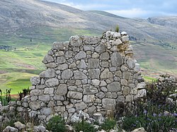
 Ruins at the archaeological site of
Tunanmarka | |
| Country | |
| Region | Junín |
| Province | Jauja |
| Founded | September 15, 1944 |
| Capital | Concho |
| Government | |
| • Mayor | Braulio Abilio Tabraj Flores |
| Area | |
| • Total | 30.07 km2 (11.61 sq mi) |
| Elevation | 3,470 m (11,380 ft) |
| Population (
2005 census) | |
| • Total | 1,357 |
| • Density | 45/km2 (120/sq mi) |
| Time zone | UTC-5 ( PET) |
| UBIGEO | 120432 |
Tunan Marca District is one of thirty-four districts of the province Jauja in Peru. [1]
See also
References
- ^ (in Spanish) Instituto Nacional de Estadística e Informática. Banco de Información Distrital Archived 2008-04-23 at the Wayback Machine. Retrieved April 11, 2008.