Photos • Location

Tschirn | |
|---|---|
 | |
 Coat of arms | |
Location of Tschirn within Kronach district 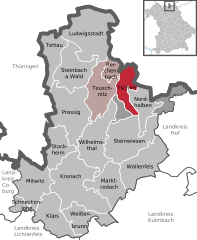 | |
 Tschirn  Tschirn | |
| Coordinates: 50°23′49″N 11°26′59″E / 50.39694°N 11.44972°E | |
| Country | Germany |
| State | Bavaria |
| Admin. region | Oberfranken |
| District | Kronach |
| Municipal assoc. | Teuschnitz |
| Subdivisions | 3 Ortsteile |
| Government | |
| • Mayor (2020–26) | Peter Klinger [1] ( CSU) |
| Area | |
| • Total | 20.13 km2 (7.77 sq mi) |
| Elevation | 598 m (1,962 ft) |
| Population (2022-12-31)
[2] | |
| • Total | 510 |
| • Density | 25/km2 (66/sq mi) |
| Time zone | UTC+01:00 ( CET) |
| • Summer ( DST) | UTC+02:00 ( CEST) |
| Postal codes | 96367 |
| Dialling codes | 09268 |
| Vehicle registration | KC |
| Website | www.tschirn-online.de |
Tschirn is a village in the district of Kronach in Oberfranken ( Bavaria, Germany). Located in the Franconian Forest range, it incorporates the sections Tschirn, Dobermühle and Gemeindeschneidmühle. The oldest historical record dates 1276.
References
- ^ Liste der ersten Bürgermeister/Oberbürgermeister in kreisangehörigen Gemeinden, Bayerisches Landesamt für Statistik, 15 July 2021.
- ^ Genesis Online-Datenbank des Bayerischen Landesamtes für Statistik Tabelle 12411-003r Fortschreibung des Bevölkerungsstandes: Gemeinden, Stichtag (Einwohnerzahlen auf Grundlage des Zensus 2011).
Towns and municipalities in
Kronach (district) | ||
|---|---|---|
 | ||
| International | |
|---|---|
| National | |
|
| This Kronach district location article is a stub. You can help Wikipedia by expanding it. |