Photos • Location
A Terra de Caldelas | |
|---|---|
|
Flag Coat of arms | |
 | |
| Country | |
| Autonomous community | Galicia |
| Province | Ourense |
| Capital | Castro Caldelas |
| Municipalities | |
| Area | |
| • Total | 313.25 km2 (120.95 sq mi) |
| Population (2019) | |
| • Total | 2,789 |
| • Density | 8.9/km2 (23/sq mi) |
| Time zone | UTC+1 ( CET) |
| • Summer ( DST) | UTC+2 ( CEST) |
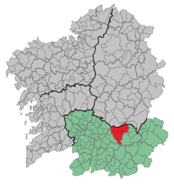
A Terra de Caldelas is a comarca in the Galician Province of Ourense. The overall population of this local region is 2,789 (2019). [1]
Municipalities
Castro Caldelas, Montederramo, Parada de Sil and A Teixeira.
References
- ^ "Poboación segundo nacionalidade e sexo (Fonte: INE. Padrón municipal de habitantes)". Instituto Galego de Estatística. Retrieved 2020-08-19.