 Takyeh Dowlat by
Kamal-ol-Molk | |
|
| |
| Location | Tehran, Persia ( Iran) |
|---|---|
| Coordinates | 35°40′42.65″N 51°25′15.93″E / 35.6785139°N 51.4210917°E |
| Owner | Royal court of Persia (Qajar dynasty) |
| Genre(s) |
Takyeh Theatre First Constituent assembly of Persia (Iran) |
| Construction | |
| Opened | 1868 |
| Demolished | 1946 |
| Architect | Hossein-Ali Mehrin |
The Takyeh Dowlat ( Persian: تکیه دولت, lit. 'State Takyeh' [1]) was a royal theater in Tehran, Iran. It was the most famous of all the ta'zieh performance spaces, for the Mourning of Muharram. It had a capacity for more than 4,000 people. Built in 1868 [2] by Naser al-Din Shah Qajar south-east of the Golestan Palace on the site of the Síyáh-Chál, the royal theater's sumptuous magnificence surpassed that of Europe's greatest opera houses in the opinion of many Western visitors. [3] Samuel Greene Wheeler Benjamin said on his first visit that it was comparable to Verona Arena.
According to Karim Pirnia, Hossein-Ali Mehrin was the architect of this building. [4]
Notable events
It was here that Reza Shah proclaimed the downfall of the Qajar dynasty. [5] The Takyeh Dowlat was destroyed in 1947 and a bank building was constructed on the site. [6]
Gallery
-

-
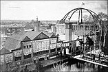 The Takyeh Dowlat adjacent to the Bād gīr Mansion in Golestan Palace
 -
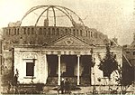 Main Entrance
 -
 Naser al-Din Shah Qajar's Funeral at the Takyeh Dowlat
 -
 Reza Shah Oath at Constituent assembly
 -
 Spectators at the Takyeh Dowlat
 -


References
-
^ Rayḥānah Shahristānī (1987).
Iran in days of old. p. 164.
the State Takyeh
- ^ Abbas Amanat. Pivot of the universe: Nasir al-Din Shah Qajar and the Iranian Monarchy, p. 435.
- ^ "TA'ZIA". Encyclopedia of Iranica. Retrieved 2010-06-15.
- ^ Mohammad Karim Pirnia, Sabk Shenasi Mi'mari Irani (Study of styles in Iranian architecture), M. Karim Pirnia. 2005. ISBN 964-96113-2-0 pp.134-135
- ^ Saeed Alizadeh, Alireza Pahlavani, Ali Sadrnia. Iran: a chronological history . p. 197.
- ^ The world encyclopedia of contemporary theatre, Volume 3 edited by Don Rubin, p. 215.
35°40′42.65″N 51°25′15.93″E / 35.6785139°N 51.4210917°E
|
| This article about a specific theatre building is a stub. You can help Wikipedia by expanding it. |