|
| This article is rated Start-class on Wikipedia's
content assessment scale. It is of interest to the following WikiProjects: | ||||||||||||||||
| |||||||||||||||||


Wondering how to edit this U.S. County Entry?
The
WikiProject U.S. Counties standards might help.
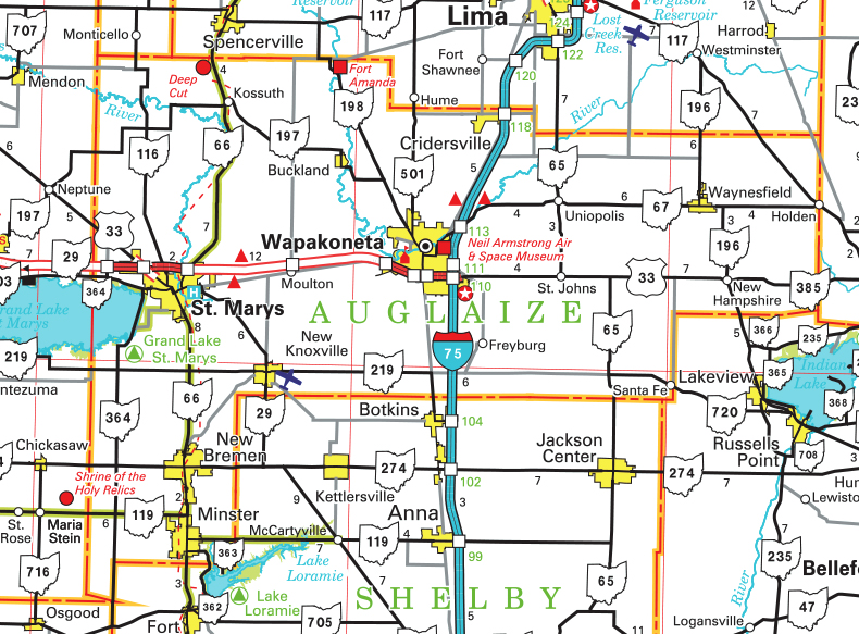
It appears that Darke and Auglaize counties touch — as you can see on Street View, there's an official highway sign reading something like "Leaving Auglaize County, Entering Darke County" along State Route 364. Nyttend ( talk) 15:12, 28 March 2010 (UTC)
- I think the sign may be erroneous. The census map shows Mercer County taking a small sliver of land in between Auglaize and Darke counties. The state highway map shows the same thing. The Mercer County and Auglaize County GIS websites agree.-- Ibagli ( Talk) 04:29, 28 April 2011 (UTC)
Hello fellow Wikipedians,
I have just modified 4 external links on Darke County, Ohio. Please take a moment to review my edit. If you have any questions, or need the bot to ignore the links, or the page altogether, please visit this simple FaQ for additional information. I made the following changes:
- Added archive https://web.archive.org/web/20110531210815/http://www.naco.org/Counties/Pages/FindACounty.aspx to http://www.naco.org/Counties/Pages/FindACounty.aspx
- Added
{{
dead link}}
tag to http://www.census.gov/geo/maps-data/data/docs/gazetteer/counties_list_39.txt - Added archive http://www.webcitation.org/6YSasqtfX?url=http://www.census.gov/prod/www/decennial.html to http://www.census.gov/prod/www/decennial.html
- Added archive https://web.archive.org/web/20130911234518/http://factfinder2.census.gov to http://factfinder2.census.gov
- Added archive https://web.archive.org/web/20150219234401/http://www.mydarkecountyohio.com/elected-officials/ to http://www.mydarkecountyohio.com/elected-officials/
When you have finished reviewing my changes, please set the checked parameter below to true or failed to let others know (documentation at {{
Sourcecheck}}).
This message was posted before February 2018.
After February 2018, "External links modified" talk page sections are no longer generated or monitored by InternetArchiveBot. No special action is required regarding these talk page notices, other than
regular verification using the archive tool instructions below. Editors
have permission to delete these "External links modified" talk page sections if they want to de-clutter talk pages, but see the
RfC before doing mass systematic removals. This message is updated dynamically through the template {{
source check}} (last update: 5 June 2024).
- If you have discovered URLs which were erroneously considered dead by the bot, you can report them with this tool.
- If you found an error with any archives or the URLs themselves, you can fix them with this tool.
Cheers.— InternetArchiveBot ( Report bug) 23:37, 6 December 2016 (UTC)
Hello fellow Wikipedians,
I have just modified 3 external links on Darke County, Ohio. Please take a moment to review my edit. If you have any questions, or need the bot to ignore the links, or the page altogether, please visit this simple FaQ for additional information. I made the following changes:
- Added archive http://www.webcitation.org/602xc6a8L?url=http://quickfacts.census.gov/qfd/states/39/39037.html to http://quickfacts.census.gov/qfd/states/39/39037.html
- Corrected formatting/usage for http://factfinder2.census.gov/
- Added archive https://web.archive.org/web/20150219234401/http://www.mydarkecountyohio.com/elected-officials/ to http://www.mydarkecountyohio.com/elected-officials/
When you have finished reviewing my changes, you may follow the instructions on the template below to fix any issues with the URLs.
This message was posted before February 2018.
After February 2018, "External links modified" talk page sections are no longer generated or monitored by InternetArchiveBot. No special action is required regarding these talk page notices, other than
regular verification using the archive tool instructions below. Editors
have permission to delete these "External links modified" talk page sections if they want to de-clutter talk pages, but see the
RfC before doing mass systematic removals. This message is updated dynamically through the template {{
source check}} (last update: 5 June 2024).
- If you have discovered URLs which were erroneously considered dead by the bot, you can report them with this tool.
- If you found an error with any archives or the URLs themselves, you can fix them with this tool.
Cheers.— InternetArchiveBot ( Report bug) 22:56, 4 September 2017 (UTC)
Folks this may come as a surprise to those of you who can’t read a map, but darke and auglaize do not touch. If they did than Mercer and shelby counties would not touch which they do. If you drive on state route 364 and Mercer darke co line road you’ll see the property lines that follow the Greenville treaty line which is the Mercer county line thus negating any claims that darke and auglaize touch. Thank you 206.51.164.42 ( talk) 13:32, 2 November 2021 (UTC)
- I don't see anywhere that it says they "touch"? Please explain what it is that you wish to have changed. - Adolphus79 ( talk) 14:31, 2 November 2021 (UTC)
Darke County does not border Auglaize County because Mercer County follows the Greenville Treaty Line till it intersects the Mercer darke county line thus allowing Mercer to border Shelby county thus making it geographically impossible for darke to border auglaize 206.51.164.42 ( talk) 15:49, 17 November 2021 (UTC)
- As mentioned in the section directly above, where does it say they border each other? The only mention of Auglaize is that they are adjacent, which is correct (Auglaize is northeast of Darke). - Adolphus79 ( talk) 16:32, 18 November 2021 (UTC)
- Start-Class United States articles
- Mid-importance United States articles
- Start-Class United States articles of Mid-importance
- Start-Class Ohio articles
- Mid-importance Ohio articles
- WikiProject Ohio articles
- Start-Class U.S. counties articles
- Unknown-importance U.S. counties articles
- WikiProject U.S. counties articles
- WikiProject United States articles