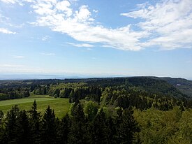
Photos • Location
| Table Jura | |
|---|---|
 | |
| Highest point | |
| Peak | Lemberg |
| Elevation | 1,015 m (3,330 ft) |
| Coordinates | 48°09′02″N 8°44′57″E / 48.15056°N 8.74917°E |
| Geography | |
| Countries | Germany and Switzerland |
| Cantons/ States | Basel-Landschaft, Aargau, Schaffhausen, Baden-Württemberg and Bavaria |
| Range coordinates | 50°16′N 10°58′E / 50.267°N 10.967°E |
The so-called Table Jura or Plateau Jura ( German: Tafeljura; French: le Jura tabulaire) is the northeastern extension of the Jura Mountains. It stands in opposition to the folded Jura (Faltenjura) of the Jura range proper. [1]
The Table Jura stretches across the Swiss cantons of Basel-Landschaft, Aargau, and Schaffhausen ( Randen) into southern Germany ( Baden-Württemberg, Bavaria), including the Hoher Randen, Baar, the Swabian Jura and the Franconian Jura. The Table Jura thus ranges from near the Swiss city of Basel to the German city of Coburg.
References
- ^ Sommaruga, A. (1999-03-15). "Décollement tectonics in the Jura forelandfold-and-thrust belt". Marine and Petroleum Geology. 16 (2): 111–134. doi: 10.1016/S0264-8172(98)00068-3. ISSN 0264-8172.