Târgu Neamț | |
|---|---|
.jpg) Neamț Citadel | |
 Coat of arms | |
 Location in Neamț County | |
 Târgu Neamț Location in Romania | |
| Coordinates: 47°12′9″N 26°21′31″E / 47.20250°N 26.35861°E | |
| Country | Romania |
| County | Neamț |
| Government | |
| • Mayor (2020–2024) | Vasilică Harpa [1] ( PSD) |
| Area | 47.31 km2 (18.27 sq mi) |
| Elevation | 365 m (1,198 ft) |
| Population (2021-12-01)
[2] | 18,029 |
| • Density | 380/km2 (990/sq mi) |
| Time zone | EET/ EEST (UTC+2/+3) |
| Postal code | 615200 |
| Area code | (+40) 02 33 |
| Vehicle reg. | NT |
| Website |
www |
Târgu Neamț (Romanian pronunciation: [ˌtɨrɡu ˈne̯amt͡s]; German: Niamtz, Hungarian: Németvásár, Hebrew: נאמץ טרגו, Latin: Ante Castrum Nempch) is a town in Neamț County, Western Moldavia, Romania, on the river Neamț. It had, as of 2021 [update], a population of 18,029. Three villages are administered by the town: Blebea, Humulești, and Humuleștii Noi.
History
| Year | Pop. | ±% |
|---|---|---|
| 1912 | 9,095 | — |
| 1930 | 9,475 | +4.2% |
| 1948 | 8,948 | −5.6% |
| 1956 | 10,373 | +15.9% |
| 1966 | 12,877 | +24.1% |
| 1977 | 14,951 | +16.1% |
| 1992 | 22,282 | +49.0% |
| 2002 | 22,634 | +1.6% |
| 2011 | 18,232 | −19.4% |
| 2021 | 18,029 | −1.1% |
| Source: Census data | ||
Originally a market town, hence its name (in Romanian " târg" = market), it had an important role in Moldavian culture. It was first mentioned in a late-14th century document.
The name neamț is a generic name of Slavic origin for the German people in the Romanian language. This has led to speculation of a German foundation of Târgu Neamț, according to which Saxon colonists crossed the Carpathians from the Bistrița area and built a commercial township. Some Romanian historians, including Bogdan Petriceicu Hasdeu consider that Târgu Neamț was probably a German settlement from the 13th century, when the Teutonic Order made incursions from Transylvania against the Cumanic peoples that were living in Moldavia.[ citation needed]
Nowadays, historians disagree with this possibility mostly because of the long-lasting influences of the communist-nationalistic historiography which refused to accept the town was anything else than a Romanian-founded settlement.
Access
The town is located at the crossing of two
national roads:
DN15B
![]() and
DN15C
and
DN15C
![]() . The planned
East-West Motorway will bypass the town on its south when completed, providing access to
Iași (to the east) and
Târgu Mureș to the west. The railroad station is the terminus station of
CFR
Line 517 linking it to
Pașcani via an
electrified railway.
. The planned
East-West Motorway will bypass the town on its south when completed, providing access to
Iași (to the east) and
Târgu Mureș to the west. The railroad station is the terminus station of
CFR
Line 517 linking it to
Pașcani via an
electrified railway.
Tourism and attractions
- The Neamț Fortress (Cetatea Neamțului) was built in the 14th century by Voivode Petru I (possibly on the ruins of a smaller Teutonic castle), and is located on the north bank of the Neamț River.
- Târgu Neamț is an appropriate starting point for trips to the monasteries in the region, located all on an average 15 km (9.3 mi) radius: Neamț Monastery, Secu Monastery, Agapia Monastery, Văratec Monastery, Sihăstria Monastery, and Sihla Skete. It is close to the Ceahlău Massif, Durău, and the Bistrița Valley.
- Ion Creangă memorial house in Humulești, across the Ozana river: This is the house where the famous Romanian writer was born and where he spent his childhood. The stories from Ion Creangă's masterpiece, Amintiri din copilărie ("Memories of my childhood"), revolve around Humulești, Târgu Neamț, and the surrounding villages.
- Monumentul Eroilor (Heroes' Monument): an obelisk that commemorates the Romanian soldiers who fought in World War I is found on Pleșu Hill, near the Pometea suburb. It commands views of the town and the surrounding mountains.
- The Vânători-Neamț Natural Park, housing a herd of wisent, the European bisons that once roamed the Eastern Carpathians.
- The Nicolae Popa ethnographic museum în Târpești.
Natives
- Dumitru Botez
- Constantin Cojocariu
- Ana Conta-Kernbach
- Daniel Corbu
- Dumitru A. Cornelson
- Ion Creangă
- Constantin Crișan
- Ștefan Dănilă
- Emanoil Dumitrescu
- Florin Gheorghiță
- Moshe Idel
- Irving Layton
- Gabriela Mihalschi
- Mariana Simionescu
- Valentin Ursache
- Ioan Vieru
Gallery
-
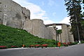 Neamț Citadel, located on Pleșu Hill
 -
 View from Citadel
 -
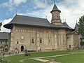 Neamț Monastery, located 10 km west of Târgu Neamț
 -


References
- ^ "Results of the 2020 local elections". Central Electoral Bureau. Retrieved 8 June 2021.
- ^ "Populaţia rezidentă după grupa de vârstă, pe județe și municipii, orașe, comune, la 1 decembrie 2021" (XLS). National Institute of Statistics.

| Authority control databases: National |
|---|