Photos • Location

39°08′02″N 121°56′31″W / 39.13389°N 121.94194°W
Sycamore | |
|---|---|
 Sycamore Location in California  Sycamore Sycamore (the United States) | |
| Coordinates: 39°08′02″N 121°56′31″W / 39.13389°N 121.94194°W | |
| Country | United States |
| State | California |
| County | Colusa County |
| Elevation | 49 ft (15 m) |
Sycamore (formerly, Loch-loch) is a former settlement in Colusa County, California. It lies near the mouth of Sycamore Slough, at an elevation of 49 feet (15 m). Sycamore was a farming community in the late nineteenth century and once had a mill, church, school, and a nearby station on the Northern Electric railway branch to Colusa. [2] The Sycamore post office operated from 1871 to 1960. [3] Today nothing remains at the Sycamore townsite, which is located on California State Route 45 on the south side of its crossing of Sycamore Creek.
References
- ^ U.S. Geological Survey Geographic Names Information System: Sycamore, California
- ^ McComish, Charles Davis; Lambert, Rebecca T. (1918). History of Colusa and Glenn Counties, California. Los Angeles, CA: Historic Record Company.
- ^ Forte, Jim. "Jim Forte Postal History". Postalhistory.com. Retrieved June 23, 2024.
Municipalities and communities of
Colusa County, California, United States | ||
|---|---|---|
| Cities | 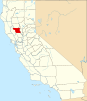 | |
| CDPs | ||
|
Unincorporated communities | ||
|
Indian reservations | ||
| Ghost towns | ||
| Footnotes | ‡This populated place also has portions in an adjacent county or counties | |
|
| This Colusa County, California-related article is a stub. You can help Wikipedia by expanding it. |