Photos • Location
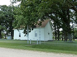
Sterling Congregational Church | |
 | |
| Location | County Road 151, Sterling Township, Minnesota |
|---|---|
| Nearest city | Amboy, Minnesota |
| Coordinates | 43°53′55″N 94°3′25″W / 43.89861°N 94.05694°W |
| Area | 1.5 acres (0.61 ha) |
| Built | 1867 |
| MPS | Blue Earth County MRA |
| NRHP reference No. | 80001958 [1] |
| Added to NRHP | July 28, 1980 |
Sterling Congregational Church is a historic church in Sterling Township, Blue Earth County, Minnesota, United States, built in 1867. It was listed on the National Register of Historic Places in 1980. It was nominated for being a rare surviving example of rural community buildings from the settlement era prior to the county's first railroad. [2]
References
- ^ "National Register Information System". National Register of Historic Places. National Park Service. July 9, 2010.
-
^ Gimmestad, Dennis (January 1980).
"Minnesota Historic Properties Inventory Form: Sterling Church". National Park Service. Retrieved October 11, 2015.
{{
cite journal}}
: Cite journal requires|journal=( help)
Categories:
- Churches completed in 1867
- Churches in Blue Earth County, Minnesota
- Congregational churches in Minnesota
- Greek Revival church buildings in Minnesota
- Churches on the National Register of Historic Places in Minnesota
- Wooden churches in Minnesota
- National Register of Historic Places in Blue Earth County, Minnesota
- 1867 establishments in Minnesota
- Minnesota Registered Historic Place stubs
- Minnesota church stubs


