Stadtschlaining | |
|---|---|
 | |
 Coat of arms | |
 Location within
Oberwart district | |
 Stadtschlaining Location within Austria | |
| Coordinates: 47°19′N 16°16′E / 47.317°N 16.267°E | |
| Country | Austria |
| State | Burgenland |
| District | Oberwart |
| Government | |
| • Mayor | Herbert Dienstl |
| Area | |
| • Total | 42.07 km2 (16.24 sq mi) |
| Elevation | 409 m (1,342 ft) |
| Population (2018-01-01)
[2] | |
| • Total | 1,980 |
| • Density | 47/km2 (120/sq mi) |
| Time zone | UTC+1 ( CET) |
| • Summer ( DST) | UTC+2 ( CEST) |
| Postal code | 7461 |
| Website | www.stadtschlaining.at |
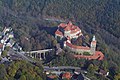
Stadtschlaining ( Hungarian: Városszalónak, Város-Szalónak) is a town in the district of Oberwart in the Austrian state of Burgenland. The Burg Schlaining, built by Henry I Kőszegi, is located there, which hosts the Austrian Study Centre for Peace and Conflict Resolution (ASPR) and the Peace Museum.
Population
The town is located in southern Burgenland on the western slopes of the Günser Gebirge.
Municipal division
The municipal area comprises the following five villages (in brackets: number of inhabitants as of January 1, 2023)
- Altschlaining (275)
- Drumling (231)
- Goberling (393)
- Neumarkt im Tauchental (388)
- Stadtschlaining (678)
The municipality consists of the cadastral communities of Altschlaining, Drumling, Goberling, Neumarkt im Tauchental and Stadtschlaining.
| Year | Pop. | ±% |
|---|---|---|
| 1869 | 3,586 | — |
| 1880 | 3,633 | +1.3% |
| 1890 | 3,675 | +1.2% |
| 1900 | 3,566 | −3.0% |
| 1910 | 3,121 | −12.5% |
| 1923 | 2,795 | −10.4% |
| 1934 | 2,695 | −3.6% |
| 1939 | 2,567 | −4.7% |
| 1951 | 2,424 | −5.6% |
| 1961 | 2,255 | −7.0% |
| 1971 | 2,273 | +0.8% |
| 1981 | 2,203 | −3.1% |
| 1991 | 2,284 | +3.7% |
| 2001 | 2,093 | −8.4% |
| 2011 | 2,064 | −1.4% |
References
- ^ "Dauersiedlungsraum der Gemeinden Politischen Bezirke und Bundesländer - Gebietsstand 1.1.2018". Statistics Austria. Retrieved 10 March 2019.
- ^ "Einwohnerzahl 1.1.2018 nach Gemeinden mit Status, Gebietsstand 1.1.2018". Statistics Austria. Retrieved 9 March 2019.
Gallery
-
 Center of Stadtschlaining
 -
 Catholic parish church
 -
 Protestant parish church
 -

.JPG)


| International | |
|---|---|
| National | |
|
| This Burgenland location article is a stub. You can help Wikipedia by expanding it. |
|
| This Austrian history article is a stub. You can help Wikipedia by expanding it. |
|
| This Hungarian history article is a stub. You can help Wikipedia by expanding it. |
|
| This article related to Jewish history is a stub. You can help Wikipedia by expanding it. |