Southport Historic District | |
 Southport Historic District, June 2010 | |
  | |
| Location | Roughly bounded by Cape Fear River, Rhett, Bay, Short and Brown Sts., Southport, North Carolina |
|---|---|
| Coordinates | 33°55′09″N 78°01′13″W / 33.91917°N 78.02028°W |
| Area | 112 acres (45 ha) |
| Architect | Robbins, A.J.; Et al. |
| NRHP reference No. | 80002801 [1] |
| Added to NRHP | November 25, 1980 |
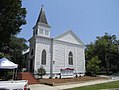
Southport Historic District is a national historic district located at Southport, Brunswick County, North Carolina. The district encompasses 161 contributing buildings, 3 contributing sites, and 1 contributing object. Over half of the structures in the historic district date from the 1885-1905 period. It includes residential, commercial, and institutional buildings and is considered the best example of a Victorian coastal town in North Carolina. Notable buildings include the River Pilots Tower and Building (1940s), Frying Pan Lightship (20th century), Fort Johnston Officers Quarters (c. 1805-09), Walker-Pike House (c. 1800-20), Brunswick Inn (c. 1859), Fort Johnston Hospital (c. 1852-1860), Former Brunswick County Court House (c. 1854), Saint Philips Episcopal Church (c. 1860, 1894–96), Trinity Methodist Church (1888-1890), and the Adkins-Ruark House (1890). [2]
It was added to the National Register of Historic Places in 1980. [1]
-
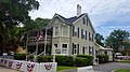 W. Newton House, 2016
 -
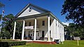
 Trinity United Methodist Church, 2016
 -
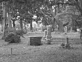 Smithfield Burial Ground, 2010
 -
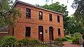
 T. St. George House, 2016
 -
 S. Swain House, 2016
 -
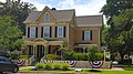
 Richard Bensell House, 2016
 -
 Morse Cottage, 2016
 -
 Julius Newton House, 2016
 -
 Former Brunswick County Jail, 2016
 -
 Daniel Bender House, 2016
 -
 Captain Melvin Craig House, 2016
 -
 Amuzu Theater, 2010
 -
 Adkins-Ruark House, 2016
 -
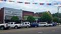 Watson's Pharmacy & Commercial Block, 2016
 -
 St Phillips Episcopal Church, 2016
 -
 Southport Masonic Lodge, 2016


- ^ a b "National Register Information System". National Register of Historic Places. National Park Service. July 9, 2010.
- ^ Carl Lounsbury (June 1980). "Southport Historic District" (pdf). National Register of Historic Places - Nomination and Inventory. North Carolina State Historic Preservation Office. Retrieved August 1, 2014.

- Historic districts on the National Register of Historic Places in North Carolina
- Buildings and structures in Brunswick County, North Carolina
- National Register of Historic Places in Brunswick County, North Carolina
- Houses in Brunswick County, North Carolina
- Eastern North Carolina Registered Historic Place stubs