Photos • Location
Sourou | |
|---|---|
Province | |
 Location in Burkina Faso | |
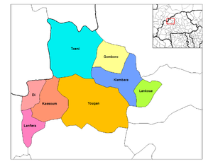
 Provincial map of its departments | |
| Country | |
| Region | Boucle du Mouhoun |
| Capital | Tougan |
| Area | |
| • Province | 2,227 sq mi (5,768 km2) |
| Population (2019 census)
[1] | |
| • Province | 284,947 |
| • Density | 130/sq mi (49/km2) |
| • Urban | 26,347 |
| Time zone | UTC+0 (GMT 0) |
Sourou is one of the 45 provinces of Burkina Faso, located in its Boucle du Mouhoun.
Its capital is Tougan.
Education
In 2011 the province had 162 primary schools and 17 secondary schools. [2]
Healthcare
In 2011 the province had 27 health and social promotion centers (Centres de santé et de promotion sociale), 5 doctors and 89 nurses. [3]
Departments
Sourou is divided into 8 departments:
See also
References
- ^ Citypopulation.de Population of provinces in Boucle du Mouhoun Region
- ^ "La région du Boucle du Mouhoun en chiffres" (PDF). Institut National de la Statistique et de la Démographie (INSD). 2011. p. 6. Archived from the original (PDF) on 2012-11-13.
- ^ "La région du Boucle du Mouhoun en chiffres" (PDF). Institut National de la Statistique et de la Démographie (INSD). 2011. p. 6. Archived from the original (PDF) on 2012-11-13.
13°04′N 3°04′W / 13.067°N 3.067°W