| Sokol Fortress | |
|---|---|
| Šćepan Polje, Montenegro | |
|
| |
 Sokol Fortress Location in Montenegro | |
| Coordinates | 43°20′38″N 18°51′07″E / 43.344°N 18.852°E |
| Type | fortress |
| Site history | |
| Built for | Bosnian medieval state |
| In use | 15th century |
| Materials | Limestone |
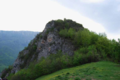
Sokol was a hill-side fortress located near the confluence of the rivers Piva and Tara, today south of the village of Šćepan Polje at the border of Montenegro and Bosnia and Herzegovina. It's also referred to as Sokol grad and Soko.
The fortress was believed to have been mentioned as međurječje lit. 'the place between the rivers' in 10th century sources, and became known as Sokol under the rule of Stjepan Vukčić Kosača in the 15th century. Below the fortress is the Zagrađe Monastery, a monastery of the Serbian Orthodox Church dedicated to St. John the Baptist. [1]
Gallery
-
 Ruins of the medieval fortress Soko Grad
 -
 Location of Fortress Soko in 1444, within the Duchy of Saint Sava
 -
 Fortress Soko in 1441, during the breakthrough of Herzog Šćepan to Lordship of Zeta.
 -
 Map of the Sanjak of Herzegovina in 1600 indicating Soko near Piva and Tara


References
- ^ "Manastir Zagrađe" (in Montenegrin). Plužine, Montenegro: Piva Nature Park.
|
| This military base or fortification article is a stub. You can help Wikipedia by expanding it. |
|
| This Montenegro location article is a stub. You can help Wikipedia by expanding it. |