Photos • Location


You can help expand this article with text translated from
the corresponding article in German. (November 2016) Click [show] for important translation instructions.
|
Sankt Gotthard im Mühlkreis | |
|---|---|
 | |
 Coat of arms | |
 Sankt Gotthard im Mühlkreis Location within Austria | |
| Coordinates: 48°22′10″N 14°07′02″E / 48.36944°N 14.11722°E | |
| Country | Austria |
| State | Upper Austria |
| District | Urfahr-Umgebung |
| Government | |
| • Mayor | Johannes Rechberger ( ÖVP) |
| Area | |
| • Total | 11.99 km2 (4.63 sq mi) |
| Elevation | 473 m (1,552 ft) |
| Population (2018-01-01)
[2] | |
| • Total | 1,332 |
| • Density | 110/km2 (290/sq mi) |
| Time zone | UTC+1 ( CET) |
| • Summer ( DST) | UTC+2 ( CEST) |
| Postal code | 4112 |
| Area code | 0 72 34 |
| Vehicle registration | UU |
| Website | www.sanktgotthard.at |
Sankt Gotthard im Mühlkreis is a municipality in the district of Urfahr-Umgebung in Upper Austria, Austria.
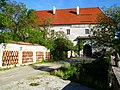
Attractions include Schloss Eschelberg, a stately home built in 1596, and the ruined 13th-century Rottenegg Castle. [3]
Villages
The municipality contains the following villages:
Population
| Year | Pop. | ±% |
|---|---|---|
| 1869 | 779 | — |
| 1890 | 790 | +1.4% |
| 1910 | 756 | −4.3% |
| 1923 | 761 | +0.7% |
| 1934 | 742 | −2.5% |
| 1939 | 688 | −7.3% |
| 1951 | 966 | +40.4% |
| 1971 | 975 | +0.9% |
| 1991 | 1,125 | +15.4% |
| 2001 | 1,299 | +15.5% |
| 2007 | 1,314 | +1.2% |
Gallery
-
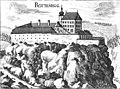 Rottenegg Castle, now ruined
 -
 Schloss Eschelberg, built in 1596
 -
 Schloss Eschelberg forest house
 -
 Medieval mill house
 -
 Former prison


References
- ^ "Dauersiedlungsraum der Gemeinden Politischen Bezirke und Bundesländer - Gebietsstand 1.1.2018". Statistics Austria. Retrieved 10 March 2019.
- ^ "Einwohnerzahl 1.1.2018 nach Gemeinden mit Status, Gebietsstand 1.1.2018". Statistics Austria. Retrieved 9 March 2019.
- ^ "Oberösterreich unbewegliche und archäologische Denkmale unter Denkmalschutz" (PDF). Bundesdenkmalamtes Österreich. 28 June 2013. p. 136.
Wikimedia Commons has media related to
Sankt Gotthard im Mühlkreis.
| International | |
|---|---|
| National | |
|
| This Upper Austria location article is a stub. You can help Wikipedia by expanding it. |