Photos • Location

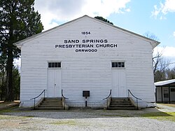
Sand Spring Presbyterian Church | |
 Sand Spring Presbyterian Church, Orwood, MS, USA. | |
| Nearest city | Water Valley, Mississippi |
|---|---|
| Coordinates | 34°15′24″N 89°42′55″W / 34.25667°N 89.71528°W |
| Area | 1.4 acres (0.57 ha) |
| Built | 1854 |
| Architect | William Turner |
| Architectural style | Vernacular rural church |
| NRHP reference No. | 93000083 [1] |
| Added to NRHP | February 25, 1993 |
Sand Spring Presbyterian Church is a historic church in Water Valley, Mississippi.
It was built in 1854 and added to the National Register of Historic Places in 1993. The church is also registered by the Presbyterian Historical Society under the American Presbyterian/Reformed Historical Sites Registry as Site No. 371. [2]
-
Left side
-
NRHP marker
References
- ^ "National Register Information System". National Register of Historic Places. National Park Service. July 9, 2010.
- ^ Presbyterian Historical Society, " [1]". The American Presbyterian/Reformed Historical Sites Registry. Retrieved 16 March 2014.
Wikimedia Commons has media related to
Sand Spring Presbyterian Church.
Categories:
- Presbyterian churches in Mississippi
- Churches on the National Register of Historic Places in Mississippi
- Churches completed in 1854
- Lafayette County, Mississippi
- National Register of Historic Places in Lafayette County, Mississippi
- Mississippi Registered Historic Place stubs
- Southern United States church stubs
- Mississippi building and structure stubs


