Photos • Location

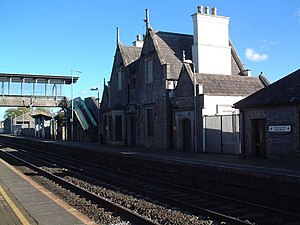
Sallins and Naas railway station building built in the 1840s
This article relies largely or entirely on a
single source. (July 2015) |
 | |
| General information | |
| Location |
Sallins,
County Kildare, W91 XY28 Ireland |
| Coordinates | 53°14′49″N 6°39′53″W / 53.24694°N 6.66472°W |
| Owned by | Iarnród Éireann |
| Operated by | Iarnród Éireann |
| Platforms | 2 |
| Tracks | 2 |
| Bus routes | 3 |
| Bus operators | TFI Local Link |
| Connections |
|
| Construction | |
| Structure type | At-grade |
| Other information | |
| Station code | SALNS |
| Fare zone | Suburban 4 |
| History | |
| Original company | Great Southern and Western Railway |
| Pre-grouping | Great Southern and Western Railway |
| Post-grouping | Great Southern Railways |
| Key dates | |
| 1846 | Original station opened |
| 9 June 1947 | Closed to goods |
| 1963 | Original station fully closed |
| 31 March 1976 | Sallins Train Robbery |
| 1994 | Relocated station opens |
South Western Commuter | ||||||||||||||||||||||||||||||||||||||||||||||||||||||||||||||||||||||||||||||||||||||||||||||||||||||||||||||||||||||||||||||||||||||||||||||||||||||||||||||||||||||||||||||||||||||||||||||||||||||||||||||||||||||||||||||||||||||||
|---|---|---|---|---|---|---|---|---|---|---|---|---|---|---|---|---|---|---|---|---|---|---|---|---|---|---|---|---|---|---|---|---|---|---|---|---|---|---|---|---|---|---|---|---|---|---|---|---|---|---|---|---|---|---|---|---|---|---|---|---|---|---|---|---|---|---|---|---|---|---|---|---|---|---|---|---|---|---|---|---|---|---|---|---|---|---|---|---|---|---|---|---|---|---|---|---|---|---|---|---|---|---|---|---|---|---|---|---|---|---|---|---|---|---|---|---|---|---|---|---|---|---|---|---|---|---|---|---|---|---|---|---|---|---|---|---|---|---|---|---|---|---|---|---|---|---|---|---|---|---|---|---|---|---|---|---|---|---|---|---|---|---|---|---|---|---|---|---|---|---|---|---|---|---|---|---|---|---|---|---|---|---|---|---|---|---|---|---|---|---|---|---|---|---|---|---|---|---|---|---|---|---|---|---|---|---|---|---|---|---|---|---|---|---|---|---|---|---|---|---|---|---|---|---|---|---|---|---|---|---|---|---|
| ||||||||||||||||||||||||||||||||||||||||||||||||||||||||||||||||||||||||||||||||||||||||||||||||||||||||||||||||||||||||||||||||||||||||||||||||||||||||||||||||||||||||||||||||||||||||||||||||||||||||||||||||||||||||||||||||||||||||

Sallins and Naas railway station is located in the centre of the village of Sallins, County Kildare and also serves Naas, 3 km (2 miles) away. The station is in Dublin Short Hop Zone and as a result is the busiest station on the Kildare Line.
Feeder bus
A feeder bus operates between the station and the centre of Naas (Poplar Square & Post Office). There are several journeys in each direction throughout the day. The bus does not operate on Sundays.
History
Originally called "Sallins", it opened on 4 August 1846 [1] and was the junction for the Tullow branch, which included the original Naas station. It closed in 1963, and was renamed Sallins & Naas upon re-opening in 1994. [1]
Services
| Preceding station |
|
Following station | ||
|---|---|---|---|---|
|
Hazelhatch & Celbridge |
InterCity Dublin–Westport/Galway railway line Peak times only |
Newbridge | ||
|
Commuter South Western Commuter |
||||