You can help expand this article with text translated from
the corresponding article in French. (July 2014) Click [show] for important translation instructions.
|
Saint-Béat | |
|---|---|
Part of
Saint-Béat-Lez | |
.JPG) The
Garonne river and the village of Saint-Béat | |
.svg) Coat of arms | |
 Saint-Béat  Saint-Béat | |
| Coordinates: 42°54′54″N 0°41′36″E / 42.915°N 0.6933°E | |
| Country | France |
| Region | Occitania |
| Department | Haute-Garonne |
| Arrondissement | Saint-Gaudens |
| Canton | Bagnères-de-Luchon |
| Commune | Saint-Béat-Lez |
| Area 1 | 7.37 km2 (2.85 sq mi) |
| Population (2016)
[1] | 345 |
| • Density | 47/km2 (120/sq mi) |
| Time zone | UTC+01:00 ( CET) |
| • Summer ( DST) | UTC+02:00 ( CEST) |
| Postal code | 31440 |
| Elevation | 476–1,760 m (1,562–5,774 ft) (avg. 500 m or 1,600 ft) |
| 1 French Land Register data, which excludes lakes, ponds, glaciers > 1 km2 (0.386 sq mi or 247 acres) and river estuaries. | |
Saint-Béat (French pronunciation: [sɛ̃ bea]; Gascon: Sent Biat) is a former commune in the Haute-Garonne department in southwestern France. On 1 January 2019, it was merged into the new commune Saint-Béat-Lez. [2]
- Château de Saint-Béat, 12th century castle
- The Pic du Gar is a striking limestone mountain in the area.
Saint-Béat is renowned for its marble quarries, which have been in operation since Roman times. Although quarrying activity is now reduced, various marbles were or are still extracted from the municipality:
- The statuary white, or bluish-white, is the most prestigious marble from the municipality. For instance, it has been used to adorn the Palace of Versailles and the Grand Trianon. Its white or light gray color makes it a marble suitable for substituting Carrara marble, even though its coarser grain makes it harder and more challenging to sculpt.
- Blue Turquin marble: it is a bluish-gray marble that can range up to dark gray.
- The surroundings of Saint-Béat also host quarries with marbles of various colors: the black from Loures-Barousse, the yellow from Bagiry, the red from Cierp, as well as green and white from Lez...
Every year, a sculpture and marble festival takes place in July in Saint-Béat. It welcomes sculptors, including some internationally renowned artists, who have three weeks to create a piece using blocks of local marble. The festival also offers workshops for those interested in learning the art of sculpture.
-
 Roman breccia
 -
 White statuary marble
 -
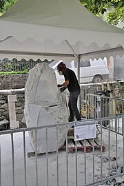 Work in progress at sculpture and marble Festival 2023
 -
 Sculpture and marble Festival 2023
 -
 Sculpture and marble Festival 2023
 -
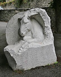 Winner of a previous sculpture and marble festival, exhibited near the Garonne river


| Year | Pop. | ±% |
|---|---|---|
| 1962 | 687 | — |
| 1968 | 755 | +9.9% |
| 1975 | 611 | −19.1% |
| 1982 | 543 | −11.1% |
| 1990 | 547 | +0.7% |
| 1999 | 364 | −33.5% |
| 2006 | 394 | +8.2% |
| 2007 | 398 | +1.0% |
| 2008 | 394 | −1.0% |
| 2012 | 387 | −1.8% |
| 2016 | 345 | −10.9% |
_-_Fonds_Ancely_-_B315556101_A_MALBOS_1_010.jpg)
- ^ Téléchargement du fichier d'ensemble des populations légales en 2016, INSEE
- ^ Arrêté préfectoral 30 April 2018 (in French)
| International | |
|---|---|
| National | |
| Other | |
|
| This Haute-Garonne geographical article is a stub. You can help Wikipedia by expanding it. |