Photos • Location
Bydel Søndre Nordstrand | |
|---|---|
 | |
 | |
| Coordinates: 59°49′48″N 10°47′36″E / 59.8299°N 10.7934°E | |
| Country | Norway |
| City | Oslo |
| Area | |
| • Total | 18.42 km2 (7.11 sq mi) |
| Population (2020) | |
| • Total | 39,066 |
| • Rank | 10/15 |
| • Density | 1,958/km2 (5,070/sq mi) |
| Time zone | UTC+1 ( CET) |
| • Summer ( DST) | UTC+2 ( CEST) |
| ISO 3166 code | NO-030115 |
| Website | bsn.oslo.kommune.no |
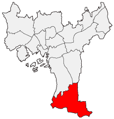
Søndre Nordstrand (Southern Nordstrand) is a borough of the city of Oslo, Norway. It is the southernmost borough of Oslo, bordering Nordstrand. As of 2020 it has 39,066 inhabitants [1] and the highest rate of immigrant population at 56%. [2] It is the only borough of Oslo that has a majority-minority population. [3]
Neighborhoods in Søndre Nordstrand include:
References
- ^ Municipality of Oslo (2020). "Befolkningen etter bydel, kjønn og aldersgrupper 1.1.2020" (in Norwegian). Retrieved 29 April 2020.
- ^ Norwegian Broadcasting Corporation (NRK) (2020). "Stopper bosetting av flyktninger i bydeler med mange innvandrere 17.1.2020" (in Norwegian). Retrieved 30 April 2020.
- ^ Aftenposten (2013). "Her har flertallet innvandrerbakgrunn 25.4.2013" (in Norwegian). Retrieved 30 April 2020.
