Ras Abrouq
رأس أبروق | |
|---|---|

Richard Serra's East-West/West-East sculpture seen in Ras Abrouq at night | |
 Ras Abrouq Location in Qatar | |
| Coordinates: 25°34′41″N 50°50′46″E / 25.57806°N 50.84611°E | |
| Country | |
| Municipality | Al-Shahaniya |
| Zone | Zone 72 |
| District no. | 203 |
| Area | |
| • Total | 11.6 sq mi (30.1 km2) |
| Time zone | UTC+3 ( AST) |
Ras Abrouq ( Arabic: رأس أبروق; also known as Bir Zekreet) [2] is the northernmost extension of the Zekreet Peninsula, a stretch of land to the north of Dukhan in Qatar. [3] It has a beach of the same name [2] and various archaeological sites. Since the 21st century it has functioned as a tourist site. [2]
Large parts of its territory are legally protected areas that are dedicated to a nature reserve for wild deer. [4] Richard Serra's East-West/West-East sculpture was completed in Brouq Nature Reserve in 2014 at the behest of the Qatar Museums Authority. [5]
In Arabic, the word "ras" translates to "head", and in this context is used to refer to a cape. The other constituent, "abrouq", is derived from the nearby range of light-colored hills in the Zekreet Peninsula (also known as the Abrouq Peninsula). [3]
Its name is also spelled as Ras Broog. [3]
Ras Abrouq is a cape located on the tip of the Zekreet Peninsula near the city of Dukhan. It is 70 km west of the Qatari capital of Doha. [6] Located south of Ras Abrouq is the village of Zekreet. [3]
Ras Abrouq is one of the most extensive Neolithic sites in Qatar. It has one of the highest proportions of Ubaid potsherds in Qatar. [7] Excavations in the 1970s revealed a ring-like structure, hearths, Ubaid pottery, cairns, and stone tools dating to the Neolithic period. Many fish bones and snail shells were also recovered. [8] G.H. Smith, an excavator of the site, suggested that it was a seasonal encampment and that its inhabitants had trade relations with nearby civilizations. [8] [9]
Further archaeological excavations yielded Barbar ceramics originating from the Dilmun civilization dating to the third millennium BC. [10] A number of chambered cairns dating to the same period contained 108 beads made of stone and shell. [11]
Excavations conducted during the mid-20th century uncovered potsherds of Seleucid characteristic and a cairnfield consisting of 100 burial mounds dating to the 3rd century BC. [12] [13] The relatively large number of cairns suggest a sizable sea-faring community prevailed in the area during this period. [14]
Further excavations revealed a fishing station dating to c. 140 BC which was used by foreign vessels to dry fish during the Sasanian period. [15] A number of stone structures and large quantities of fish bones were recovered from the site. [14]
-
 Ras Abrouq contains a high concentration of ostriches
 -
 Hills in Ras Arouq
 -
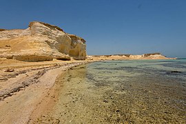 Sandstone cliffs at the cape
.jpg)


- ^ "District Area Map". Ministry of Development Planning and Statistics. Retrieved 13 March 2019.
- ^ a b c Natural Landmarks Archived 3 July 2015 at the Wayback Machine Qatar Tourism
- ^ a b c d "Geographic Information System". Ministry of Development Planning and Statistics. Archived from the original on 18 November 2018. Retrieved 10 July 2018.
- ^ "Ras Abrouq Rock Formations". National Tourism Council (Qatar). Retrieved 22 February 2019.
- ^ "Serra in the desert". ArtForum International. September 2014. Retrieved 19 July 2018.
- ^ "Tourist attractions". Ministry of Interior of Qatar. Retrieved 7 July 2015.
- ^ Abdul Nayeem, Muhammad (1998). Qatar Prehistory and Protohistory from the Most Ancient Times (Ca. 1,000,000 to End of B.C. Era). Hyderabad Publishers. p. 182. ISBN 9788185492049.
- ^ a b Abdul Nayeem (1998), p. 118.
- ^ De Cardi, Beatrice (1978). Qatar Archaeological Report. Excavations 1973. Oxford University Press. p. 80. ISBN 9780199200788.
- ^ Abdul Nayeem (1998), p. 197
- ^ Abdul Nayeem (1998), p. 211.
- ^ "History of Qatar" (PDF). www.qatarembassy.or.th. Ministry of Foreign Affairs. Qatar. London: Stacey International, 2000. Retrieved 9 January 2015.
- ^ Kapel, Holger (1967). Atlas of the stone-age cultures of Qatar. p. 12.
- ^ a b Casey, Paula; Vine, Peter (1991). The heritage of Qatar (print ed.). Immel Publishing. p. 17. ISBN 978-0907151500.
- ^ Rahman, Habibur (2006). The Emergence Of Qatar. Routledge. p. 33. ISBN 978-0710312136.