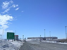
Photos • Location
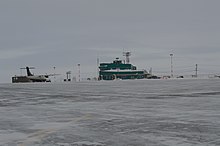
Ramp
The
DND Forward Operating Location hangars for
CF-18's in Rankin Inlet


Rankin Inlet Airport | |||||||||||
|---|---|---|---|---|---|---|---|---|---|---|---|
 | |||||||||||
| Summary | |||||||||||
| Airport type | Public | ||||||||||
| Operator | Government of Nunavut | ||||||||||
| Location | Rankin Inlet, Nunavut | ||||||||||
| Time zone | CST ( UTC−06:00) | ||||||||||
| • Summer ( DST) | CDT ( UTC−05:00) | ||||||||||
| Elevation AMSL | 106 ft / 32 m | ||||||||||
| Coordinates | 62°48′38″N 092°06′53″W / 62.81056°N 92.11472°W | ||||||||||
| Map | |||||||||||
 CYRT Location in Nunavut  CYRT CYRT (Canada) | |||||||||||
| Runways | |||||||||||
| |||||||||||
| Statistics (2010) | |||||||||||
| |||||||||||
.jpg)
Rankin Inlet Airport ( IATA: YRT, ICAO: CYRT) is located at Rankin Inlet, Nunavut, Canada, and is operated by the government of Nunavut.
In December 2005 the Government of Nunavut announced that they would spend $3 million to improve the Instrument Landing System and expand the apron. [4]
Canadian NORAD Region Forward Operating Location Rankin Inlet is located on the southwest side of the runway and shares the use of the runway when operations necessitate.
Airlines and destinations
_Rankin.jpg)
| Airlines | Destinations |
|---|---|
| Calm Air | Arviat, Baker Lake, Chesterfield Inlet, Coral Harbour, Naujaat, Whale Cove, Winnipeg [5] |
| Canadian North | Iqaluit, Ottawa, Yellowknife [6] |
| Nolinor Aviation | Charter: Meadowbank, [7] Montreal–Mirabel, Val d'Or |
References
- ^ Canada Flight Supplement. Effective 0901 Z 16 July 2020 to 0901Z 10 September 2020.
- ^ Synoptic/Metstat Station Information
- ^ Total aircraft movements by class of operation — NAV CANADA flight service stations
- ^ Nunatsiaq News Archived 2006-11-21 at the Wayback Machine
- ^ Calm Air schedule Archived 2011-09-30 at the Wayback Machine
- ^ Full network schedule
- ^ "Nunavut joint-venture airline signs 10-year deal with Agnico Eagle". Nunatsiaq News. 2017-11-14.
External links
Wikimedia Commons has media related to
Rankin Inlet Airport.
- Past three hours METARs, SPECI and current TAFs for Rankin Inlet Airport from Nav Canada as available.
| By name | |
|---|---|
| By location indicator | |
| By province/territory | |
| By area | |
| National Airports System | |
| Related | |
|
| This article about an airport in Nunavut is a stub. You can help Wikipedia by expanding it. |