Photos • Location
Putneyville, Pennsylvania | |
|---|---|
Unincorporated community | |
| Coordinates: 40°56′48″N 79°19′03″W / 40.94667°N 79.31750°W | |
| Country | United States |
| State | Pennsylvania |
| County | Armstrong |
| Township | Mahoning |
| Elevation | 984 ft (300 m) |
| Time zone | UTC-5 ( Eastern (EST)) |
| • Summer ( DST) | UTC-4 (EDT) |
| GNIS feature ID | 1184507 [1] |
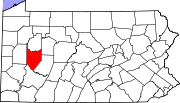
Putneyville is an unincorporated community in Mahoning Township, Armstrong County, Pennsylvania, United States. [1] [2] [3] [4]
History
A post office called Putneyville was established in 1844 and remained in operation until 1970. [5]
References
- ^ a b "Putneyville". Geographic Names Information System. United States Geological Survey, United States Department of the Interior.
- ^ "Armstrong County List of Names" (PDF). co.armstrong.pa.us. Armstrong County, Pennsylvania.
- ^ "KlTTANNING AND RURAL VALLEY QUADRANGLES, PENNSYLYANIA" (PDF). pubs.usgs.gov. United States Geological Survey.
- ^ "Armstrong County, TIP Projects, 2019 & Beyond" (PDF). penndot.gov. Pennsylvania Department of Transportation.
- ^ "Post Offices". Jim Forte Postal History. Retrieved November 6, 2018.

