New Princeton, Oregon | |
|---|---|
 New Princeton Post Office | |
 New Princeton  New Princeton | |
| Coordinates: 43°16′59″N 118°34′58″W / 43.28306°N 118.58278°W | |
| Country | United States |
| State | Oregon |
| County | Harney |
| Elevation | 4,111 ft (1,253 m) |
| Time zone | UTC-8 ( PST) |
| • Summer ( DST) | UTC-7 ( PDT) |
| ZIP code | 97721 |
| Area code(s) | 458 and 541 |
| Coordinates and elevation from United States Geological Survey [1] | |
New Princeton is an unincorporated community [1] in Harney County, in the U.S. state of Oregon. It is along Oregon Route 78 between Burns and Burns Junction [2] at an elevation of 4,111 feet (1,253 m) above sea level. [1] The South Fork Malheur River begins near Round Mountain, southeast of New Princeton. [3]
The Princeton rural post office was established in 1910 or about 1912, depending on the source consulted. When an upgrade of Route 78 bypassed the original community, it was re-located to New Princeton. [4]
According to the Köppen Climate Classification system, New Princeton has a semi-arid climate, abbreviated "BSk" on climate maps. [5]
New Princeton is in Harney County School District 4 (Crane School, grades K-8) and Harney County Union High School District 1J ( Crane Union High School). [6]
- ^ a b c "New Princeton". Geographic Names Information System. United States Geological Survey, United States Department of the Interior. November 28, 1980. Retrieved November 2, 2010.
- ^ Oregon Atlas and Gazetteer (Map) (1991 ed.). DeLorme Mapping. § 78. ISBN 0-89933-235-8.
- ^ "United States Topographic Map". United States Geological Survey. Retrieved January 1, 2016 – via Acme Mapper.
- ^ McArthur, Lewis A.; McArthur, Lewis L. (2003) [1928]. Oregon Geographic Names (7th ed.). Portland, Oregon: Oregon Historical Society Press. p. 785. ISBN 978-0875952772.
- ^ Climate Summary for New Princeton, Oregon
- ^ "2020 CENSUS - SCHOOL DISTRICT REFERENCE MAP: Harney County, OR" (PDF). U.S. Census Bureau. p. 1(PDF p. 2/3). Retrieved March 11, 2024. (at 78 @ Narrows Princeton Road) - Text list
- McArthur, Lewis A., and McArthur, Lewis L. (2003) [1928]. Oregon Geographic Names, 7th ed. Portland: Oregon Historical Society Press. ISBN 0-87595-277-1.
Municipalities and communities of
Harney County, Oregon, United States | ||
|---|---|---|
| Cities | 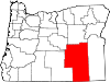 | |
| CDP | ||
|
Other communities | ||
| Indian reservation | ||
| Ghost towns | ||
| Desert | ||
|
| This Harney County, Oregon state location article is a stub. You can help Wikipedia by expanding it. |