Photos • Location

| Princess Louisa Marine Provincial Park | |
|---|---|
IUCN category II (
national park) | |
  | |
| Location | British Columbia, Canada |
| Nearest city | Powell River |
| Coordinates | 50°12′35″N 123°46′36″W / 50.20972°N 123.77667°W |
| Area | 9.64 km2 (3.72 sq mi) |
| Established | June 24, 1965 |
| Governing body | BC Parks |
| Website |
bcparks |
Princess Louisa Marine Provincial Park is a provincial park in British Columbia, Canada surrounding Princess Louisa Inlet. [1] [2] [3]
Gallery
-
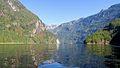 A view of Princess Louisa Inlet
 -
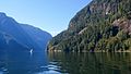
 Another inlet view
 -
 A boat travelling in calm waters
 -
 Boats docked at the park
 -
 A waterfall next to the coast


See also
References
External links
-
 Media related to
Princess Louisa Marine Provincial Park at Wikimedia Commons
Media related to
Princess Louisa Marine Provincial Park at Wikimedia Commons
50°12′20″N 123°46′13″W / 50.2056°N 123.7703°W
|
| This British Columbia protected areas related article is a stub. You can help Wikipedia by expanding it. |