Photos • Location


Pelkha | |
|---|---|
Village | |
| Coordinates: 29°52′N 77°29′E / 29.867°N 77.483°E | |
| Country | |
| State | Uttar Pradesh |
| District | Shamli |
| Government | |
| • Body | Gram panchayat |
| Languages | |
| • Official | Hindi |
| Time zone | UTC+5:30 ( IST) |
| ISO 3166 code | UP-IN |
| Coastline | 0 kilometres (0 mi) |
Pelkha is a village that lies 10 km north-west of Shamli in the district of Shamli in the state of Uttar Pradesh, India.
Gallery
-
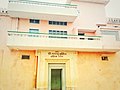 Kallu Mukhiya Dahiya Bhawan engraved on white marble at entrance. An old gate leading to the Haveli of Chaudhary Kallu Singh in Pelkha
 -
 Chaudhary Kallu Singh Haveli in Pelkha
 -
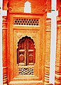 Intricate work at the Pelkha Haveli
 -
 Distant view of Haveli


External links
Wikimedia Commons has media related to
Pelkha.