Photos • Location
From Wikipedia, the free encyclopedia
(Redirected from
Parklands, Cape Town)
Suburb of Cape Town, in Western Cape, South Africa
Place in Western Cape, South Africa
Parklands | |
|---|---|
 | |
| Coordinates: 33°48′52″S 18°30′09″E / 33.81444°S 18.50250°E / -33.81444; 18.50250 | |
| Country | South Africa |
| Province | Western Cape |
| Municipality | City of Cape Town |
| Main Place | Blouberg |
| Government | |
| • Councillor | Meisie Sarah Makuwa (Ward 104) (
ANC) Jonathan Mills (DA) (Ward 107) |
| Area | |
| • Total | 2.47 km2 (0.95 sq mi) |
| Population (2011)
[1] | |
| • Total | 14,476 |
| • Density | 5,900/km2 (15,000/sq mi) |
| Racial makeup (2011) | |
| • Black African | 30.7% |
| • Coloured | 10.4% |
| • Indian/ Asian | 3.1% |
| • White | 54.2% |
| • Other | 1.6% |
| First languages (2011) | |
| • English | 56.7% |
| • Afrikaans | 16.3% |
| • Xhosa | 9.8% |
| • Zulu | 1.8% |
| • Other | 15.3% |
| Time zone | UTC+2 ( SAST) |
| Postal code (street) | 7441 |
| PO box | 2121 |
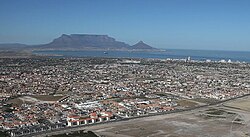
Parklands is a suburb of Cape Town, South Africa. It is located within the greater Blouberg area, bordered by Tableview, Cape Town and is part of the Western Seaboard residential district.
Parklands is one of the fastest-growing residential developments in the Western Cape. It is characterised by lower-density suburban areas and higher-density apartment block areas; the latter are largely inhabited by African diaspora residents. [2] [3]
References
- ^ a b c d "Sub Place Parklands". Census 2011.
- ^ "Wazimap visualisation of census data Ward 107". Wazimap.co.za.
- ^ "Wazimap visualisation of Ward 113 demographics". wazimap.co.za.
| International | |
|---|---|
| National | |
Retrieved from "
https://en.wikipedia.org/?title=Parklands,_Western_Cape&oldid=1228329843"

